
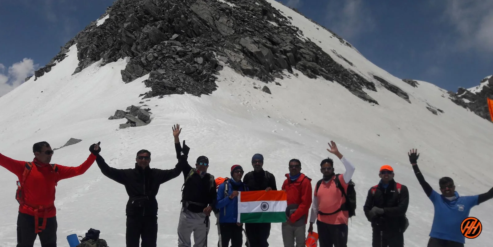


This expedition covers some very remote and famous areas which are popular amongst the trekkers. First is from where the River Ganga originates Gomukh, explore the green landscapes of Tapovan with streams around and the remote area Vasuki Tal.
Extraordinary Panorama views in Kalindi Pass Trek
To successfully complete the Kalindi Khal Pass trek, past experience of high altitude trekking and proper application of knowledge and skills should be known by the trekker. The risks are uncounted and you have to conquer the challenges, it is only possible when you come fully prepared.
Mana is the endpoint of this expedition and the last village of India. This place holds adventure and thrill, if you know proper skills and application then nothing can be better than conquering the challenges thrown in front and experiencing the adventure in Indian Himalayas.
Explore the Himalayas Beauty of this Remote Region Kalindi Pass
Kalindi pass trek in May to June ?
Kalindi pass Trek Month in May and june gives a slightly different experience to Trekkers because in May you start getting snow Gaumukh or Nandanvan Camps
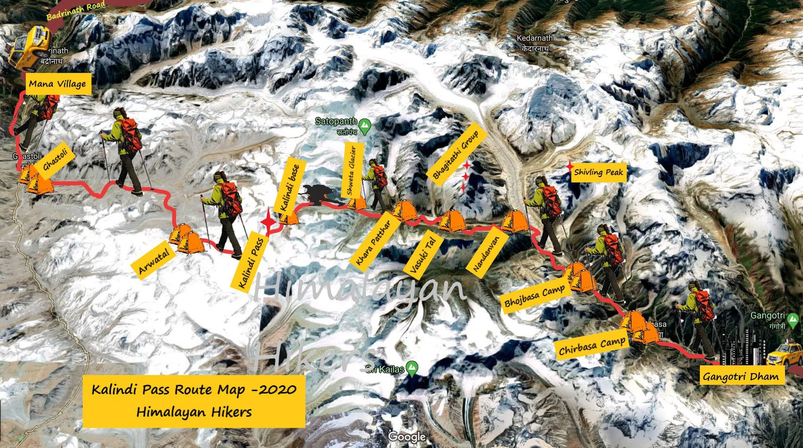
The Kalindi khal trek starts from Gangotri in Uttarakhand which comes in Gangotri National Park Range and end of trek Badarinath near mana village
In May and June, you get a combination of both greenery and snow, which makes the trek very spectacular. The weather in May and June is quite good and trek friendly, which makes trekking a lot of fun.
During the day the temperature of Kalindi pass trek is around ( 3°C to 8 °C and during the night the temperature comes down to -5 °C to -10 °C which is not easy trek
Views and treks in Kalindi pass trek provide a lot of peace to the mind during the day, while you wake up from one wake to another, Kalindi pass trek can always be one of the most close treks in your heart.
You will never consider yourself boring in Kalindi pass Trek, this trek can give you nothing but joy, You will get to see the Garhwal culture in this trek which will always keep you connected towards the mountain. Himalayas
Kalindi pass trek in September or October
Kalindi Pass Trek is a difficult trek, it should never be taken as a joke and never put yourself in trouble, In the month of September or October this trek is very great snow becomes very solid after Shweta Glacier it is easy to walk on top of snow, at this time there is a lot of rock and mud and walk in base snow
But the beauty of the trek will not be lacking, the trek and nature adorn themselves with time and in different colors. Month of September and October are very good days to trek, at this time total greenery and at the end of October sometimes you can get to see live snow fall.
During the day the temperature of Kalindi pass trek is around Day time 5°C to 12 °C and during the night the temperature comes down to -05 °C to – 08 °C which is very confirmable,
At this time the weather here will be very good for you , At this time it is even safe to trek here and there is no rain.
Why you should choose us Kalindi pass trek?
We’re here to give you the greatest experience possible through the eyes of highly skilled and qualified specialists who have a passion for adventure sports. We are community members attempting to promote our favorite adventure sports while also supporting local businesses. We, at Himalayan hikers, dedicate ourselves to providing you with an unforgettable experience.
Himalayan Hikers always make the trek from Trekkers memorable, I insist that you do not face any problem in any trek and you can always have a pleasant experience. Himalayan hikers 30 years old safest trekking team in Uttarakhand Himalaya.
Kalindi pass trek safe for Beginners ?
Kalindi pass trek is Difficult trek , this trek comes in a moderate to Difficult level, I myself have done this trek sometimes with me, people who are trekking for the first time, we have done the entire trek, they used to need help somewhere, which we and our team used to help.
Kalindi pass is a uphill trek but if your fitness is good and you have it in your mind that I want to trek then you can do it absolutely. Where help is needed, our guides will support you, you just have to be strong and capable of the trek. One thing is that all you can do is to have courage and I myself am passionate.
Note :–Kalindi pass trek should be done by those people who have experience of high altitude trek and are physically and mentally fit otherwise, this trek may be difficult for you. Before leaving, take care of experienced people, don’t make your life difficult.
- Level: – Difficult trek
- During the trek, proper conditioning & training of body is required.
- Also, need of proper gear & clothing for sub-zero temperature.
- Furthermore, shoes are the single most important equipment.
- High Altitude requires proper acclimatization.
- Beautiful landscapes so carry good photo gear & Extra battery backup.
- In addition, the backpack should not exceed 15 kg.
- Alcohol and smoking is not allowed in during the Expedition.
- need to proper knowledge of High altitude treks
Basic Information
| Category | Details |
|---|---|
| Best Season | Summer and Autumn |
| Best Month | After 2nd week of May, June, September, and October |
| Nearest Rail Head | Dehradun |
| Nearest Airport | Jolly Grant Airport (28 km from Dehradun) |
| Food | 5 Meals a day while on trek |
Kalindi pass Complete Guide
Our mission has always been to ensure that no trekker steps into the Himalayas without the right perspective. A trek is not just a checklist of summits; it is a serious commitment to the outdoors. Having the right information is what separates a reckless climb from a soulful journey.
This section serves as your definitive manual for the Kalindi pass. We have distilled years of mountain experience and real-time feedback into this guide to give you a clear, honest picture of the trail.
We provide this depth of information because we want you to be more than just a visitor—we want you to be a prepared, responsible trekker who respects the mountains as much as we do.
Day 1: Dehradun to Gangotri
Distance:258 km (Drive)
Duration:10–11 Hours
Altitude:3,415 meters (11,204 ft)
Highlight:A scenic drive along the Bhagirathi River, passing through Uttarkashi and Harshil.
Day 2: Rest & Acclimatization at Gangotri
Altitude:3,415 meters (11,204 ft)
Activity:Short hike to Pandu Gufa or Surya Kund. This day is crucial for your body to adjust to the thinning air before heading higher.
Day 3: Gangotri to Bhojbasa via Chirbasa
Distance:14 km (Trek)
Duration:7–8 Hours
Altitude:3,775 meters (12,385 ft)
Highlight:Trekking through the Gangotri National Park with the first clear views of the Bhagirathi peaks.
Day 4: Bhojbasa to Nandanvan via Gaumukh
Distance:8 km (Trek)
Duration:5–6 Hours
Altitude:4,340 meters (14,238 ft)
Highlight:Witnessing the snout of the Gangotri Glacier (Gaumukh) and a steep climb to the beautiful meadow of Nandanvan at the base of Bhagirathi peaks.
Day 5: Nandanvan to Vasuki Tal
Distance:6 km (Trek)
Duration:4–5 Hours
Altitude:4,880 meters (16,010 ft)
Highlight:Walking along the Chaturangi Glacier to reach the crystal-clear high-altitude Vasuki Tal lake.
Day 6: Acclimatization Day at Vasuki Tal
Altitude:4,880 meters (16,010 ft)
Activity:Rest and light exploration. This helps prepare for the high-altitude crossings ahead.
Day 7: Vasuki Tal to Khara Patthar
Distance:6 km (Trek)
Duration:4–5 Hours
Altitude:5,480 meters (17,979 ft)
Highlight:A steady ascent over moraine and glacial debris.
Day 8: Khara Patthar to Shweta Glacier
Distance:5 km (Trek)
Duration:4–5 Hours
Altitude:5,500 meters (18,044 ft)
Highlight:Walking on the "White Glacier," surrounded by massive peaks like Shivling and Satopanth.
Day 9: Shweta Glacier to Kalindi Base Camp
Distance:4 km (Trek)
Duration:4–5 Hours
Altitude:5,600 meters (18,372 ft)
Highlight:Reaching the final camp before the big pass. The terrain is entirely snow and ice.
Day 10: Acclimatization/Buffer Day
Altitude:5,600 meters (18,372 ft)
Note:Used for resting or as a backup in case of bad weather.
Day 11: Kalindi Base to Kalindi Pass – Descent to Arwatal
Distance:12 km (Trek)
Duration:10–12 Hours
Altitude:Pass: 5,950 meters (19,520 ft) | Arwatal: 3,980 meters (13,057 ft)
Highlight:The most challenging day. A steep climb to the pass followed by a long, knee-taxing descent to Arwatal.
Day 12: Arwatal to Ghastoli
Distance:8 km (Trek)
Duration:5–6 Hours
Altitude:3,796 meters (12,454 ft)
Highlight:Trekking through the Arwa Valley, following the river downstream.
Day 13: Ghastoli to Mana – Drive to Badrinath
Distance:9 km (Trek) + 3 km (Drive)
Duration:5–6 Hours
Altitude:3,100 meters (10,170 ft)
Highlight:Reaching the last village of India (Mana) and visiting the holy Badrinath Temple.
Day 14: Badrinath to Dehradun
Distance:320 km (Drive)
Duration:10–12 Hours
Highlight:A long drive back through the "Panch Prayag" (five confluences) to reach Dehradun by evening.
Day 1
Day 2
Day 3
Day 4
Day 5
Day 6
Day 7
Day 8
Day 9
Day 10
Day 11
Day 12
Day 13
Day 14
Day 1: Dehradun to Gangotri (The Journey to the Holy Source)
Total distance:258 km (Drive)
Duration:10–11 Hours
Altitude:3,415 meters (11,204 ft)
Terrain:Winding mountain roads, changing from lush sub-tropical forests to rugged alpine gorges.
Detailed Experience:Your journey begins early in the morning from Dehradun. As you drive past Mussoorie, the air turns crisp. The route snakes alongside the majestic Bhagirathi River, offering dramatic views of deep gorges. You will pass through Uttarkashi, a bustling pilgrim town, and Harshil, a picturesque valley famous for its apple orchards and wooden houses. The drive ends at Gangotri, one of the four sacred shrines of the Char Dham.
Pro-Tip:Keep motion sickness medication handy, as the mountain roads feature continuous hairpin bends.
Day 2: Rest & Acclimatization at Gangotri
Altitude:3,415 meters (11,204 ft)
Activity:Short acclimatization hike (3–4 km) to Pandu Gufa or Surya Kund.
Why it Matters:You have climbed significantly from Dehradun (640m) to over 3,400m in a single day. This day is absolutely non-negotiable for your body to adjust to the lower oxygen levels.
Detailed Experience:Spend your morning exploring the holy Gangotri Temple and witnessing the powerful waters of Surya Kund. In the afternoon, take a slow, rhythmic hike to Pandu Gufa (a historic cave where the Pandavas are believed to have meditated). This light physical exertion forces your lungs to adapt without exhausting your muscles. Hydrate aggressively throughout the day.
Day 3: Gangotri to Bhojbasa via Chirbasa
Total distance:14 km (Trek)
Duration:7–8 Hours
Altitude:3,775 meters (12,385 ft)
Terrain:Well-defined trail within the Gangotri National Park, gradual incline, sandy stretches, and rocky boulder zones.
Detailed Experience:After completing the forest department permissions, you enter the pristine Gangotri National Park. The trail climbs gradually through dense forests of pine and cedar before opening up to the birch (Bhojpatra) forests. Midway through, you will cross Chirbasa (the abode of pine trees), where you get your first breathtaking, clear views of the Bhagirathi I, II, and III peaks. The final stretch to Bhojbasa runs parallel to the roaring river, ending at a wide, desolate riverbed campsite.
Day 4: Bhojbasa to Nandanvan via Gaumukh (The Glacier Crossing)
Total distance:8 km (Trek)
Duration:5–6 Hours
Altitude:4,340 meters (14,238 ft)
Terrain:Moraine, loose scree, hard ice, and a steep vertical climb up a mountain wall.
Detailed Experience:Today the real adventure begins. You trek 4 km to Gaumukh, the massive, towering snout of the Gangotri Glacier and the geographical source of the River Ganges. Witnessing blocks of ice crash into the muddy waters is humbling. From Gaumukh, you step onto the actual glacier. The path is a maze of terminal moraine, crevasses, and shifting boulders. After navigating the glacier, you face a grueling, near-vertical climb on loose scree to reach Nandanvan, a vast, flat, emerald-green meadow.
Highlight:Nandanvan offers unparalleled, close-up views of the legendary Mount Shivling, Meru, and Kedar Dome.
Day 5: Nandanvan to Vasuki Tal (Walking with the Giants)
Total distance:6 km (Trek)
Duration:4–5 Hours
Altitude:4,880 meters (16,010 ft)
Terrain:Narrow ridges, lateral moraine, and slippery glacial debris along the Chaturangi Glacier.
Detailed Experience:You walk along the edge of the Chaturangi (Four-colored) Glacier, named after its striking streaks of red, yellow, grey, and black rocks. The trail is highly dynamic due to constant landslides and shifting moraine. You will have to negotiate narrow ridges with steep drops. The tough walk is richly rewarded when you arrive at Vasuki Tal, a pristine, crystal-clear, high-altitude lake. The reflection of the massive Mount Satopanth in the still water is a sight you will never forget.
Day 6: Acclimatization Day at Vasuki Tal
Altitude:4,880 meters (16,010 ft)
Activity:Rest, gear checks, and a brief climb to a nearby ridge (approx. 5,000m).
Why it Matters:You are now hovering around the 5,000-meter mark. The air is thin, and the temperature drops rapidly after sunset.
Detailed Experience:Use this day to rest your legs, dry out your gear, and practice using your technical equipment (crampons, ice axes, harness). A short, slow climb to a nearby ridge in the afternoon will help your body prepare for the punishing altitudes of the coming days. Sleep early and drink plenty of warm fluids.
Day 7: Vasuki Tal to Khara Patthar
Total distance:6 km (Trek)
Duration:4–5 Hours
Altitude:5,480 meters (17,979 ft)
Terrain:Extremely steep, boulder-strewn terrain with no visible trail.
Detailed Experience:The trek enters a wildly remote zone. Leaving the lake behind, you start a steep and demanding ascent over massive rocks and loose stones. The name Khara Patthar translates to "Standing Stone," perfectly describing the rugged, jagged nature of this campsite. Every step requires concentration as the rocks can be unstable. You will camp in a harsh, cold, completely rocky landscape surrounded by imposing walls of black rock and white ice.
Day 8: Khara Patthar to Shweta Glacier (Entering the White Desert)
Total distance:5 km (Trek)
Duration:4–5 Hours
Altitude:5,500 meters (18,044 ft)
Terrain:Crevassed ice fields, hard snow, and glacial moraine.
Detailed Experience:Today you step onto the spectacular Shweta Glacier (literally meaning the White Glacier). Unlike the debris-covered Gangotri glacier, large parts of this glacier are pure, blinding white snow and ice. You will need to wear sunglasses to prevent snow blindness. The trek is short in distance but physically exhausting due to the extreme altitude. You are camping directly on the glacier tonight; the sub-zero temperatures will require premium winter layers.
Day 9: Shweta Glacier to Kalindi Base Camp
Total distance:4 km (Trek)
Duration:4–5 Hours
Altitude:5,600 meters (18,372 ft)
Terrain:Pure snow fields, steep snowy slopes, and potentially hidden crevasses.
Detailed Experience:A short but intense pull through a landscape that feels like Antarctica. You will be roped up for safety as you navigate the snowfields leading to the Kalindi Base Camp. You are now surrounded by an amphitheater of towering giants: Avalon, Chandra Parvat, and the formidable Kalindi peak itself. The campsite is set up entirely on snow.
Preparation:The guides will brief you on the exact plan for the pass crossing tonight, as the push begins in the dead of the night.
Day 10: Acclimatization / Buffer Day
Altitude:5,600 meters (18,372 ft)
Note:This day is strictly reserved as a contingency plan. High-altitude passes like Kalindi Khal are notorious for sudden, violent blizzards and heavy whiteouts. If the weather is clear, your team might choose to skip this rest day and cross immediately, saving the buffer day for later. If held back, it is used to rest and conserve energy.
Day 11: Kalindi Base to Kalindi Pass – Descent to Arwatal (The Grand Finale)
Total distance:12 km (Trek)
Duration:10–12 Hours
Altitude:Pass: 5,950 meters (19,520 ft) | Arwatal: 3,980 meters (13,057 ft)
Terrain:Very steep snow walls, bergschrunds/crevasses, followed by a punishing, slippery, rock-and-ice descent.
Detailed Experience:Your alarm rings at 1:00 AM. Under a blanket of billions of stars, roped up and wearing headlamps, you begin the arduous climb to the top of the pass. The final incline to the Kalindi Khal Pass (5,950m) is a near-vertical wall of snow. Reaching the summit just as the sun rises is a spiritual experience—you are standing higher than almost any other trekking pass in the world. After celebrating at the pass, the toughest part begins: a steep, technically challenging, and knee-jarring descent down the other side into the Badrinath Valley. You drop nearly 2,000 meters in altitude to reach the safety of the Arwatal campsite next to a glacial lake.
Day 12: Arwatal to Ghastoli (The Return to Civilization)
Total distance:8 km (Trek)
Duration:5–6 Hours
Altitude:3,796 meters (12,454 ft)
Terrain:Rock-strewn trails, wide river valleys, and river crossings.
Detailed Experience:With the extreme altitudes behind you, your body will instantly feel the relief of richer oxygen. You will trek along the beautiful, desolate Arwa Valley, following the Arwa River downstream. The valley gradually widens, revealing vast plains. You will cross a few freezing streams before reaching Ghastoli, an open meadow that also serves as an important Indian Army/ITBP (Indo-Tibetan Border Police) post.
Day 13: Ghastoli to Mana – Drive to Badrinath (The Concluding Pilgrimage)
Total distance:9 km (Trek) + 3 km (Drive)
Duration:5–6 Hours
Altitude:3,100 meters (10,170 ft)
Terrain:Well-laid stone trails, gravel paths, and a paved motorable road.
Detailed Experience:Your final day of trekking is a pleasant walk down towards Mana Village, officially recognized as the "Last Village of India" before the Tibetan border. Here, you will see iconic cultural sites like Vyas Gufa and the natural rock bridge Bheema Pul. From Mana, a short 3 km vehicle drive brings you to the holy town of Badrinath. Check into a hotel, enjoy a long-awaited hot shower, and visit the vibrant Badrinath Temple in the evening to offer thanks for a safe trek.
Day 14: Badrinath to Dehradun
Total distance:320 km (Drive)
Duration:10–12 Hours
Detailed Experience:A long but incredibly scenic drive back to Dehradun. You will drive along the Alaknanda River, passing through the famous Panch Prayag—the five holy river confluences: Vishnuprayag, Nandaprayag, Karnaprayag, Rudraprayag, and Devprayag (where the Alaknanda meets the Bhagirathi to officially become the Ganga). You will reach Dehradun by late evening, marking the end of an epic expedition.
Kalindi pass trek is Difficult trek , this trek comes in a moderate to Difficult level, I myself have done this trek sometimes with me, people who are trekking for the first time, we have done the entire trek, they used to need help somewhere, which we and our team used to help.
Kalindi pass is a uphill trek but if your fitness is good and you have it in your mind that I want to trek then you can do it absolutely. Where help is needed, our guides will support you, you just have to be strong and capable of the trek. One thing is that all you can do is to have courage and I myself am passionate.
Note :–Kalindi pass trek should be done by those people who have experience of high altitude trek and are physically and mentally fit otherwise, this trek may be difficult for you. Before leaving, take care of experienced people, don’t make your life difficult.
Kalindi pass trek is a very beautiful and an uphill Difficult trek in the Uttarakhand Himalayas, The Kalindi pass Trek is great for those people who have a great passion for Expedition mountaineering or Difficult trek and consider it a special purpose in their life. Kalindi pass is such a trek where you get to see more than one Himalayan mountain range.
We are the local people in uttarakhand District of Uttarkashi who are doing Kalindi khal trek for years, we have every experience related to this trek.
The right time to do Kalindi pass trek is from May 3st week to the last of June and then from the last of August to the 2nd week of October. every year.
specially in the months of may, and June, snow is found in abundance here, which makes your trek very memorable and also a difficult after Gaumukh Glacier. So this trek should not be considered too easy
If you are traveling from Kolkata, Bengaluru, Chennai, Pune, Mumbai, or Gujarat any other city, so you will have to come to Delhi, you will get a train from Delhi for Dehradun comfortably.
How to Reach Dehradun
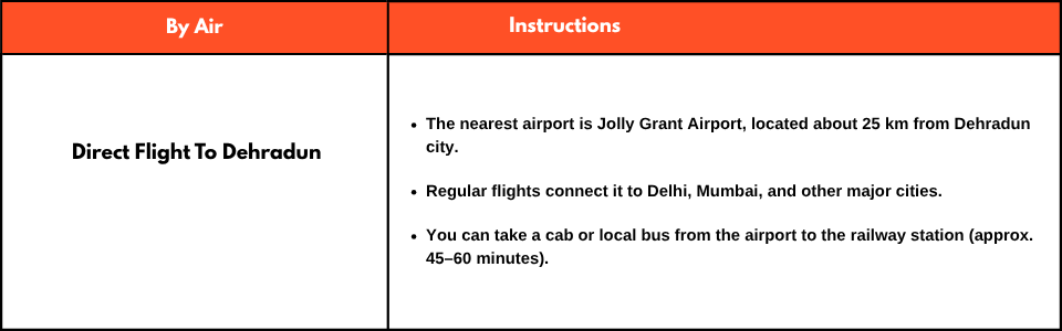
Whether you're coming from Delhi, Mumbai, or another city, here are your options to reach Dehradun:
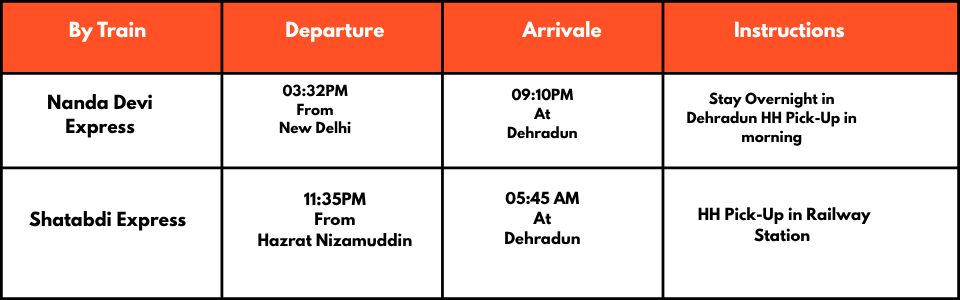
By Train
By Bus

Pro Tip:Buses are also available from cities like Haridwar, Moradabad, Rishikesh, and Chandigarh.
Mobile Connectivity and ATMs for Trek
ATM Availability
Before starting the journey to Kalindi Khal trek, make sure that you need payments, and then take out the cash on the way, Uttarkashi market is the last place where you can withdraw cash from ATM, (If you want to withdraw money then do it in Dehradun).
Mobile Network Connectivity
The phone does not work on this trek. Therefore, you should ensure that you do not have to make any important calls. So make sure you finish all your important work and calls before starting the trek. Last Gangotri base camp, your device will receive good networks
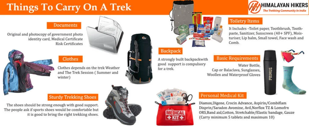
Necessary Items for trekkers
Mandatory Documents
Original and photocopy of government photo identity card- (Aadhar Card, Driving License, Voters ID, etc,)
Passport and Visa important to foreigners
Medical Certificate (First part should be filled by the Doctor and Second part by the Trekker)
Declaration Certificates
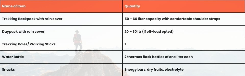
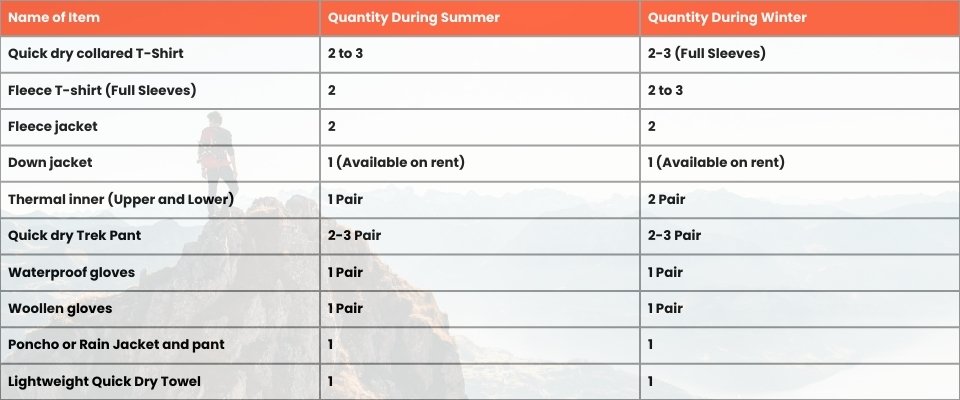
Note: – Many trekkers commit the same mistake of carrying unnecessary items on a trek which only makes the backpack heavy. It is important to know the right items to carry. It differs from season to season if you are trekking in summers then carry less layers of warm clothing and if you are trekking in winters carry enough layers to protect yourself against chilly cold.
Basic Trekking Gears
The Clothes You Should Bring On Satopanth Expedition
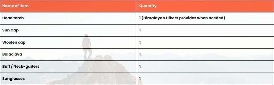
Head Gears
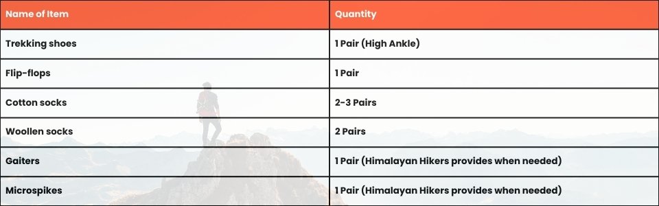
Foot Gears
Personal Care Essentials

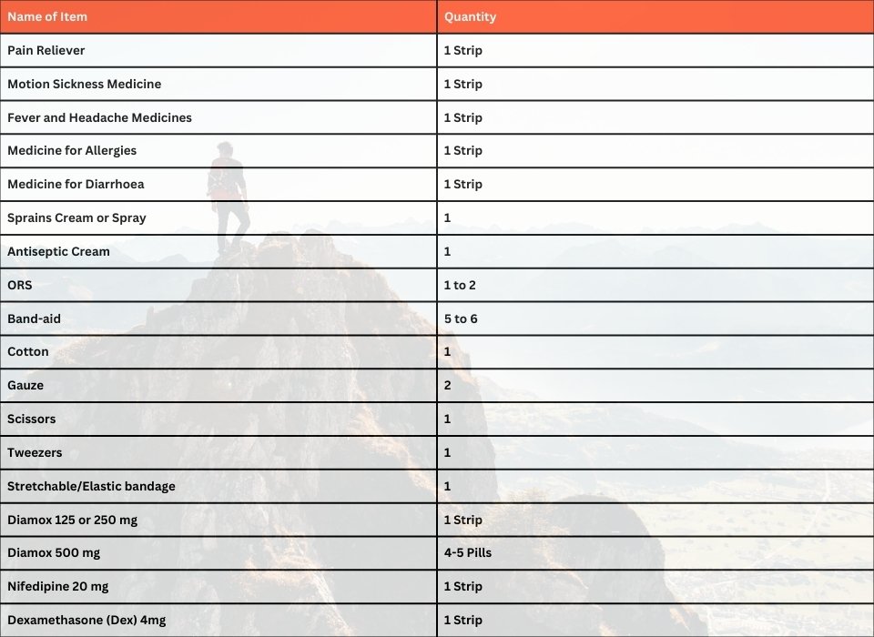
Carry a Personal Medical Kit
Are you Looking for Trekking Equipment on Rent?
If any trekker requires trekking equipment on rent, Himalayan Hikers offers the best-quality gear available for rental. Many individuals are in need of such equipment, and renting provides a cost-effective solution, allowing them to access high-quality gear at an affordable price without the need for a significant investment for short-term use.
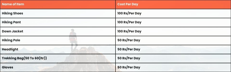
Trek Equipment You can book directly on first day at the Base Camp.
Note:-
Please take all medicines only when prescribed by the doctor. In case you face any problem during your trek,
discuss and take advice from the Professional guide.
The Trek is one of the most popular treks in Uttarakhand, Himachal,Kashmir,Laddakh,Sikkim,Nepal, requiring both physical preparation and mental readiness. Although it is categorized as a moderate trek, reaches an elevation of over 12,720 feet and traverses remote Himalayan terrain, which can be physically and mentally challenging. Here's how you can prepare yourself for a safe and successful accomplishment of the Trek:
Physical Fitness
Building a good fitness base is essential for every trekker. The Trek itinerary involves 5 to 6 hours of walking every day. Though the trails are well-marked, they are often bumpy and include steep uphill sections, which may affect your stamina. You can overcome your physical limitation with a 6-week training program that you can begin about 2 months before your Trek. Your 6-week fitness routine should include

Pro Tip: If you have time, you can skip the Sunday training and go for a long-distance walk or mini day-hike (7–10 km) with a loaded backpack to simulate real trekking conditions. A short 1-day hike around your city/town can help a lot.
Mental Preparation
Physical strength is only half the journey, the other half is mental resilience. The trail takes you through remote clearings, steep climbs, cold starry nights, and no mobile connectivity. Be prepared to:
(I) - Detach from the digital world.
(II) - Embrace basic mountain living (camping, toilet tents, limited electricity).
(III) - Push through moments of fatigue, weather discomfort, or altitude effects.
A positive mindset, patience, and the ability to adapt will carry you farther than muscle ever could.
Local expertise:
Himalayan Hikers is a local trekking company based in Uttarakhand, India. They have extensive knowledge and experience of the Trek, including the terrain, weather, and culture of the region. This can help ensure a safe and enjoyable trekking experience.
Experienced Guides:
The guides at Himalayan Hikers are experienced and certified. They have a good understanding of the Trek route and can provide valuable insights into the culture and traditions of the local communities.
Good reviews:
Himalayan Hikers has received positive reviews from previous clients who have completed the Trek. They are known for their professionalism, excellent service, and commitment to safety.
Sustainable tourism:
Himalayan Hikers is committed to promoting sustainable tourism practices on the Trek. They follow Leave No Trace principles, use eco-friendly trekking equipment, and support local communities by hiring local staff and using locally sourced food.
Customized itineraries:
Himalayan Hikers offers customized itineraries for the Trek to suit the needs and preferences of their clients. They can tailor the trekking experience to your fitness level, time constraints, and interests.
Affordable Prices:
Himalayan Hikers offers competitive prices for their Trek packages. They provide a range of packages that cater to different budgets and requirements.
Package Cost Includes
- Transport from Dehradun-to-Dehradun Tempo or Taxi Non /AC
- Forest Permit and entrance fee
- Accommodation in Gangotri Hotel Mandakini 2 nights
- Accommodation in Tents on twin share basis
- All meals: Breakfast, Lunch, Tea, Coffee, Snacks, Soup and Dinner
- Radio Walkie Talkie for Communication
- High quality 04 season Dome tents
- Sleeping bags -15 working
- Mattress
- Liner
- Toilet tent
- Dining Tent
- Camping stole
- Porters’ High-altitude workers
- Kitchen team
- Good Experience Trek Leader Guide and technical guide- Sherpa
- Medical Kit
- Oxygen Cylinders
- Gaiters, Crampons
- Rope, Seat harness, ice Axe, Polly, helmet, jumar, Desander more
Package Cost Excludes
- Personal Insurance mandatory for kalinda pass expedition permit
- Personal toiletry Items – Medical kit
- On the first day en route to base camp the breakfast and lunch are not included
- last day en route lunch and dinner are not included
Important Note
Please carry your own personal medication, trekking gear, and thermal layers. Ensure you have a valid travel insurance policy covering high-altitude trekking (above 5,000 m) as it is mandatory for the Kalindi Pass expedition.
No FAQs available for this trek.


.webp)


