


The allure of this trek stems from its diversity. You start in the refreshing shade of the oak forest; the only sounds are the melodies of birds and the rhythm of your footsteps. Gradually, the trees become less dense, the valley broadens, and the scenery transforms into an open high-altitude meadow that every Himalayan adventurer dreams about, whilst the majestic mountains stare right at you, such as Nanda Devi, Dronagiri, Chaukhamba, Trishul, and Nanda Ghunti.
Because Dyalishera remains an offbeat choice compared to Uttarakhand's more popular treks, you can enjoy long stretches of tranquility, room for contemplation, and a genuine sense of being far removed from everything. This is a true high-altitude adventure, where every viewpoint is hard-earned, which is exactly what makes the memories unforgettable. It caters to beginners who have achieved a decent level of fitness, experienced walkers seeking something new, photographers pursuing dramatic shots, and friends looking to spend a week enjoying laughter around a campsite.
Here are some of the highlights of the Dyalishera Bugyal Trek:
Panoramic Himalayan views: You get an unobstructed view of the most iconic Himalayan mountains such as Nanda Devi, Dronagiri, Chaukhamba, Trishul, etc.
Diverse scenery: Golden oak forests, quiet valleys, and lush alpine meadows all appear along the journey.
Offbeat and peaceful: A quieter alternative to Uttarakhand's more popular routes, you get more peace and the whole trail to yourself.
Just right in length: The trek takes about six days, long enough to feel like a real escape and short enough to fit into a busy schedule.
Suitable for first-timers: Perfect for first-timers with some fitness level and seasoned trekkers looking for something new.
Dyalishera Trek Complete Guide
Our mission has always been to ensure that no trekker steps into the Himalayas without the right perspective. A trek is not just a checklist of summits; it is a serious commitment to the outdoors. Having the right information is what separates a reckless climb from a soulful journey.
This section serves as your definitive manual for the Dyalishera Trek. We have distilled years of mountain experience and real-time feedback into this guide to give you a clear, honest picture of the trail.
We provide this depth of information because we want you to be more than just a visitor—we want you to be a prepared, responsible trekker who respects the mountains as much as we do.
Day 1: Drive from Dehradun via Rishikesh to Joshimath to Karchon(Base Camp)
Altitude: 6,561 ft | Drive Distance: 290 km | Drive Duration: 10 hours | Pick-up point for Himalayan Hikers trekkers: Prince Chowk, near Dehradun Railway Station.
Day 2: Trek from Karchon to Dhurkund Meadow
Altitude: 9,186 ft | Trek Distance: 7 km | Trek Duration: 6 hours | Trek Difficulty: Easy to Moderate | Overnight Stay: Dhurkund Campsite (Twin Sharing)
Day 3: Trek from Dhurkund Camp to Dyalishera Meadow
Altitude: 11,155 ft | Trek Distance: 7 km | Trek Duration: 6 hours | Trek Difficulty: Easy to Moderate | Overnight Stay: Dyalishera Campsite (Twin Sharing)
Day 4: Rest and exploration day at Dyalishera Meadow and surroundings
Altitude: 11,155 ft | Overnight Stay: Dyalishera Campsite (Twin Sharing)
Day 5: Trek from Dyalishera Meadow back to Karchon (Base camp)
Altitude: 6,561 ft | Trek Distance: 10 km | Trek Duration: 7 hours | Overnight Stay: Karchon
Day 6: Depart from Karchon to Joshimath to Dehradun via Rishikesh
Altitude Loss: 7,545 ft to 2,089 ft | Drive Distance: 290 km | Drive Duration: 9 to 10 hours | Drop-off point for Himalayan Hikers trekkers: Prince Chowk, near Dehradun Railway Station
Day 1
Day 2
Day 3
Day 4
Day 5
Day 6
Day 1: Drive from Dehradun via Rishikesh to Joshimath to Karchon Base Camp
Altitude: 6,516 ft | Drive Distance: 290 km | Drive Duration: 9 to 10 hours | Overnight Stay: Karchon Base Camp | Pick-up point for Himalayan Hikers trekkers: Prince Chowk, near Dehradun Railway Station
Route: Dehradun → Rishikesh → Devprayag → Srinagar (Garhwal) → Rudraprayag → Karnaprayag → Nandaprayag → Joshimath→Karchon
Himalayan Hikers organizes transport for trekkers from Dehradun or Rishikesh in the morning, which will leave for Karchon around 6:00 am to 7:00 am. The Drive from Dehradun Via Rishikesh to Karchon, which serves as the base camp for the Dyalishera Bugyal trek, offers several scenic viewpoints along the way.
Here are some notable viewpoints you can encounter during the journey:
Devprayag: Devprayag is the confluence of the Alaknanda and Bhagirathi rivers, where they merge to form the holy river Ganges. It is a significant pilgrimage site and offers a picturesque view of the river’s meeting point.
Rudraprayag: Rudraprayag is another confluence point on the route, where the Alaknanda and Mandakini rivers merge. The town is surrounded by the scenic beauty of the Himalayas and is considered sacred by Hindus.
Karnaprayag: Karnaprayag is yet another confluence point, where the Alaknanda River meets the Pindar River. It is located at the confluence of the Pindar and Alaknanda valleys, providing beautiful views of the rivers and surrounding mountains.
Nandaprayag: Nandaprayag is the confluence of the Alaknanda River and the Nandakini River. It holds religious significance and is one of the Panch Prayag (five sacred river confluences) in Uttarakhand. The town is named after King Nanda, who is believed to have performed a yajna (sacred ritual) here. It is a peaceful stopover on the route to Joshimath and the Himalayan trekking trails.
Day 2: Trek from Karchon to Dhurkund Meadow
Altitude Gain: 9,186 ft | Trek Distance: 7 km | Trek Duration: 6 hours | Trek Difficulty: Easy to Moderate | Overnight Stay: Dhurkund Campsite (Twin Sharing)
Travel from Joshimath to Karchon by taxi, which is a distance of approximately 15 kilometers. Once you reach Karchon, you can start your trek to the Gulling camp viewpoint on the same day.
Trek from Karchon to Dhurkund: Once you reach Karchon, you can begin your trek towards the Dhurkund camp viewpoint. The trail from Karchon to Dhurkund is approximately 7 km and can take around 6 hours, depending on your pace.
Enjoy the Viewpoint: As you trek from Tugasi to Gulling, you will be treated to beautiful views of the surrounding mountains, forests, and valleys. The Gulling camp viewpoint offers a panoramic vista of the Himalayan landscape.
Overnight Stay: After spending some time at the Dhurkund camp viewpoint and enjoying the scenery, you will camp overnight at Dhurkund.
Day 3: Trek from Dhurkund Camp to Dyalishera Meadow
Altitude: 11,014 ft | Trek Distance: 7km | Trek Duration: 6 hours | Trek Difficulty: Easy to Moderate | Overnight Stay: Dyalishera Campsite (Twin Sharing)
The trek begins with a steady ascent through a thick forest of oak and rhododendron (Buransh). If you are trekking in early spring, the trail is often carpeted with crimson Rhododendron flowers. In winter, this section stays snow-covered longer because the canopy blocks the sunlight.
First Glimpses of the Giants
As the treeline begins to thin, the "Big Guns" of the Garhwal Himalayas start peering over the ridges. You will get clear views of Dronagiri, Trishul, and Nanda Ghunti, etc.
Transition to the Alpine Meadows
About halfway through, you break out of the forest. The landscape changes instantly from dark greens to the golden-brown or lush green (depending on the season) of the Alpine Bugyals. This is where the air feels thinner, and the views become 360-degree panoramic.
Day 4: Rest and exploration day at Dyalishera Meadow and surroundings
Altitude: 6,561 ft | Overnight Stay: Dyalishera Campsite (Twin Sharing)
Explore the area around Dyalishera Meadow. Experience the highest and the truest form of Himalayan tranquility- just you and your thoughts. What better place to introspect than here?
Day 5: Trek from Dyalishera Meadow back to Karchon (Base camp)
Altitude: 11,014 ft to 8,530 ft to 7,545 ft | Trek Distance: 8.5 km | Trek Duration: 6 to 7 hours | Trek Distance: 10 km | Trek Duration: 7 hours | Overnight Stay: Karchon
Start early in the morning from the Dyalishera campsite.
Follow the trail downhill.
The trek from Dyalishera to Karchon Village is approximately 7 kilometers and can take around 6-7 hours, depending on your pace and the trail conditions.
Rest for the day at the base camp, as the next day will be the departure and the final day of the trek.
Day 6: Depart from Karchon to Joshimath to Dehradun via Rishikesh
Altitude Loss: 7,545 ft to 2,089 ft | Drive Distance: 290 km | Drive Duration: 9 to 10 hours | Drop-off point for Himalayan Hikers trekkers: Prince Chowk, near Dehradun Railway Station
Route: Karchon→Joshimath → Nandaprayag → Karnaprayag → Rudraprayag → Srinagar (Garhwal) → Devprayag → Rishikesh → Dehradun
After breakfast, we will leave early at 6 am, have lunch en route, and you can reach Dehradun in the evening between 6 and 7 pm.
The return journey from Joshimath to Rishikesh typically involves a scenic drive through the mountains, offering beautiful views of the valleys, rivers, and Himalayan landscapes. The distance from Joshimath to Rishikesh is approximately 280 kilometers, and the drive takes around 9 to 10 hours, depending on the road and traffic conditions.
During the drive, you may pass through picturesque towns and villages, such as Chamoli and Devprayag, where you can witness the confluence of rivers and visit temples or other attractions. The road winds through the mountains, offering glimpses of the stunning natural beauty of the region.
It’s always advisable to start early in the morning to allow ample time for the drive and to avoid traffic congestion. Along the way, you can take breaks at roadside dhabas.
The Dyalishera Bugyal trek is generally considered to be a moderate trek, suitable for beginners and experienced trekkers alike. It offers a beautiful and relatively accessible trail through the Garhwal Himalayas in Uttarakhand, India.
The trek usually takes around 6 days and 5 nights to complete, covering a distance of approximately 24 kilometers round trip. The trail involves moderate ascents and descents. However, compared to other high-altitude treks in the region, the Dyalishera Bugyal trek has a relatively gradual ascent, making it more manageable for beginners.
Altitude sickness is generally not a major concern on this trek unless you have a pre-existing condition or are particularly sensitive to altitude.
While physical fitness and stamina are important for any trek, including this one, it is advisable to prepare yourself with regular exercise and some pre-trek training to enhance your endurance and strength. It’s also recommended to acclimatize properly by taking rest days and staying hydrated during the trek.
Dyalishera Bugyal Trek: Safe or Best Treks For Beginners?
Yes, the Dyalishera trek is generally considered safe and suitable for beginners. While it is always important to be prepared and take necessary precautions when embarking on any trek, it offers a relatively moderate level of difficulty that can be managed by beginners who are physically fit and prepared.
Here are a few reasons why the Dyalishera Bugyal trek is often recommended for beginners:
Moderate Difficulty: The trek involves moderate ascents and descents, with gradual climbs and manageable terrain. While there are some steep sections and rocky paths, they can be tackled with proper care and trekking techniques.
Well-Defined Trail: The trail for Dyalishera is well-marked and well-defined, making navigation easier for beginners. This reduces the chances of getting lost or straying off the intended path.
Trekking Infrastructure: There is a decent infrastructure in place, including trekking guides, local support staff, and well-established campsites along the route. This provides a level of comfort and assistance for beginners who may not have extensive trekking experience.
Limited Altitude Concerns: While the trek reaches a maximum altitude of around 12,516 feet at the Dyalishera meadow, the gradual ascent and the overall altitude profile of the trek make it less prone to altitude sickness. However, it’s always important to be aware of the symptoms of altitude sickness and take necessary precautions.
Despite being considered safe for beginners, it’s still recommended to prepare adequately for the trek. This includes physical fitness training, carrying the necessary gear and supplies, and consulting with experienced trekkers or local guides for any specific advice or precautions related to the current conditions of the trek.
Remember to plan your trek well, be aware of your own limitations, and prioritize safety at all times.
Spring: March to May
Recommended for: First-time trekkers, photography lovers, comfortable weather.
What to expect:
Snow still on higher altitudes (till early April).
Rhododendron blooms and greenery in lower sections.
Gradual warming weather; pleasant days, cold nights.
Beautiful snow + greenery contrast.
Clear views of Himalayan peaks like Nanda Devi and Dronagiri. Ideal if you want a good mix of snow and comfort.
Autumn: September to November
Recommended for: Best Mountain views, stable weather, golden landscapes.
What to expect:
Clean, dry trails after monsoon.
Crisp, clear skies; panoramic views of the Himalayas.
Golden forests (especially oak and maple).
Best visibility for peaks.
Low rain risk and moderate cold. And arguably the best overall time to do the trek.
Crystal-Clear Mountain Views
Post-monsoon skies are clean and blue.
You'll get unobstructed views of snow-capped peaks like:
Nanda Devi, Dronagiri, Nanda Ghunti, Trishul, etc.
Very low chance of rain or snow.
No slippery or muddy trails (unlike in spring or monsoon).
Comfortable trekking conditions: warm sun during the day, chilly but manageable
nights. Forests in Autumn Colors
Oak, maple, and pine forests turn golden-orange.
Scenic campsites like Dhurkund look stunning in autumn light.
Comfortable Trekking Temperatures
Day: 10°C to 15°C
Night: 0°C to -5°C (cold but not freezing and Great for Beginners and photographers)
The trail is not too technical.
Excellent light conditions for photography, especially sunrise/sunset on the peaks.
1. Getting to Dehradun
Dehradun is the gateway for several popular treks in the Garhwal region of Uttarakhand, a Himalayan trekking base camp and starting point for treks in the Himalayas, including the Dyalishera Bugyal Trek. There are various ways to reach Dehradun, depending on your starting point:
By Air:
Nearest Airport: The Jolly Grant Airport (DEHRADUN) in Dehradun is the closest airport, around 25 km from the city center.
Flight Options:
Direct flights to Dehradun are available from major cities like Delhi, Mumbai, and Bangalore.
You can also fly to Delhi (Indira Gandhi International Airport) and take a flight or travel by road/train from there to Dehradun.
By Train:
Nearest Railway Station: Dehradun Railway Station.Train Services: Dehradun is well-connected to major cities like Delhi, Haridwar, and Lucknow. Some popular trains include:
Shatabdi Express from New Delhi to Dehradun (around 5-6 hours).
Nanda Devi Express from New Delhi to Dehradun (approximately 6-7 hours).
You can also check other overnight trains like Doon Express and Mussoorie Express for convenience.
By Bus:
Dehradun has a good bus network from cities like Delhi, Haridwar, Rishikesh, and other major destinations in Uttarakhand and North India.
From Delhi, Uttarakhand Transport Corporation (UTC) buses are frequent and take around 6-7 hours to reach Dehradun.
You can also opt for Volvo buses or private buses if you prefer comfort.
By Road:
If you are driving, Dehradun is well-connected by road.
From Delhi: Take NH44, which is approximately a 6-7 hour drive (approximately 270 km).
From Haridwar: Take NH58, which will take about 1-2 hours (55 km).
From Rishikesh: It’s about a 1-1.5 hour drive (35 km).
Himalayan Hikers has arranged transport for you from Dehradun Railway Station to Joshimath via Rishikesh at 6 AM. Here’s a detailed guide on what you can expect during this journey:
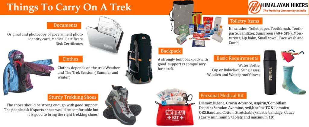
Necessary Items for trekkers
Mandatory Documents
Original and photocopy of government photo identity card- (Aadhar Card, Driving License, Voters ID, etc,)
Passport and Visa important to foreigners
Medical Certificate (First part should be filled by the Doctor and Second part by the Trekker)
Declaration Certificates
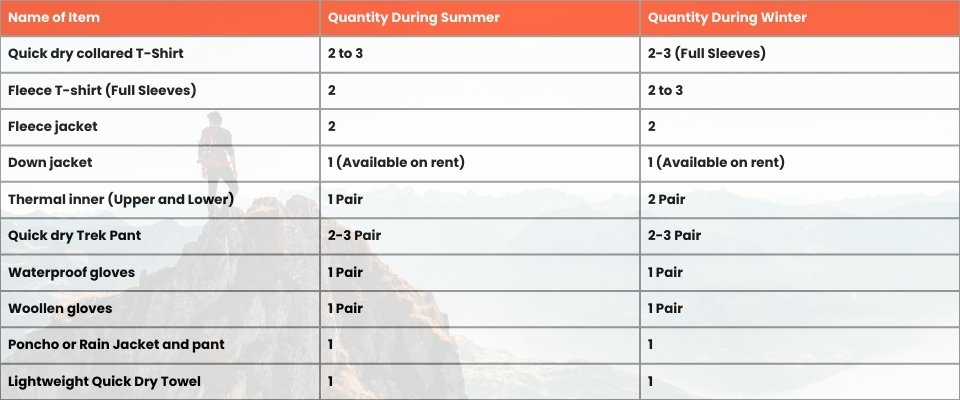
Note: – Many trekkers commit the same mistake of carrying unnecessary items on a trek which only makes the backpack heavy. It is important to know the right items to carry. It differs from season to season if you are trekking in summers then carry less layers of warm clothing and if you are trekking in winters carry enough layers to protect yourself against chilly cold.
Basic Trekking Gears
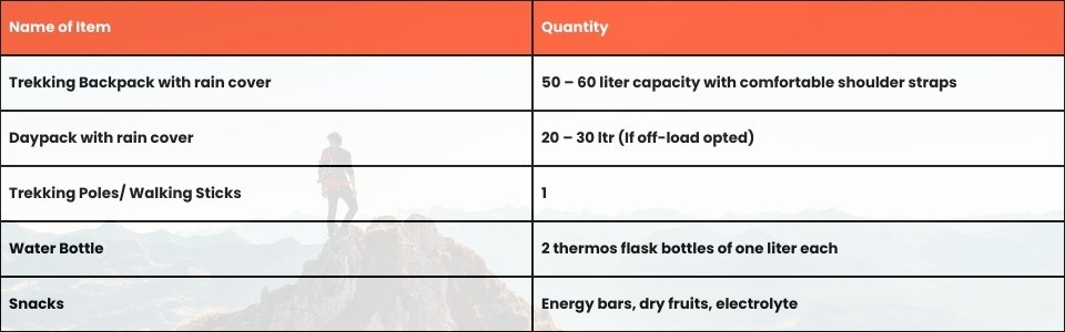
The Clothes You Should Bring On Satopanth Expedition
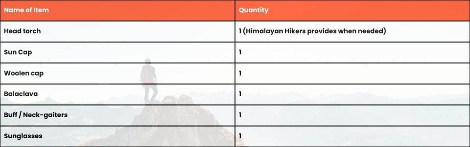
Head Gears
Foot Gears
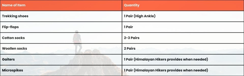
Personal Care Essentials

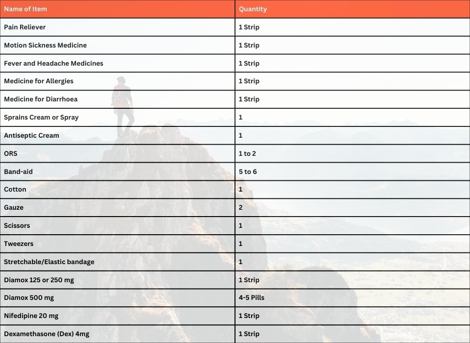
Carry a Personal Medical Kit
Are you Looking for Trekking Equipment on Rent?
If any trekker requires trekking equipment on rent, Himalayan Hikers offers the best-quality gear available for rental. Many individuals are in need of such equipment, and renting provides a cost-effective solution, allowing them to access high-quality gear at an affordable price without the need for a significant investment for short-term use.
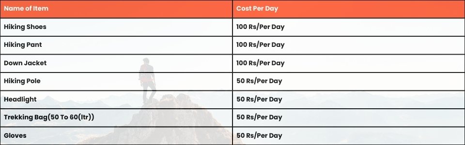
Trek Equipment You can book directly on first day at the Base Camp.
Note:-
Please take all medicines only when prescribed by the doctor. In case you face any problem during your trek,
discuss and take advice from the Professional guide.
The Trek is one of the most popular treks in Uttarakhand, Himachal,Kashmir,Laddakh,Sikkim,Nepal, requiring both physical preparation and mental readiness. Although it is categorized as a moderate trek, reaches an elevation of over 12,720 feet and traverses remote Himalayan terrain, which can be physically and mentally challenging. Here's how you can prepare yourself for a safe and successful accomplishment of the Trek:
Physical Fitness
Building a good fitness base is essential for every trekker. The Trek itinerary involves 5 to 6 hours of walking every day. Though the trails are well-marked, they are often bumpy and include steep uphill sections, which may affect your stamina. You can overcome your physical limitation with a 6-week training program that you can begin about 2 months before your Trek. Your 6-week fitness routine should include

Pro Tip: If you have time, you can skip the Sunday training and go for a long-distance walk or mini day-hike (7–10 km) with a loaded backpack to simulate real trekking conditions. A short 1-day hike around your city/town can help a lot.
Mental Preparation
Physical strength is only half the journey, the other half is mental resilience. The trail takes you through remote clearings, steep climbs, cold starry nights, and no mobile connectivity. Be prepared to:
(I) - Detach from the digital world.
(II) - Embrace basic mountain living (camping, toilet tents, limited electricity).
(III) - Push through moments of fatigue, weather discomfort, or altitude effects.
A positive mindset, patience, and the ability to adapt will carry you farther than muscle ever could.
Why Himalayan Hikers is the Safest Choice for Dyalishera Trek
At Himalayan Hikers, your safety is not just a protocol; it is our heritage. With over 35 years of experience and our roots in Joshimath, we provide a level of security that only locals can offer.
Elite Safety Standards
NIM Certified Leaders: Our trek leaders are certified from the Nehru Institute of Mountaineering (NIM). They are experts in high-altitude rescue and wilderness first aid.
Daily Health Checks: We conduct twice-daily health screenings using Oximeters and BP Monitors to track your oxygen saturation and pulse.
Emergency Oxygen & Kits: Every batch carries portable Oxygen Cylinders and a comprehensive medical kit stocked with essential high-altitude medicines.
Technical Gear: We provide high-quality Micro-spikes (Crampons) for grip on slippery snow and Gaiters to keep snow out of your boots.
Premium Accommodation Tents)
High-Altitude Camping: We use Premium 4-Season Dome Tents designed to withstand heavy snowfall and bone-chilling winds.
Insulated Bedding: To ensure a warm sleep in -10°C, we provide high-quality sleeping bags, liners rated for extreme temperatures, along with thick foam mats for extra insulation.
Reliable Transport Services
Best Hotel Accommodation at Joshimath
Dehradun: We provide pickup and drop services from Dehradun to Dehradun via Rishikesh
Safe Mountain Driving: Our drivers are locals who are experts at navigating the winding, snow-covered roads of the Himalayas.
Vehicle Fleet: We use comfortable and well-maintained vehicles like Tempo Travelers and Ertiga Taxi, ensuring a smooth journey with Himalayan Hikers
4. Nutritious & Fresh Meals
Note - We provide three meals a day, including snacks and soup. A variety of delectable and healthy food is provided, which includes Indian, Chinese, and other Western meals. They are nutritious and keep you fit and healthy on the trek (veg food or Jain food & Egg). Daily fruits keep your energy levels high.
Hygiene First: Our kitchen staff follows strict hygiene standards, ensuring clean drinking water (boiled/filtered) at all campsites.
No inclusions found.
No exclusions found.
Note: Please bring your own lunch box for the hot lunch.
Important Note
No important note.
Map not available for this trek.
No FAQs available for this trek.


