


Why is Yunam Peak a Special Expedition?
Every Himalayan peak has its own personality, but Yunam Peak holds a distinct reputation among mountaineers, trekking outfitters, and high-altitude guides. Several factors make this expedition exceptionally special:
1. The Non-Technical 6,000-Meter Milestone
In the world of Himalayan mountaineering, crossing the 6,000-meter mark usually demands technical proficiency—such as walking on deep, dangerous glaciers filled with hidden crevasses, using ice axes on sheer vertical walls, and fixing ropes over technical ice faces.
Yunam Peak breaks this norm. Its standard climbing route involves zero major glacier travel.
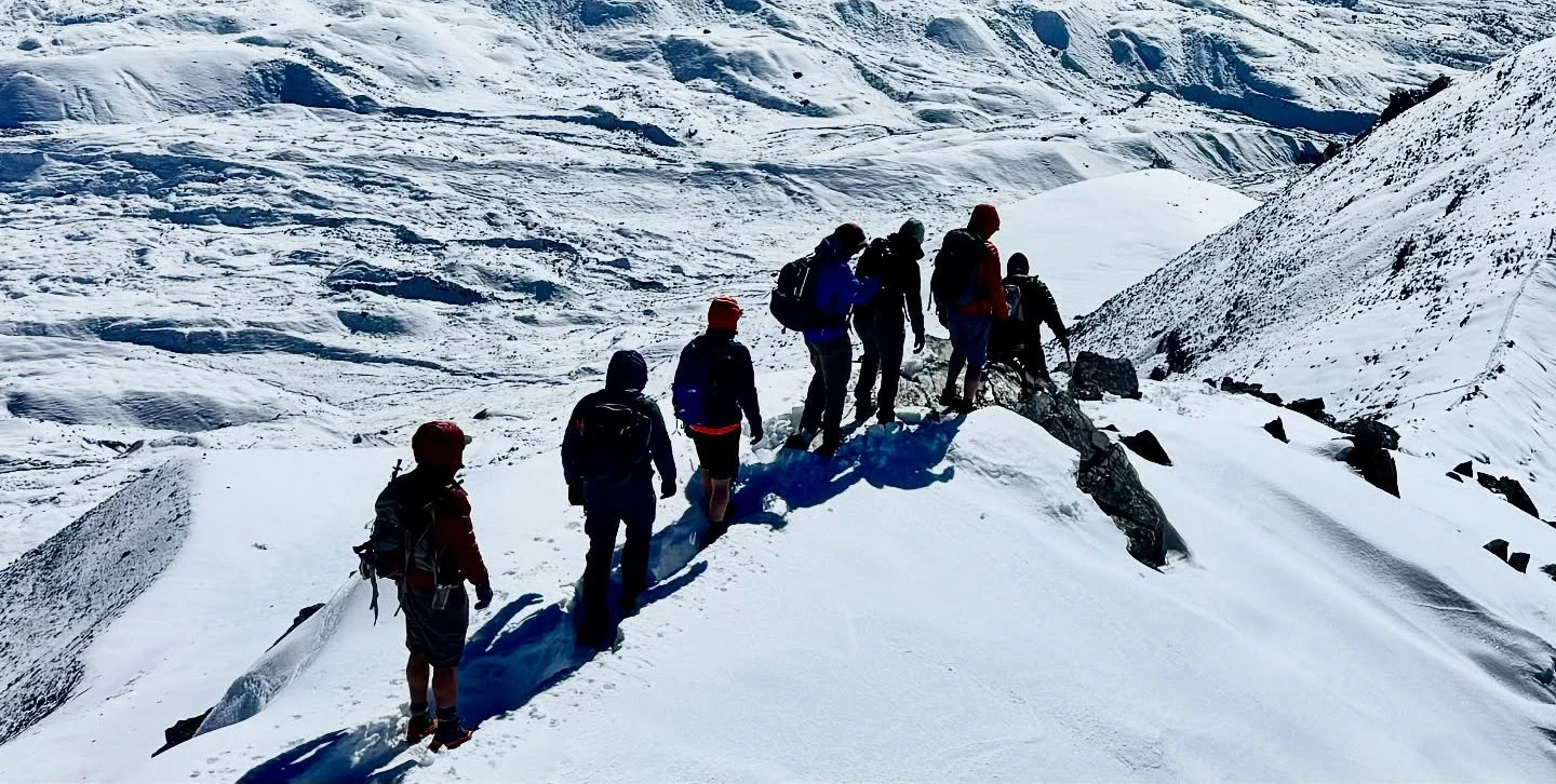
It is fundamentally a massive, steeply-tilted mountain composed of loose gravel, large boulders, rocky moraines, and seasonal snow patches.
This makes it accessible to physically fit trekkers who do not possess advanced technical mountaineering certifications (like Basic or Advanced Mountaineering Courses) but want to experience true high-altitude mountaineering.
2. Strategic Location in the Rain-Shadow Lahaul Region
Situated near the famous Baralacha La Pass on the Manali-Leh Highway, Yunam Peak benefits from Lahaul’s unique geography. Because it lies in a rain-shadow zone, the region remains relatively shielded from the heavy monsoon downpours that lash the outer Himalayan ranges (like Pir Panjal or Dhauladhar) during July and August. While lower regions experience heavy rains, the approach to Yunam stays comparatively dry, making it one of the very few viable 6,000-meter peaks to climb during the peak summer and monsoon months.
3. Gateway for Advanced Expeditions (Stok Kangri Alternative)
Following the closure or regulatory changes surrounding iconic entry-level 6,000-meter peaks like Stok Kangri in Ladakh, the mountaineering community actively searched for a worthy substitute. Yunam Peak naturally stepped into this role. It serves as an ideal training ground for mountaineers planning to tackle much tougher, highly technical expeditions later in their lives, such as:
Kang Yatse I & II
Mentok Kangri
Friendship Peak / Deo Tibba
4. Raw Trans-Himalayan Scenery and Dark Skies
The visual landscape surrounding Yunam Peak is raw, dramatic, and intensely photogenic. From the summit ridge, climbers are treated to a 360-degree spectacle of:
The rugged, snow-dusted peaks of the Chandra-Bhaga (CB) and Mulkilla ranges.
The distant, jagged horizons of the Zanskar and Spiti ranges.
High-altitude pristine water bodies like Suraj Tal and Deepak Tal gleaming far down in the valleys.
Furthermore, the base camps near Bharatpur feature Class 1 Dark Skies, making it an absolute paradise for astrophotography and stargazing.
Yunam Peak Expedition Complete Guide
Our mission has always been to ensure that no trekker steps into the Himalayas without the right perspective. A trek is not just a checklist of summits; it is a serious commitment to the outdoors. Having the right information is what separates a reckless climb from a soulful journey.
This section serves as your definitive manual for the Yunam Peak Expedition. We have distilled years of mountain experience and real-time feedback into this guide to give you a clear, honest picture of the trail.
We provide this depth of information because we want you to be more than just a visitor—we want you to be a prepared, responsible trekker who respects the mountains as much as we do.
Day 1: Arrival in Manali (1,960m) – Gear check, briefing, and overnight stay.
Day 2: Manali to Jispa (3,200m) via Atal Tunnel – Drive through Lahaul Valley; evening acclimatization walk.
Day 3: Jispa to Bharatpur Base Camp (4,500m) via Baralacha La – Drive past Suraj Tal; base camp setup and basic technical orientation.
Day 4: Acclimatization Day at Bharatpur (4,500m) – Rotation hike up to 4,900m and back to base camp for rest and hydration.
Day 5: Bharatpur Base Camp to Summit Camp (5,300m) – Trek over moraines and boulder fields; early rest and dinner.
Day 6: Rest and Summit Preparation at Summit Camp (5,300m) – Light camp walk, gear check, and early sleep by 6:00 PM.
Day 7: Summit Push (6,111m) & Descent to Base Camp (4,500m) – Midnight start (2:00 AM), climb across scree and ridges to the summit, then descend back to base camp.
Day 8: Bharatpur Base Camp to Manali – Drive back across Baralacha La and Atal Tunnel, ending the expedition with certificate distribution in Manali.
Day 1
Day 2
Day 3
Day 4
Day 5
Day 6
Day 7
Day 8
Day 1: Arrival in Manali and Expedition Briefing
Altitude: 1,960 meters (6,430 feet)
Activity: Arrive in Manali and check into your designated base hotel or campsite. Take the first half of the day to rest and recover from your travel fatigue. In the afternoon, undergo mandatory medical checks (blood oxygen saturation, pulse rate, and general health evaluation).
Evening Briefing: Meet your expedition leader and technical guides. This session covers gear inspection, fitting of technical equipment, team introductions, and an overview of the high-altitude protocols for the days ahead.
Overnight Stay: Hotel or campsite in Manali.
Day 2: Drive from Manali to Jispa via Atal Tunnel and Keylong
Altitude: 3,200 meters (10,500 feet)
Drive Distance: 85 km (3 to 4 hours)
Activity: After an early breakfast, board your expedition vehicles and drive out of Manali. Pass through the engineering marvel of the Atal Tunnel, which immediately transports you into the arid, striking rain-shadow landscape of the Lahaul Valley. Drive along the gushing Chandra and Bhaga rivers, passing through tribal hamlets, traditional stone villages, and Keylong.
Acclimatization Focus: Arrive in Jispa by afternoon. Spend the evening taking a slow, active walk around the valley floor to let your lungs adjust to the sudden jump in elevation.
Overnight Stay: Riverside camp or hotel in Jispa.
Day 3: Jispa to Bharatpur Base Camp via Baralacha La
Altitude: 4,500 meters (14,760 feet)
Drive Distance: 55 km (2.5 to 3 hours)
Activity: Hit the Manali-Leh Highway early in the morning. The drive takes you past picturesque high-altitude wetlands, Deepak Tal, and the pristine blue waters of Suraj Tal (the source of the Bhaga River). Continue ascending until you cross the high mountain pass of Baralacha La (4,850m). Descend slightly on the other side to reach Bharatpur Base Camp, situated directly at the foothills of Yunam Peak.
Camp Life: Set up camp. Post-lunch, your guides will conduct a practical training session on snow and ice craft (if required), proper walking techniques on loose scree, and how to handle trekking poles safely.
Overnight Stay: Base camp tents.
Day 4: Active Acclimatization and Rotation Hike at Bharatpur
Altitude: 4,500 meters (Base Camp) touching 4,900 meters during the hike
Activity: A crucial day dedicated entirely to physiological acclimatization. After a hearty breakfast, embark on a steady acclimatization hike up the lower slopes of the mountain. You will climb up to around 4,900 meters before hiking back down to base camp for lunch.
Focus: This "climb high, sleep low" strategy triggers red blood cell production. Spend the afternoon hydrating heavily, resting, and checking your summit layers and gear.
Overnight Stay: Base camp tents.
Day 5: Bharatpur Base Camp to Summit Camp
Altitude: 5,300 meters (17,380 feet)
Trek Distance & Time: 4 km (3 to 4 hours of steady climbing)
Activity: Leave base camp in the morning after breakfast. The trail involves navigating tricky moraines, erratic boulders, and crossing small glacial streams. The path gets progressively steeper as you gain altitude.
Setting Camp: Reach Summit Camp by early afternoon. Because wind speeds are much higher here, tents are securely pitched behind natural rock barriers. Rest early, hydrate continuously, and consume a light, early dinner to prepare for the midnight push.
Overnight Stay: High-altitude expedition tents at Summit Camp.
Day 6: Rest, Final Summit Briefing, and Early Sleep
Altitude: 5,300 meters (17,380 feet)
Activity: Keep this day light to conserve maximum energy. Enjoy a relaxed morning, followed by a short, slow walk around the camp perimeter just to keep the blood flowing.
Afternoon Prep: Organize your summit pack, test your headlamps, check batteries (which drain fast in sub-zero cold), and lay out your heavy down jackets, technical gloves, and balaclavas.
Early Night: Sleep by 6:00 PM, as you will be waking up in the middle of the night for the summit attempt.
Overnight Stay: Summit Camp tents.
Day 7: The Summit Push (Yunam Peak Peak) & Descent to Base Camp
Altitudes: Summit Camp (5,300m) to Yunam Peak Summit (6,111m / 20,049 feet) and descent down to Base Camp (4,500m)
Trek Time: 10 to 12 hours total
The Push: Wake up at 1:00 AM. After a cup of warm tea and light snacks, step out into the freezing dark by 2:00 AM. Guided by the beam of your headlamps, begin the grueling climb over steep, frozen scree fields and patches of hard-packed snow. The winds are sharp, and temperatures can drop to -15C or lower.
The Summit: As dawn breaks, watch the sun paint the Zanskar and Pir Panjal ranges in golden hues. Make your final push across the ridge to step onto the flat summit plateau of Yunam Peak (6,111 meters). Celebrate your milestone, capture photographs, and begin the long, careful descent back down to Summit Camp, and further down to Bharatpur Base Camp.
Overnight Stay: Base camp tents.
Day 8: Base Camp to Manali & Expedition Conclusion
Drive Distance: 140 km (5 to 6 hours)
Activity: Pack up camp after breakfast. Board your transport vehicles for the return journey across Baralacha La, through the Atal Tunnel, and back into the green valleys of Manali.
Conclusion: Arrive in Manali by late afternoon. Gather for a final expedition debriefing session, receive your official summit completion certificates, and bid farewell to your mountain guides and fellow climbers.
Departure: You can plan your onward night bus or travel out of Manali post 6:00 PM.
No difficulty level available.
Best Time to Visit Yunam Peak (6,111m)
The absolute best window to climb Yunam Peak is during the summer and early autumn months: from July to September.
The unique regional weather patterns and seasonal conditions dictate why this specific window works best:
1. July to August (The Peak Summer & Monsoon Window)
Why it works: While the rest of India experiences heavy monsoon rains, the Lahaul region (situated in the rain-shadow zone behind the Pir Panjal range) remains relatively dry and shielded.
Conditions: Days are generally clear with pleasant daytime temperatures at lower camps, though nights remain sub-zero. This makes July and August the most popular months for commercial expeditions.
2. September (The Post-Monsoon / Autumn Window)
Why it works: September brings crystal-clear blue skies, highly stable weather patterns, and exceptional visibility for photography and panoramic views from the summit.
Conditions: Temperatures start dropping sharply, and early snowfalls can occasionally dust the upper ridges, but it offers some of the most stable climbing days of the entire year.
Avoid These Months:
October to June: The region experiences extreme winters, heavy snowfall, and blocked mountain passes (like Baralacha La and the approaches to Lahaul). Temperatures plunge to dangerous levels making the peak inaccessible for standard expeditions.
To reach Manali for your expedition base camp, Himalayan Hikers
1. Reaching Manali by Road (Most Popular & Reliable)
Most travelers and trekkers prefer traveling by road to Manali as it offers direct connectivity and scenic views.
From Delhi (Distance: 540 km | Time: 12 to 14 hours):
Head to ISBT Kashmiri Gate or Majnu-ka-Tilla in Delhi.
Book an overnight Volvo AC bus or HRTC (Himachal Road Transport Corporation) bus directly to Manali. Booking these tickets online a few days in advance is strongly advised.
From Chandigarh (Distance: 300 km | Time: 7 to 9 hours):
Arrive at the Sector 43 Bus Stand in Chandigarh.
Regular government and private buses, as well as shared or private taxis, operate frequently to Manali throughout the day and night.
2. Reaching Manali by Air
Nearest Airport: Bhuntar Airport (Kullu-Manali Airport), located roughly 50 km away from Manali.
How to proceed: Flights to Bhuntar are limited and heavily dependent on weather conditions. Once you land at Bhuntar, you can easily hire pre-paid local taxis or board a bus outside the terminal to reach Manali (about a 1.5 to 2-hour drive).
Alternative: Many travelers prefer flying into major hubs like Delhi or Chandigarh and taking an overnight bus/cab.
3. Reaching Manali by Train
Manali does not have its own direct railway station.
Chandigarh Railway Station is the most preferred railhead because it connects well to major cities across India. From the railway station, you can take local transport to the Sector 43 Bus Stand and catch a bus or cab heading to Manali
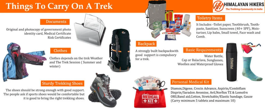
Necessary Items for trekkers
Mandatory Documents
Original and photocopy of government photo identity card- (Aadhar Card, Driving License, Voters ID, etc,)
Passport and Visa important to foreigners
Medical Certificate (First part should be filled by the Doctor and Second part by the Trekker)
Declaration Certificates
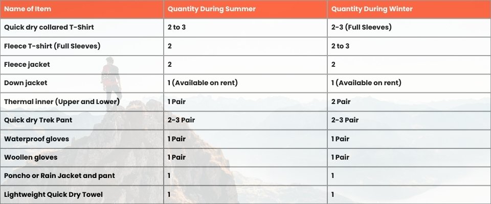
Note: – Many trekkers commit the same mistake of carrying unnecessary items on a trek which only makes the backpack heavy. It is important to know the right items to carry. It differs from season to season if you are trekking in summers then carry less layers of warm clothing and if you are trekking in winters carry enough layers to protect yourself against chilly cold.
Basic Trekking Gears
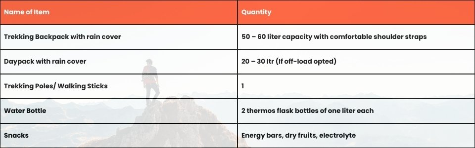
The Clothes You Should Bring On Satopanth Expedition
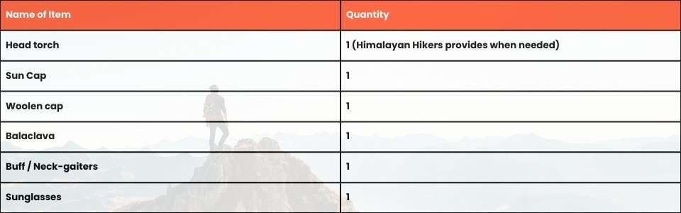
Head Gears
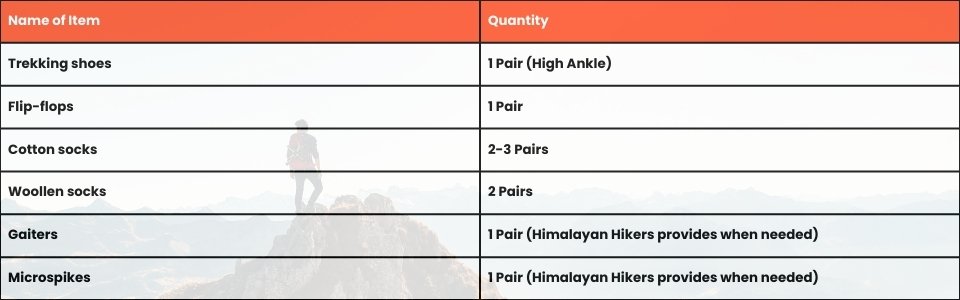
Foot Gears
Personal Care Essentials

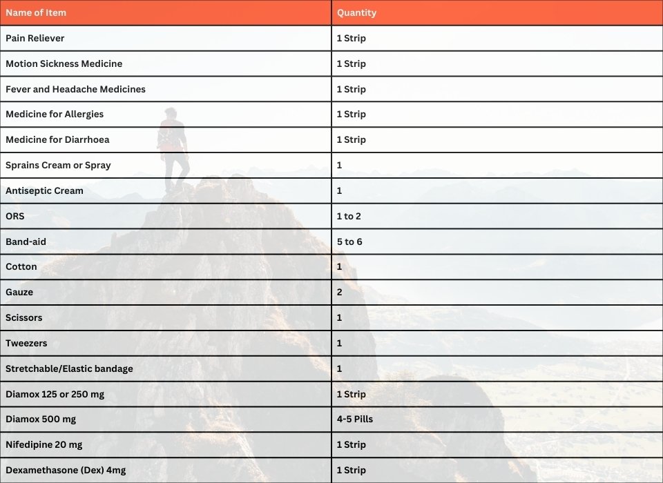
Carry a Personal Medical Kit
Are you Looking for Trekking Equipment on Rent?
If any trekker requires trekking equipment on rent, Himalayan Hikers offers the best-quality gear available for rental. Many individuals are in need of such equipment, and renting provides a cost-effective solution, allowing them to access high-quality gear at an affordable price without the need for a significant investment for short-term use.
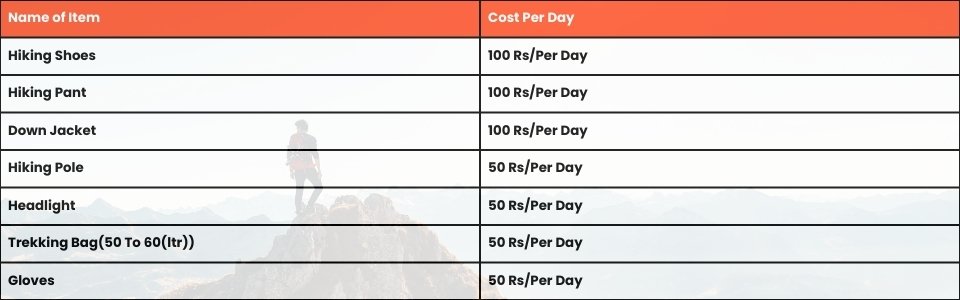
Trek Equipment You can book directly on first day at the Base Camp.
Note:-
Please take all medicines only when prescribed by the doctor. In case you face any problem during your trek,
discuss and take advice from the Professional guide.
The Trek is one of the most popular treks in Uttarakhand, Himachal,Kashmir,Laddakh,Sikkim,Nepal, requiring both physical preparation and mental readiness. Although it is categorized as a moderate trek, reaches an elevation of over 12,720 feet and traverses remote Himalayan terrain, which can be physically and mentally challenging. Here's how you can prepare yourself for a safe and successful accomplishment of the Trek:
Physical Fitness
Building a good fitness base is essential for every trekker. The Trek itinerary involves 5 to 6 hours of walking every day. Though the trails are well-marked, they are often bumpy and include steep uphill sections, which may affect your stamina. You can overcome your physical limitation with a 6-week training program that you can begin about 2 months before your Trek. Your 6-week fitness routine should include

Pro Tip: If you have time, you can skip the Sunday training and go for a long-distance walk or mini day-hike (7–10 km) with a loaded backpack to simulate real trekking conditions. A short 1-day hike around your city/town can help a lot.
Mental Preparation
Physical strength is only half the journey, the other half is mental resilience. The trail takes you through remote clearings, steep climbs, cold starry nights, and no mobile connectivity. Be prepared to:
(I) - Detach from the digital world.
(II) - Embrace basic mountain living (camping, toilet tents, limited electricity).
(III) - Push through moments of fatigue, weather discomfort, or altitude effects.
A positive mindset, patience, and the ability to adapt will carry you farther than muscle ever could.Himalayan Hikers is a reputable trekking company that places a high priority on safety. Here are some of the safety measures they take to ensure the safety of their clients during the Trek:
Experienced Guides: Himalayan Hikers hires experienced and certified guides who are well-versed in the terrain, weather conditions, and local culture. These guides have first-hand knowledge of the routes and are equipped to handle any emergency situations that may arise.
Proper Gear: The company provides all the necessary gear and equipment to their clients to ensure comfort and safety during the trek.
Hygiene and Sanitation: Himalayan Hikers places great emphasis on hygiene and sanitation during the Trek. They provide clean drinking water, hand sanitizers, and toilet tents to ensure that their clients are healthy and comfortable.
Emergency Services: The company has a well-defined protocol for handling emergency situations. They have a team of trained medical professionals who are available 24/7 and can be quickly mobilized in case of an emergency.
Acclimatization: Himalayan Hikers follows a gradual acclimatization process during treks to ensure that their clients adjust to the high altitude gradually. They also monitor the health of their clients regularly and provide necessary medical attention if required.
Overall, Himalayan Hikers places a great emphasis on safety and takes all necessary measures to ensure the safety and well-being of their clients during treks.
No inclusions found.
No exclusions found.
Important Note
No important note.
Map not available for this trek.
Lahaul region of Himachal Pradesh, near Baralacha La pass.
It stands at an elevation of 6,111 meters (20,049 feet).
No, it is a non-technical peak involving scree and boulder walking.
July to September is the ideal summer and post-monsoon window.
t is a complete 8-day expedition starting and ending in Manali.
High cardiovascular endurance and ability to run 5-10 km easily.
Previous high-altitude trekking experience (around 4,000m-5,000m) is strongly recommended.
By overnight Volvo bus or taxi from Delhi and Chandigarh.
Nights at high camps drop sharply to negative 15°C or lower.
Yes, proper acclimatization and hydration are vital to prevent altitude sickness.


