


The Swargarohini trek via Badrinath is an adventurous journey that takes you through the picturesque landscapes of the Garhwal Himalayas in Uttarakhand, India. Here are the details regarding the history, location, and altitude of the Swargarohini trek via Badrinath:
- History: The Swargarohini trek has historical and mythological significance. According to Hindu mythology, it is believed that the Pandavas, from the epic Mahabharata, ascended to heaven (Swarga) from this region. Swargarohini, which means “the path to heaven,” is named after this mythological event. The trekking route has been frequented by pilgrims and trekkers for centuries, offering an opportunity to experience the beauty of the Himalayas and connect with nature.
- Location: The trek via Badrinath typically starts from the town of Badrinath, a revered Hindu pilgrimage site situated in the Chamoli district of Uttarakhand. Badrinath is nestled in the Garhwal Himalayas at an altitude of approximately 3,100 meters (10,170 feet) above sea level. It is surrounded by snow-capped peaks and lush green valleys, making it an ideal base for various treks, including the Swargarohini trek.
- Altitude: The altitude of the Swargarohini trek via Badrinath varies throughout the journey. The highest point of the trek is Swargarohini Peak itself, which stands at an elevation of approximately 6,252 meters (20,512 feet) above sea level. However, the trek involves ascending and descending through different altitudes, including alpine meadows, forests, and high passes. Trekkers usually camp at various altitudes along the route, acclimatizing themselves to the changing elevation.
- Route: The route from Badrinath typically follows a path that passes through Mana Village, the last inhabited village near the Indo-Tibetan border. From Mana Village, trekkers proceed towards Vasudhara Falls, a majestic waterfall believed to have connections to Hindu mythology. After enjoying the beauty of Vasudhara Falls, the trek continues towards Swargarohini Base Camp, offering panoramic views of the surrounding Himalayan peaks. Finally, trekkers attempt to summit Swargarohini Peak, which requires technical skills and proper equipment due to its high altitude and challenging terrain.
Overall, the Swargarohini trek via Badrinath offers a blend of natural beauty, cultural heritage, and spiritual significance, making it a memorable and rewarding adventure for trekkers seeking to explore the Himalayas.
History of Swargarohini Trek
According to the legends, Pandavas took this route while their ascent to heaven. Only Yudhishthira (one Pandavas) and a dog were able to reach heaven. All the other Pandavas died on the way.
As per legends belief, Swargarohini is the only path from where one Can Reach Heaven in Human form.
Satopanth, the sacred lake lies Chaukhamba massifs. It believed that Lord Brahma, Vishnu, and Mahesh took a bath in the waters of this Lake, so it is considered holy and pure.
Devotees believe that a holy dip in Satopanth Lake will wash away so every year thousands of people visit this place.
Pass-Through These Picturesque Places in Swargarohini Trek
The starting point of this trek is Mana, and the trail further leads to famous Vasudhara followed by crossing a glacier named “Dhano.” Pass through Laxmi Van which is a thick forest, en route are caves where saints live permanently.
Ahead reach the serene Satopanth Lake and spend time in the divine vicinity. Further, lie Chandrakund and Suryakund with a different mythical story.
About Base camp Joshimath in Swargarohini Trek
It is a picturesque town in Chamoli at an altitude of 1875 m nestled amid high Himalayan peaks. It is the base camp of 10 above Himalayan Treks and the gateway to famous pilgrim sites like Badrinath Dham and Hemkund Sahib Ji.
There is spirituality in the air because of the presence of ancient temples. It is home to one of the four “Math” “Atharva Veda” by Adi Shankar Acharya.
Joshimath has tranquil charm away from the cacophony of cities.
The gushing rivers and silent streams with the cover of verdant green and the pious ancient temples in the area will surely lure you to come here again and again.
Why To Choose Swargarohini Trek?
Before heading towards the itinerary, it is really essential to perceive the reason behind choosing Swargarohini Trek.
See firstly, the trekking distance is a total of by taxi 680 Km both side and on foot 78 km which is to be covered into 13 days. Dehradun to Dehradun
Swargarohini Trek is a high altitude mountain trek Altitudes is 17,987 feet
The Starting trail is moderate as compare to other treks this is difficult trek. So this trek is not for beginners
Need proper gear & clothing for sub-zero temperature?
You got to see so many heavenly bodies at one place like the panoramic view of the Himalayan ranges, you can see pine forests, different variety of flora and fauna surpassing through bona fide Garhwali culture.
I think Do spare time in Interaction with our local’s team, and you will get to know about some of the ancient Tales of Indian mythology and our local cultures, this is good ideas for trekkers
The backpack should not exceed 12 kg only
Trekker carry your Photo ID , Adhar card , Passport , Visa , medical certificate, Trek insurance for entry at forest check posts on the trek it is very important
Alcohol and non-Veg and smoking is not allowed in during the trek
Swargarohini Trek Complete Guide
Our mission has always been to ensure that no trekker steps into the Himalayas without the right perspective. A trek is not just a checklist of summits; it is a serious commitment to the outdoors. Having the right information is what separates a reckless climb from a soulful journey.
This section serves as your definitive manual for the Swargarohini Trek. We have distilled years of mountain experience and real-time feedback into this guide to give you a clear, honest picture of the trail.
We provide this depth of information because we want you to be more than just a visitor—we want you to be a prepared, responsible trekker who respects the mountains as much as we do.
Day 1– Drive from Dehradun to Joshimath Altitude – Joshimath by Taxi
Altitude: 1,875 m/ 6152 feet | Drive Distance: 256 km | Drive Duration: 10/11 Hrs | Trek Difficulty: Moderate | Overnight Stay: Hotel
Day 2- Drive from Joshimath to Badrinath by Taxi
Drive Distance: 48 km | Drive Duration: 2/3 Hrs | Trek Difficulty: Moderate | Overnight Stay: Hotel
Day 3- Trek from Badrinath to Laxmivan
Altitude: 12,510 feet | Trek Distance: 08 km | Trek Duration: 4/5 Hrs | Trek Difficulty: Moderate | Overnight Stay: Camp
Day 4- Trek from Laxmivan to Chakratirth
Altitude: 13,655 feet | Trek Distance: 10 km | Trek Duration: 5/6 Hrs | Trek Difficulty: Moderate | Overnight Stay: Camp
Day 5- Trek from Chakratirth to Satopanth Tal
Altitude: 14,755 feet | Trek Distance: 05 km | Trek Duration: 4/5 Hrs | Trek Difficulty: Moderate | Overnight Stay: Camp
Day 6- Trek from Satopanth Tal to Chandrakund Trek
Altitude: 16,578 feet | Trek Distance: 06 km | Trek Duration: 5/6 Hrs | Trek Difficulty: Difficult | Overnight Stay: Camp
Day 7- Trek from Chandrakund to Suryakund
Altitude: 17,255 feet | Trek Distance: 07 km | Trek Duration: 5/6 Hrs | Trek Difficulty: Difficult | Overnight Stay: Camp
Day 8- Acclimatization Day
Day 9- Trek from Suryakund to Swargarohini Base Camp
Altitude: 17987 feet | Trek Distance: 06 km | Trek Duration: 6/7 Hrs | Trek Difficulty: Difficult | Overnight Stay: Camp
Day 10 – Trek from Suryakund to Satopanth Tal
Altitude: 14,755 feet | Trek Distance: 13 km | Trek Duration: 7/8 Hrs | Trek Difficulty: Difficult | Overnight Stay: Camp
Day 11- Trek from Satopanth Tal to Laxmivan
Altitude: 12,510 feet | Trek Distance: 15 km | Trek Duration: 7/8 Hrs | Trek Difficulty: Moderate | Overnight Stay: Camp
Day 12- Trek from Laxmivan to Badrinath
Drive Distance: 8 km | Trek Duration: 4/5 Hrs |Trek Difficulty: Moderate | Overnight Stay: Hotel
Day 13- Trek from Badrinath to Dehradun by Taxi
Drive Distance: 380 km | Drive Duration: 11/12 Hrs | Trek Difficulty: Moderate
Day 1
Day 2
Day 3
Day 4
Day 5
Day 6
Day 7
Day 8
Day 9
Day 10
Day 11
Day 12
Day 13
Day 1– Drive from Dehradun to Joshimath Altitude – Joshimath by Taxi
Altitude: 1,875 m/ 6152 feet | Drive Distance: 256 km | Drive Duration: 10/11 Hrs | Trek Difficulty: Moderate | Overnight Stay: Hotel
Himalayan Hikers organizes transport for trekkers from Haridwar Railway Station in the morning which will leave for Sankri around 6:00 am to 7:00 am.
Today start your journey with team Himalayan Hikers from
Haridwar,
The drive to Joshimath is 10/11 hours long, along the sacred rivers –
Alaknanda, Mandakini and Ganga. Devprayag is en route at the confluence of
river Bhagirathi and Alaknanda. This is beautiful place
The journey won’t get boring because there are sudden changes in the scenery as
you go further.
Reach Joshimath base camp , relax in a hotel, in the evening you can explore nearby areas. Get back, have dinner and enjoy comfortable stay in the hotel.
Day 2- Drive from Joshimath to Badrinath by Taxi
Drive Distance: 48 km | Drive Duration: 2/3 Hrs | Trek Difficulty: Moderate | Overnight Stay: Hotel
After breakfast drive to Badrinath – check –in hotel explore day at Badrinath join evening arti darshan – dinner overnight stay hotel.
Day 3- Trek from Badrinath to Laxmivan
Altitude: 12,510 feet | Trek Distance: 08 km | Trek Duration: 4/5 Hrs | Trek Difficulty: Moderate | Overnight Stay: Camp
Post breakfast the drive is towards the last village Mana, trek starts from there. After a short trek you will get the sight of Vasudhara falls which lies opposite Alaknanda River’s bank. Ascent gradually till Somtoli meadows and cross landslide prone area, now shepherd huts are visible.
Go through boulder zone to reach the campsite, there are Bhojpatra trees in abundance. The surroundings are beautiful with sight of Alkapuri glacier which lies on the opposite side. Setup your camps and retire for the night.
Day 4- Trek from Laxmivan to Chakratirth
Altitude: 13,655 feet | Trek Distance: 10 km | Trek Duration: 5/6 Hrs | Trek Difficulty: Moderate | Overnight Stay: Camp
The trek is challenging today, head from Laxmi Van towards Chakrateerth. The ascent is sheer through scree and boulders to “Sahastradhara” which means “Thousand waterfalls”. After you climb up the valley this place offer views of Chaukhamba peaks, Balakun and Neelkanth.
Ahead cross a narrow stream and walk on the levelled ground. Now, start the steep climb, now a short trek will lead you to Chakrateerth campsite. Setup your camps and retire for the night.
Day 5- Trek from Chakratirth to Satopanth Tal
Altitude: 14,755 feet | Trek Distance: 05 km | Trek Duration: 4/5 Hrs | Trek Difficulty: Moderate | Overnight Stay: Camp
Start the trek early today because you will be crossing some tricky sections on the trail. Ascent to the ridge’s high point and trek along the glacier to reach serene triangular “Satopanth Lake”. Get impressive views of Chaukhamba peaks and Neelkanth Mahadev.
The surroundings are beautiful, explore and relax there for some time. Setup your tents there and retire for the night.
Day 6- Trek from Satopanth Tal to Chandrakund Trek
Altitude: 16,578 feet | Trek Distance: 06 km | Trek Duration: 5/6 Hrs | Trek Difficulty: Difficult | Overnight Stay: Camp
Wake up and witness the Chaukhamba peaks turning golden at
the time of sunrise. After breakfast start the trek towards Chandrakund and see
some rooms made of stones where saints live permanently.
The trail gets narrow and on one side is crevassed Satopanth glacier and on
other side is the barren land. Walk very carefully while crossing this region
because a single mistake can be very dangerous.
Reach Chandartal, it is a small Lake where the water level increases and decreases from time to time. It is believed that Lord Chandrama meditated here and at the day of Purnima (full moon night) this Lake remains full of water.
Day 7- Trek from Chandrakund to Suryakund
Altitude: 17,255 feet | Trek Distance: 07 km | Trek Duration: 5/6 Hrs | Trek Difficulty: Difficult | Overnight Stay: Camp
Start the day early and head towards Suryakund, walk on the edge of mountain, go through the moraine area and boulder zone. Get the clear view of entire Chaukhamba peaks and Kuber Parvat. Setup your camps and retire for the night.
Day 8- Acclimatization Day
Today go for short hikes, explore the area and rest for the day. Enjoy the night here.
Day 9- Trek from Suryakund to Swargarohini Base Camp
Altitude: 17987 feet | Trek Distance: 06 km | Trek Duration: 6/7 Hrs | Trek Difficulty: Difficult | Overnight Stay: Camp
From Suryakund to Swargarohini Glacier, it is a steep incline and on the way are crevasses. The trek through boulder and moraine area is a tough one but the excellent and close views of high peaks are totally rewarding.
Reach the Swargarohini Glacier, above lies Swargarohini peaks “Char Singh” “Way to Heaven”. From here 3 steps of stairs are, they are believed to be total 7 but all of them are not visible due to the clouds.
This glacier is less crevassed and is in better condition than the other glaciers. Setup your camps in a suitable place, have food and retire for the night.
Day 10 – Trek from Suryakund to Satopanth Tal
Altitude: 14,755 feet | Trek Distance: 13 km | Trek Duration: 7/8 Hrs | Trek Difficulty: Difficult | Overnight Stay: Camp
After breakfast follow the same route and get back to this mystical Lake. Satopanth Tal overnight stay camp.
Day 11- Trek from Satopanth Tal to Laxmivan
Altitude: 12,510 feet | Trek Distance: 15 km | Trek Duration: 7/8 Hrs | Trek Difficulty: Moderate | Overnight Stay: Camp
Get back to Laxmivan via Chakrateerth, descending takes less time but be careful while the descent because some sections are tricky.
Day 12- Trek from Laxmivan to Badrinath
Drive Distance: 8 km | Trek Duration: 4/5 Hrs |Trek Difficulty: Moderate | Overnight Stay: Hotel
Descent towards Mana village and you can reach there in 3 hours. From Mana the drive is towards Badrinath, arrangements will be made in a hotel there. Evening going to Badrinath ji darshan
13- Trek from Badrinath to Dehradun by Taxi
Drive Distance: 380 km | Drive Duration: 11/12 Hrs | Trek Difficulty: Moderate
Post breakfast leave for Dehradun, have your lunch en route and reach there in the evening. 8 pm
The Satopanth Swargarohini Trek is considered to be of a moderate to difficult level. Here’s why:
- Altitude: The trek involves reaching high altitudes, with Satopanth Lake located at an altitude of around 4,600 meters (15,092 feet) above sea level. Altitude sickness can be a concern for trekkers not acclimatized to high altitudes.
- Terrain: The terrain is rugged and challenging, with steep ascents and descents, rocky paths, moraines, and sometimes snow-covered sections, especially in higher altitudes. Trekkers need to have good physical fitness and stamina to navigate these terrains.
- Duration: The trek usually takes around 12-13 days to complete, depending on the specific itinerary chosen. Long trekking days, sometimes spanning 6-8 hours or more, require endurance and stamina.
- Weather: Weather conditions in the Himalayas can be unpredictable, with rapid changes in weather patterns. Trekkers may encounter rain, snow, or strong winds, especially at higher altitudes, adding to the difficulty of the trek.
- Remote Location: The trek takes place in a remote and isolated region of the Garhwal Himalayas, with limited access to facilities and services. Trekkers need to be self-sufficient and prepared for any emergencies that may arise.
Overall, while the Satopanth Swargarohini trek offers breathtaking views of the Himalayan peaks and a sense of adventure, it requires careful planning, physical fitness, and mental preparedness to overcome the challenges associated with high-altitude trekking in a remote wilderness setting.
No best time available.
How to reach for Satopnath Swargarohini Trek ?
The Satopanth Swargarohini trek is a challenging trek in the Garhwal Himalayas, known for its stunning views and spiritual significance. To reach the starting point of this trek, you’ll typically need to travel to Mana Village, which serves as the base camp for the Satopanth trek. Here’s how you can reach Mana Village:
From Dehradun:
- By Road:
- Dehradun is well-connected by road to Joshimath. From Joshimath, you can hire a taxi or take a shared jeep to reach Mana Village. The journey from Joshimath to Mana Village takes around 2-3 hours by road.
- By Air and Road:
- If you’re coming from outside Uttarakhand, you can take a flight to the Jolly Grant Airport in Dehradun. From the airport, you can either hire a taxi directly to Joshimath or take a taxi/bus to the Dehradun ISBT (Inter-State Bus Terminal) and then catch a bus/shared jeep to Joshimath.
From Badrinath:
- By Road:
- Badrinath is located near Mana Village, so you can hire a taxi or take a shared jeep directly from Badrinath to Mana Village. The distance is short, and the journey takes around 30 minutes to 1 hour depending on road conditions.
Important Tips:
- Local Transport: From Mana Village, you’ll start your trek towards Satopanth Lake. You can arrange for a guide/porter from Mana Village itself.
- Permits and Regulations: Ensure you have the necessary permits for trekking in the area. Check with local authorities or tour operators for the latest regulations.
- Weather Conditions: The weather in the Himalayas can be unpredictable, so make sure to check the weather forecast before starting your trek.
- Physical Fitness: The Satopanth Swargarohini trek is challenging and involves steep ascents and descents. Ensure you’re physically fit and prepared for the trekking challenges.
- Equipment and Supplies: Pack appropriate trekking gear, including sturdy trekking shoes, warm clothing, rain gear, and sufficient food and water for the trek.
Always double-check the current transportation options and local regulations as they may change over time. Additionally, it’s recommended to consult with experienced trekkers or local tour operators for personalized advice and assistance.
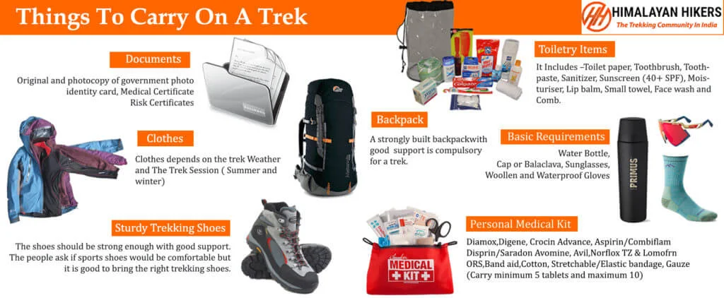
Necessary Items for trekkers
Mandatory Documents
Original and photocopy of government photo identity card- (Aadhar Card, Driving License, Voters ID, etc,)
Passport and Visa important to foreigners
Medical Certificate (First part should be filled by the Doctor and Second part by the Trekker)
Declaration Certificates
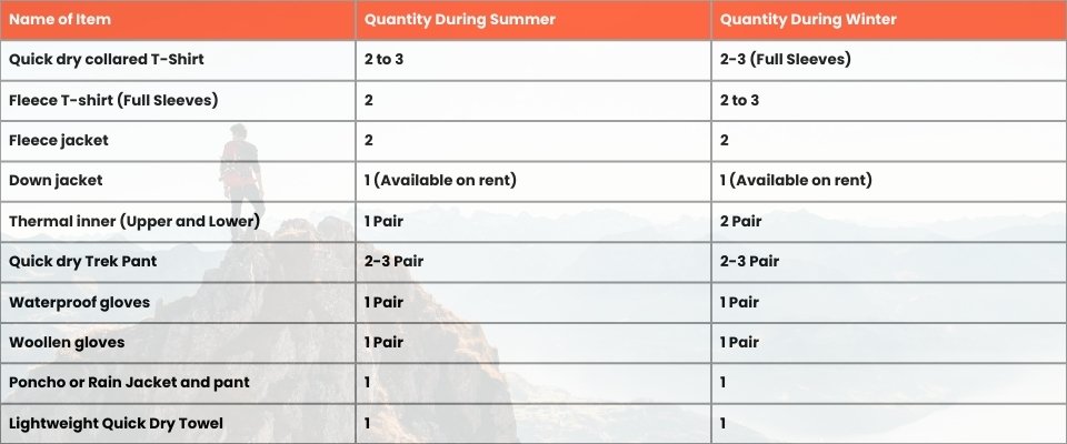
Note: – Many trekkers commit the same mistake of carrying unnecessary items on a trek which only makes the backpack heavy. It is important to know the right items to carry. It differs from season to season if you are trekking in summers then carry less layers of warm clothing and if you are trekking in winters carry enough layers to protect yourself against chilly cold.
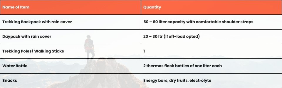
Basic Trekking Gears
The Clothes You Should Bring On Satopanth Expedition
Head Gears
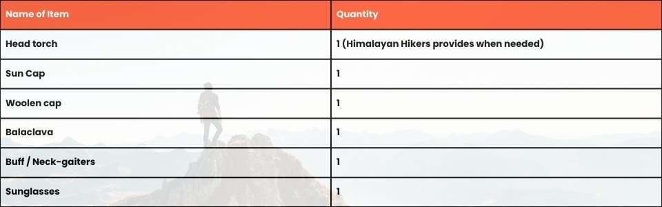
Foot Gears
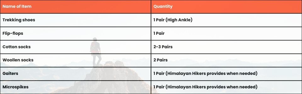
Personal Care Essentials

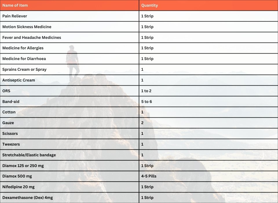
Carry a Personal Medical Kit
Are you Looking for Trekking Equipment on Rent?
If any trekker requires trekking equipment on rent, Himalayan Hikers offers the best-quality gear available for rental. Many individuals are in need of such equipment, and renting provides a cost-effective solution, allowing them to access high-quality gear at an affordable price without the need for a significant investment for short-term use.
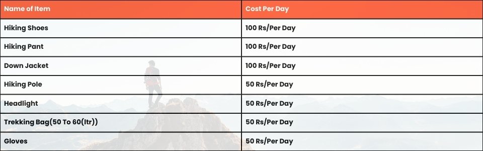
Trek Equipment You can book directly on first day at the Base Camp.
Note:-
Please take all medicines only when prescribed by the doctor. In case you face any problem during your trek,
discuss and take advice from the Professional guide.
The Trek is one of the most popular treks in Uttarakhand, Himachal,Kashmir,Laddakh,Sikkim,Nepal, requiring both physical preparation and mental readiness. Although it is categorized as a moderate trek, reaches an elevation of over 12,720 feet and traverses remote Himalayan terrain, which can be physically and mentally challenging. Here's how you can prepare yourself for a safe and successful accomplishment of the Trek:
Physical Fitness
Building a good fitness base is essential for every trekker. The Trek itinerary involves 5 to 6 hours of walking every day. Though the trails are well-marked, they are often bumpy and include steep uphill sections, which may affect your stamina. You can overcome your physical limitation with a 6-week training program that you can begin about 2 months before your Trek. Your 6-week fitness routine should include

Pro Tip: If you have time, you can skip the Sunday training and go for a long-distance walk or mini day-hike (7–10 km) with a loaded backpack to simulate real trekking conditions. A short 1-day hike around your city/town can help a lot.
Mental Preparation
Physical strength is only half the journey, the other half is mental resilience. The trail takes you through remote clearings, steep climbs, cold starry nights, and no mobile connectivity. Be prepared to:
(I) - Detach from the digital world.
(II) - Embrace basic mountain living (camping, toilet tents, limited electricity).
(III) - Push through moments of fatigue, weather discomfort, or altitude effects.
A positive mindset, patience, and the ability to adapt will carry you farther than muscle ever could.Himalayan Hikers is a reputable trekking company that places a high priority on safety. Here are some of the safety measures they take to ensure the safety of their clients during the Trek:
Experienced Guides: Himalayan Hikers hires experienced and certified guides who are well-versed in the terrain, weather conditions, and local culture. These guides have first-hand knowledge of the routes and are equipped to handle any emergency situations that may arise.
Proper Gear: The company provides all the necessary gear and equipment to their clients to ensure comfort and safety during the trek.
Hygiene and Sanitation: Himalayan Hikers places great emphasis on hygiene and sanitation during the Trek. They provide clean drinking water, hand sanitizers, and toilet tents to ensure that their clients are healthy and comfortable.
Emergency Services: The company has a well-defined protocol for handling emergency situations. They have a team of trained medical professionals who are available 24/7 and can be quickly mobilized in case of an emergency.
Acclimatization: Himalayan Hikers follows a gradual acclimatization process during treks to ensure that their clients adjust to the high altitude gradually. They also monitor the health of their clients regularly and provide necessary medical attention if required.
Overall, Himalayan Hikers places a great emphasis on safety and takes all necessary measures to ensure the safety and well-being of their clients during treks.
No inclusions found.
No exclusions found.
Important Note
No important note.
Map not available for this trek.
No FAQs available for this trek.


.webp)


