Pangarchulla Peak is located in Chamoli District of Uttarakhand and it extends from 15096 feet, Trek – A beautiful mini peak near to Kauri Pass trek in Uttarakhand.
The Pangarchulla Peak trek is a popular and challenging trek located in the Garhwal region of Uttarakhand, India. The trek offers breathtaking views of snow-capped peaks, beautiful meadows, and dense forests.
Why Choose Pangarchulla Peak Trek?
Before heading towards the itinerary, it is really essential to perceive the reason behind choosing the Pangarchulla peak trek.
- Pangarchulla Peak is a high-altitude Trek with Altitudes of 15096 feet
- The Starting trail is moderate as compared to other treks this is a difficult trek. So this trek is not for beginners
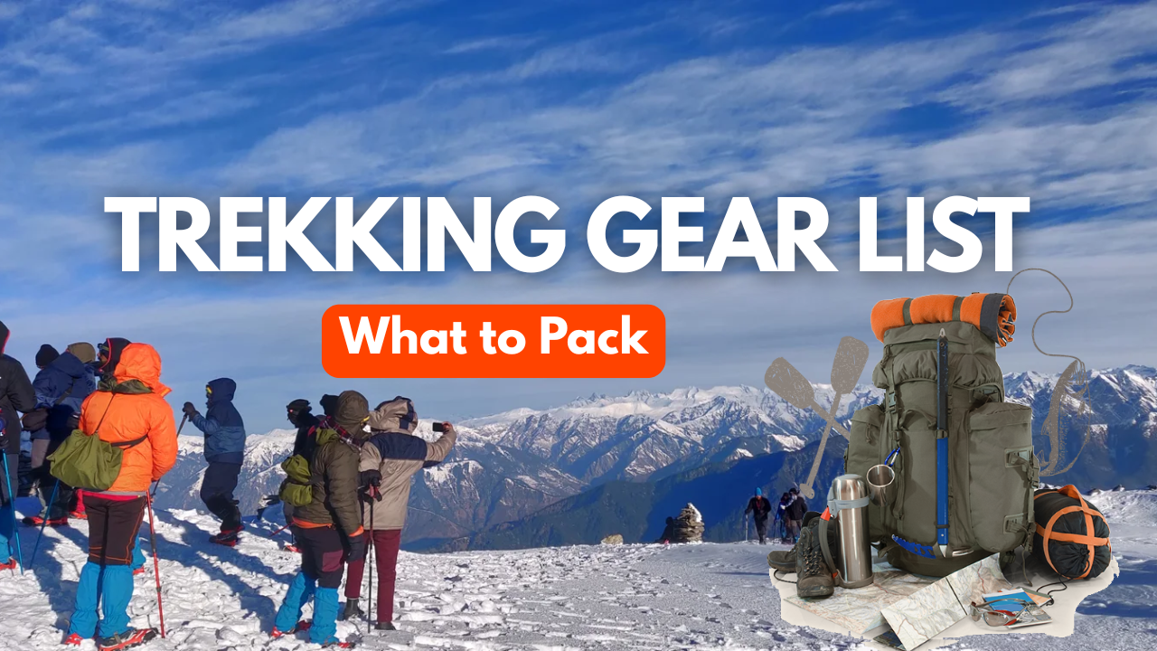
Need proper gear & clothing for sub-zero temperatures?
- You got to see so many heavenly bodies at one place like the panoramic view of the Himalayan ranges, you can see pine forests, different varieties of flora and fauna surpassing through bona fide Garhwali culture and mythology.
- I think Do spare time in Interaction with our local team, and you will get to know about some of the ancient tales of Indian mythology and our local cultures, these are good ideas for trekkers
- Beautiful landscapes so carry proper photo gear and extra battery backup.
- The backpack should not exceed 12 kg only
Here are some of the Highlights of the Pangarchulla Peak Trek:
- Stunning views: The trek offers stunning views of some of the highest peaks in India, including Nanda Devi, Kamet, and Dronagiri. You’ll also get to see beautiful meadows, glaciers, and valleys.
- Challenging terrain: The trek is challenging, and you’ll need to be in good physical condition to complete it. The trail passes through steep inclines, narrow ridges, and rocky terrain.
- Rich flora and fauna: The trek takes you through dense forests of oak, rhododendrons, and deodar trees. You’ll also get to spot various animals and birds like the Himalayan black bear, musk deer, and snow leopard.
- Cultural experience: The trek takes you through several remote villages where you can experience the local culture and interact with the friendly villagers.
- Summit of Pangarchulla Peak: The trek culminates with a climb to the summit of Pangarchulla Peak, which offers stunning 360-degree views of the surrounding mountains and valleys.
Pangarchulla Peak Trek Guide
Day 1: Drive from Dehradun via Rishikesh to Joshimath Market Base Camp
Altitude Gain: 2,089 ft to 8,530 ft | Drive Distance: 280 km | Drive Duration: 9 to 10 hours | Overnight Stay: Joshimath Hotel Dhaneesh (Twin Sharing) | Pick-up point for Himalayan Hikers trekkers: Prince Chowk, nearby Dehradun Railway Station
Route: Dehradun → Rishikesh → Devprayag → Srinagar (Garhwal) → Rudraprayag → Karnaprayag → Nandaprayag → Joshimath
Highlights
Begin your journey from Dehradun or Rishikesh with a scenic drive to Joshimath, the base camp for the Pangarchulla Peak Trek. En route, witness the sacred river confluences at Devprayag, Rudraprayag, Karnaprayag, and Vishnuprayag, each offering stunning views and cultural significance.
Day 2: Drive from Joshimath to Tugasi Village by Taxi, same day Trek to Gulling Campsite
Altitude Gain: 7,545 ft to 8,530 ft to 9,264 ft | Trek Distance: 3 km | Trek Duration: 3 to 4 hours | Trek Difficulty: Easy to Moderate | Overnight Stay: Gulling Campsite (Twin Sharing)
Highlights
Drive from Joshimath to Tugasi (15 km), then begin your 4 to 5 hour trek to Gulling camp. The trail offers scenic views of valleys, forests, and snow-capped peaks. Enjoy the stunning Himalayan panorama at Gulling and camp overnight amidst tranquil surroundings.
Day 3: Trek from Gulling Camp to Khullara Campsite
Altitude Gain: 9,264 ft to 11,014 ft | Trek Distance: 5.5 km | Trek Duration: 8 to 9 hours | Trek Difficulty: Easy to Moderate | Overnight Stay: Khullara Campsite (Twin Sharing)
Highlights
Begin your day with a stunning sunrise over the Chaukhamba peaks. After breakfast, trek from Gulling to Khullara, gradually ascending through oak and rhododendron forests. The 3 to 4 hour trek offers clear views of Nanda Devi and Dronagiri, making Khullara a scenic and serene campsite for the night.
Day 4: Trek from Khullara to Pangarchulla Peak Summit and descend back to Khullara Campsite
Altitude Gain & Loss: 11,014 ft to 15096 ft to 11,014 ft | Trek Distance: 13 km | Trek Duration: 10 to 12 hours | Trek Difficulty: Moderate | Overnight Stay: Khullara Campsite (Twin Sharing)
Highlights
Begin your day early from the Khullara campsite for a steep and rewarding ascent to the Pangarchulla Peak Summit (4600 m). The trek to Pangarchulla Peak summit offers breathtaking views of the surrounding Himalayan peaks, including Nanda Devi, Trishul, Chaukhamba, and Kamet, among others.
Day 5: Trek from Khullara to Tugasi Village Road head and Same day Drive to Joshimath
Altitude Loss: 11,014 ft to 8,530 ft to 7,545 ft | Trek Distance: 8.5 km | Trek Duration: 6 to 7 hours | Drive Distance: 15 km | Drive Duration: 30 minutes to 1 hour
Highlights
Descend from Khullara to Tugasi Village, a 8.5 km trek taking 4–5 hours through forests and terraced slopes. From Tugasi, drive back to Joshimath, enjoying scenic mountain views and valley landscapes along the way. Reflect on your trek as you return to base.
Day 6: Depart from Joshimath to Dehradun via Rishikesh
Altitude Loss: 8,530 ft to 2,089 ft | Drive Distance: 280 km | Drive Duration: 9 to 10 hours | Drop-off point for Himalayan Hikers trekkers: Prince Chowk, nearby Dehradun Railway Station
Route: Joshimath → Nandaprayag → Karnaprayag → Rudraprayag → Srinagar (Garhwal) → Devprayag → Rishikesh → Dehradun
Highlights
After your final breakfast with the team, begin the 8 to 9 hours scenic drive from Joshimath to Dehradun or Rishikesh. Enjoy views of river confluences, mountain towns, and lush valleys along the way. Arrive by evening, completing your unforgettable Pangarchulla Peak Trek adventure.
Day 1: Drive from Dehradun via Rishikesh to Joshimath Market Base Camp
Altitude Gain: 2,089 ft to 8,530 ft | Drive Distance: 280 km | Drive Duration: 9 to 10 hours | Overnight Stay: Joshimath Hotel Dhaneesh (Twin Sharing) | Pick-up point for Himalayan Hikers trekkers: Prince Chowk, nearby Dehradun Railway Station
Route: Dehradun → Rishikesh → Devprayag → Srinagar (Garhwal) → Rudraprayag → Karnaprayag → Nandaprayag → Joshimath
- Route: The most common route from Rishikesh to Joshimath is via Devprayag, Srinagar, Rudraprayag, Karnaprayag, Chamoli, and finally reaching Joshimath. This route offers stunning views of the Himalayan ranges, lush green valleys, and rivers flowing through narrow gorges.
- Views: Throughout the journey, you’ll be treated to panoramic views of the Himalayas, including peaks like Nanda Devi, Trishul, and Dronagiri. The route passes through several small towns and villages, allowing you to experience the local culture and lifestyle of the Garhwal region.
- Joshimath Stay: Joshimath serves as a base camp for trekkers heading to popular destinations like Valley of Flowers, Hemkund Sahib, and Auli. There are various accommodation options available in Joshimath ranging from budget guesthouses to mid-range hotels. You can choose a place to stay based on your preferences and budget.
- Activities in Joshimath: While in Joshimath, you can explore the nearby attractions such as the Narsingh Temple, Shankaracharya Cave, and Kalpavriksha. You can also take a cable car ride to Auli, known for its skiing slopes and panoramic views of the Himalayas.
- Devprayag: After traveling for about 70 kilometers from Rishikesh, you’ll reach Devprayag, where the Alaknanda and Bhagirathi rivers merge to form the Ganges. The confluence point is a sight to behold, with the contrasting colors of the two rivers meeting amidst the towering mountains.
- Devprayag to Srinagar: From Devprayag, the road continues along the banks of the Alaknanda River. The scenery becomes more dramatic as you ascend into the mountains. You’ll pass through small towns and villages nestled in the valleys, with terraced fields and dense forests surrounding the road.
- Srinagar to Rudraprayag: As you proceed further, the road follows the course of the Alaknanda River, offering stunning views of the river gorge and the mountains beyond. Rudraprayag, another important town on the route, is known for its confluence of the Alaknanda and Mandakini rivers.
- Rudraprayag to Karnaprayag: The journey continues through picturesque mountain landscapes, with the road winding its way up and down the valleys. You’ll pass through dense forests, cascading waterfalls, and terraced fields, with the snow-capped peaks of the Himalayas visible in the distance.
- Karnaprayag to Chamoli: The route from Karnaprayag to Chamoli offers some of the most breathtaking views of the journey. You’ll pass through narrow gorges and steep cliffs, with the river flowing far below. The road climbs higher into the mountains, offering panoramic vistas of the surrounding peaks.
- Chamoli to Joshimath: The final stretch of the journey takes you through mountainous terrain, with the road hugging the slopes of the Himalayas. As you approach Joshimath, you’ll be greeted by views of snow-capped peaks and dense forests. The town of Joshimath itself is located at an altitude of over 6,000 feet and offers stunning views of the surrounding mountains
Day 2: Drive from Joshimath to Tugasi Village by Taxi, same day Trek to Gulling Campsite
Altitude Gain: 7,545 ft to 8,530 ft to 9,264 ft | Trek Distance: 3 km | Trek Duration: 3 to 4 hours | Trek Difficulty: Easy to Moderate | Overnight Stay: Gulling Campsite (Twin Sharing)
Travel from Joshimath to Tugasi by taxi, which is a distance of approximately 15 kilometers. Once you reach Tugasi, you can start your trek to the Gulling camp viewpoint on the same day.
- Trek from Tugasi to Gulling: Once you reach Tugasi, you can begin your trek towards the Gulling camp viewpoint. The trail from Tugasi to Gulling is approximately 03 kilometers and can take around 3/4 hours, depending on your pace.
- Enjoy the Viewpoint: As you trek from Tugasi to Gulling, you will be treated to beautiful views of the surrounding mountains, forests, and valleys. The Gulling camp viewpoint offers a panoramic vista of the Himalayan landscape.
- Overnight Stay: After spending some time at the Gulling camp viewpoint and enjoying the scenery, you can either choose to camp overnight at Gulling.
Please note that the trekking time and distances mentioned are approximate and can vary depending on your fitness level and the pace at which you trek. It’s advisable to start early in the day to allow ample time for the trek and ensure that you have enough daylight to reach your destination.
Day 3: Trek from Gulling Camp to Khullara Campsite
Altitude Gain: 9,264 ft to 11,014 ft | Trek Distance: 5.5 km | Trek Duration: 8 to 9 hours | Trek Difficulty: Easy to Moderate | Overnight Stay: Khullara Campsite (Twin Sharing)
Wake up early in the morning and do not miss the morning sight of Chaukhamba peaks. After having breakfast leave for khullara camp. Apologies for the confusion in my previous response. The Pangarchulla Peak trek does not typically include a campsite or viewpoint called “Gulling” or “khullara campsite.” Therefore, there may have been a misunderstanding or misinformation.
On this delightful trail, you hike through fairytale-like forests of oak, rhododendron, and walnut trees. Once you start climbing and getting away from the denser fall of trees, you begin to get the first glimpse of the breathtaking snow-capped peaks like Dronagiri, Nanda Devi, Hathi-Ghoda Parvat. You will see many occurrences of natural beauty as this trail varies greatly, and you should have a high probability of noticing Himalayan birds, mossy boulders, and mountain streams as you walk…. and on a clear day, the sunlight through the tree covers can add a lovely luminosity to the trail.
Day 4: Trek from Khullara to Pangarchulla Peak Summit and descend back to Khullara Campsite
Altitude Gain & Loss: 11,014 ft to 15096 ft to 11,014 ft | Trek Distance: 13 km | Trek Duration: 10 to 12 hours | Trek Difficulty: Moderate | Overnight Stay: Khullara Campsite (Twin Sharing)
The Trek from Khullara Camp to Pangarchulla Peak summit is a challenging yet rewarding adventure, offering stunning views of the surrounding Himalayan peaks.
- Distance and Elevation: The distance from Khullara Camp to Pangarchulla Peak summit is approximately 5-6 kilometers one way, with an elevation gain of around 700-800 meters. Pangarchulla Peak stands at an altitude of 15,096 feet (about 4600 meters) above sea level.
- Level of Difficulty: The trek from Khullara Camp to Pangarchulla Peak summit is considered to be challenging due to its steep ascent and high altitude. The terrain involves rocky trails, scree slopes, and possibly some snow patches, particularly in the early season. Trekkers should be physically fit, acclimatized to high altitude, and have prior trekking experience.
- Route:
- The route from Khullara Camp to Pangarchulla Peak summit starts with a gradual ascent from the campsite, following a well-defined trail through alpine meadows and rocky terrain.
- As you gain elevation, the trail becomes steeper and more challenging, with sections of scree slopes and loose rocks. Trekking poles may be helpful for stability, especially during the ascent.
- The final stretch to the summit involves a steep climb, possibly with some scrambling over rocks. The trail may narrow and become more exposed as you approach the peak.
- The route is marked by cairns or trail markers, but it’s important to proceed with caution and follow the guidance of your guide or trek leader, especially in areas with difficult terrain.
- Views:
- The trek to Pangarchulla Peak summit offers breathtaking views of the surrounding Himalayan peaks, including Nanda Devi, Trishul, Chaukhamba, and Kamet, among others.
- As you ascend higher, you’ll be rewarded with panoramic vistas of snow-capped mountains, deep valleys, and alpine meadows stretching out below.
- The summit of Pangarchulla Peak provides a spectacular vantage point to admire the beauty of the Garhwal Himalayas, making the challenging trek well worth the effort.
- Duration:
- The trek from Khullara Camp to Pangarchulla Peak summit and back typically takes around 8-10 hours, depending on your pace, weather conditions, and trail conditions.
- It’s advisable to start early in the morning to allow plenty of time for the ascent and descent, and to return to Khullara Camp before nightfall.
Overall, the trek from Khullara Camp to Pangarchulla Peak summit offers an unforgettable adventure in the heart of the Himalayas, with stunning views and a sense of accomplishment awaiting those who reach the summit.
Day 5: Trek from Khullara to Tugasi Village Road head and Same day Drive to Joshimath
Altitude Loss: 11,014 ft to 8,530 ft to 7,545 ft | Trek Distance: 8.5 km | Trek Duration: 6 to 7 hours | Drive Distance: 15 km | Drive Duration: 30 minutes to 1 hour
The trek from Khullara camp to Tugasi Village and the subsequent drive back to Joshimath can be done on the same day.
Trek from Khullara camp to Tugasi Village:
- Start early in the morning from the Khullara campsite.
- Descend from Khullara towards Tugasi Village, following the trail downhill.
- The trek from Khullara to Tugasi Village is approximately 8.5 kilometers and can take around 6-7 hours, depending on your pace and the trail conditions.
Drive from Tugasi Village to Joshimath:
- Once you reach Tugasi Village,Himalayan Hikers arrange transport from Tugasi Villarage to Joshimath.
- The drive from Tugasi Village to Joshimath is approximately 15 kilometers and takes about 30-45 minutes, depending on the road conditions.
Return Time and Viewpoints:
- The return time from Tugasi Village to Joshimath can vary depending on your specific arrangements and the pace of your trek.
- During the drive from Tugasi Village to Joshimath, you can enjoy the scenic beauty of the surrounding mountains, valleys, and rivers. You may also have opportunities to stop at viewpoints or take short breaks to admire the landscape and capture photographs.
Day 6: Depart from Joshimath to Dehradun via Rishikesh
Altitude Loss: 8,530 ft to 2,089 ft | Drive Distance: 280 km | Drive Duration: 9 to 10 hours | Drop-off point for Himalayan Hikers trekkers: Prince Chowk, nearby Dehradun Railway Station
Route: Joshimath → Nandaprayag → Karnaprayag → Rudraprayag → Srinagar (Garhwal) → Devprayag → Rishikesh → Dehradun
Today’s last breakfast with Himalayan Hikers After breakfast leave early 6 am, have your lunch en route and you can reach Dehradun evening between 6 to 7 pm,
The return journey from Joshimath to Rishikesh typically involves a scenic drive through the mountains, offering beautiful views of the valleys, rivers, and Himalayan landscapes. The distance from Joshimath to Rishikesh is approximately 280 kilometers, and the drive takes around 9-10 hours, depending on the road and traffic conditions.
During the drive, you may pass through picturesque towns and villages, such as Chamoli and Devprayag, where you can witness the confluence of rivers and visit temples or other attractions. The road winds through the mountains, offering glimpses of the stunning natural beauty of the region.
It’s always advisable to start early in the morning to allow ample time for the drive and to avoid traffic congestion. Along the way, you can take breaks at roadside dhabas.
How Difficult is Pangarchulla Trek?
Pangarchulla trek is not very difficult and not easy either, this trek comes in a moderate and difficult level, I myself have done this trek sometimes with, people who are trekking for the first time, we have done the entire trek, they used to need help somewhere, which we and our team used to help.
This trek is a bit difficult, but if your fitness is good and you have it in your mind that I want to trek then you can do it absolutely. Where help is needed, our guides will support you, you just have to be strong and capable of the trek. One thing is that all you can do is to have courage and I myself am passionate.
Is Pangarchulla safe for me?
Pangarchulla Trek is a safe trek if you are going with a good trekking team which you must know before booking yourself, It is important for you to know whether the bow trekking organization with which we are going is right or not,
And if possible, trek with a local trekking organization, you can do the same help all the time. then your trek can be very good and memorable
The minimum age required to trek the Pangarchulla peak trek is 15 years and the maximum 55 years. The rest depends on your fitness.
About the Base camp of Pangarchulla Peak at Joshimath
It is a picturesque town in Chamoli at an altitude of 1875 m nestled amid high Himalayan peaks. It is the base camp of 10 above Himalayan treks and the gateway to famous pilgrim sites like Badrinath Dham and Hemkund Sahib.
There is spirituality in the air because of the presence of ancient temples. It is home to one of the four “Math” “Atharva Veda” by Adi Shankar Acharya. Joshimath has a tranquil charm away from the cacophony of cities.
The gushing rivers and silent streams with the cover of verdant green and the pious ancient temples in the area will surely lure you to come here again and again. Beautiful market
Macrocosmic Views in the Himalayas in Pangarchulla Peak
The unbelievable views from Pangarchulla are the reason of its demand among avid trekkers. It is a part of Nada Devi Sanctuary so it offers excellent sight of Nanda Devi, Hathi Parbat, Ghori Parbat, Barmal, Chaukhamba Peaks with many other snow-capped tall standing peaks.
You will witness changing sceneries on the Pangarchulla peak trek, the highly rich Flora and Fauna end after the starting of the snowline. In the starting, there are abundant Oaks, Pines, Rhododendrons, and Silver birch trees and further are snowfields and high ridges mountains.
The Pangarchulla Peak Trek is a beautiful and challenging trek that has several special parts that make it unique.
Here are some of the special parts of the Pangarchulla Peak trek:
- Khullara and Tali campsites: The trek has two beautiful campsites, Khullara and Tali, that are situated amidst the beautiful meadows, with stunning views of the surrounding peaks.
- Kuari Pass: The trek to Pangarchulla Peak includes a visit to the Kuari Pass, which offers breathtaking views of some of the highest peaks in the world, including Nanda Devi, Kamet, and Dronagiri.
- Summit climb: The climb to the summit of Pangarchulla Peak is a challenging and rewarding experience. The summit offers stunning views of the surrounding peaks and valleys and is a highlight of the trek.
- Cultural experience: The trek takes you through several remote villages where you can experience the local culture and interact with the friendly villagers. You can learn about their way of life, customs, and traditions, which makes the trek a unique and enriching experience.
- Flora and fauna: The trek takes you through dense forests of oak, rhododendron, and deodar trees, which are home to a variety of wildlife, including the Himalayan black bear, musk deer, and snow leopard. You can also spot several bird species along the way.
Overall, the Pangarchulla Peak trek is a unique and special trek that offers stunning views, a challenging climb, a cultural experience, and a chance to see some of the Himalayas’ beautiful flora and fauna.
The Best time to visit Pangarchulla Peak Trek with Himalayan Hikers) is typically during the pre-monsoon (spring) and post-monsoon (autumn) seasons, when the weather is most stable and the views are at their best.
Himalayan Hikers take Groups for Panagrchulla peak all Months
Likes- September- October, Novembers, December, Jan, Feb, March April
If you are joining Winter season at Pangarchulla peak (roughly December → February) brings heavy snow, cold temperatures (nighttime well below freezing), and sometimes trail blockage due to snow or ice. But Himalayan Hikers take group if weathers is good so not a more difficult to attempt Pangarchulla peak summit
Early spring (March → April) is seen by many as a “golden window” because:
- The snow that accumulated during winter has compacted/settled — forming more stable surfaces (“hard ice” in some places) which can give better grip.
- After winter, before the snow fully melts, large boulder sections (dangerous, unstable terrain) are still partially buried or less exposed, making the trail safer compared to when boulder zones are fully exposed.
- In spring, there is also better visibility (fewer clouds/fog or monsoon moisture) and more daylight.
Why Himalayan Hikers recommend December‑April
Putting it together, the reasons Himalayan Hikers (or similar trekking orgs) might recommend December‑April are:
Snow appeal — for many trekkers, the idea of lots of snow, winter landscapes, snow‑covered ridges is very attractive. The “snow magic” is strongest in winter and late winter / early spring.
Less crowding — winter months have fewer trekkers, so you might get more solitude, less “trail traffic.”
Harder snow base by early spring — by March/April, snow has compressed and settled, making surfaces safer than loose snow or exposed boulders.
More stable weather windows — while winter is harsh, early spring often brings clearer skies than the monsoon or the heavy snow months.
Summit success tends to be highest in spring (March and April) when conditions (snow, visibility, trail stability) align
Quick Pangarchulla peak Summary:
|
Season |
Snow |
Views |
Trail Condition |
Recommended? |
|
April–May |
❄️ Moderate |
🌄 Excellent |
🚶♂️ Snowy/Mixed |
✅ Yes |
|
October–Nov |
🚫 None or minimal |
🌄 Crystal Clear |
🚶♂️ Dry & Safe |
✅ Yes |
|
Monsoon (Jun–Sep) |
🌧️ Rainy |
⛅ Poor |
🌿 Slippery |
❌ No |
|
Winter (Dec–Mar) |
❄️ Heavy Snow |
🌨️ Often Cloudy |
🧗 Moderate Difficult |
✅ Yes |
If you’re going with Himalayan Hikers, check their scheduled batch dates—they usually plan treks during the optimal seasons only.
1. Getting to Dehradun
Dehradun is the gateway for several popular treks in the Garhwal region of Uttarakhand, Himalayas Trekking Base Camp and Started Point Himalayas, including the Pangarchulla peak Trek. There are various ways to reach Dehradun, depending on your starting point:
By Air:
- Nearest Airport: The Jolly Grant Airport (DEHRADUN) in Dehradun is the closest airport, around 25 km from the city center.
- Flight Options:
- Direct flights to Dehradun are available from major cities like Delhi, Mumbai, and Bangalore.
- You can also fly to Delhi (Indira Gandhi International Airport) and take a flight or travel by road/train from there to Dehradun.
By Train:
- Nearest Railway Station: Dehradun Railway Station.
- Train Services: Dehradun is well-connected to major cities like Delhi, Haridwar, and Lucknow. Some popular trains include:
- Shatabdi Express from New Delhi to Dehradun (around 5-6 hours).
- Nanda Devi Express from New Delhi to Dehradun (approximately 6-7 hours).
- You can also check other overnight trains like Doon Express and Mussoorie Express for convenience.
By Bus:
- Dehradun has a good bus network from cities like Delhi, Haridwar, Rishikesh, and other major destinations in Uttarakhand and North India.
- From Delhi, Uttarakhand Transport Corporation (UTC) buses are frequent and take around 6-7 hours to reach Dehradun.
- You can also opt for Volvo buses or private buses if you prefer comfort.
By Road:
- If you are driving, Dehradun is well-connected by road.
- From Delhi: Take NH44, which is approximately a 6-7 hour drive (approximately 270 km).
- From Haridwar: Take NH58, which will take about 1-2 hours (55 km).
- From Rishikesh: It’s about a 1-1.5 hour drive (35 km).
Himalayan Hikers has arranged transport for you from Dehradun Railway Station to Joshimath via Rishikesh at 6 AM, here’s a detailed guide on what you can expect during this journey:
1. Pickup from Dehradun Railway Station (6:00 AM)
- Be on Time: Ensure you’re at the Dehradun Railway Station at least 15-20 minutes before the scheduled time. The vehicle could be a tempo traveler, jeep, or bus, depending on the group size. The Himalayan Hikers team will likely have a representative or the driver waiting at the station.
- Tip: Look out for a vehicle or staff with a signboard from Himalayan Hikers or your trek leader’s contact number in case you need to reach out.
- Pack Light for the Ride: Keep your trek essentials (water, snacks, camera, jacket) in a small bag that you can easily access. Larger bags with trekking gear will usually be stored in the vehicle's luggage compartment.
2. Route Overview: Dehradun to Joshimath (Approx. 8-10 hours)
The drive from Dehradun to Joshimath is approximately 280 km and takes about 8-10 hours, depending on road coScenic Highlights During the Drive
- The Ganges River: The road runs parallel to the river, so you’ll have incredible views of the Ganges, especially between Rishikesh and Devprayag.
- Himalayan Views: As you get higher, the views of the Himalayas start to open up, especially once you pass Srinagar Garhwal and are closer to Rudraprayag.
- Mountain Villages and Temples: Along the way, you'll pass through small villages with traditional homes, temples, and serene landscapes. You might spot a few local trekkers and pilgrims heading towards Badrinath or Hemkund Sahib.
- Wildlife and Nature: If you're lucky, you may spot some wildlife like monkeys, eagles, and other Himalayan birds in the Rajaji National Park area.
4. Arrival in Joshimath (Approx. 4:00 PM - 5:00 PM)
- By the time you reach Joshimath, it will likely be late afternoon or early evening.
- Himalayan Hikers may stop at a hotel or a guest house in Joshimath for the night to rest, where you’ll have the chance to acclimatize before heading to Auli or Dhak Village (if it’s not your trek starting point).
- Acclimatization is important here, especially if you’re coming from lower altitudes. The air starts to get thinner, so take it easy for the day.
5. Breaks on the Way
- Himalayan Hikers may organize refreshment breaks at designated spots, such as:
- Rishikesh for breakfast or a snack.
- Rudraprayag or Devprayag for a quick tea break.
- Small villages en route for bathroom breaks and refreshments.
6. Things to Keep in Mind for the Journey
- Road Conditions: While the road is fairly well-maintained, be prepared for narrow, winding mountain roads. It can get bumpy in places, so make sure you're comfortable.
- Snack and Hydration: Carry some light snacks like nuts, energy bars, and fruits to stay fueled, and keep a water bottle handy. Though stops will be arranged, it's good to have something on hand for the journey.
- Motion Sickness: If you're prone to motion sickness, it’s advisable to take some medication (consult your doctor beforehand).
- Photography: There will be plenty of beautiful views along the way. Have your camera or phone ready for shots, but also be careful while traveling on these winding roads.
Final Thoughts:
This journey from Dehradun to Joshimath is an adventure in itself, with breathtaking views of the Himalayas, rivers, and mountain villages. Since Himalayan Hikers has organized this transport for you, you can relax and enjoy the ride, knowing that you're in safe hands with experienced drivers and guides.
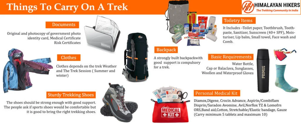
Mandatory Documents
Original and photocopy of government photo identity card- (Aadhar Card, Driving License, Voters ID, etc,)
Passport and Visa important to foreigners
Medical Certificate (First part should be filled by the Doctor and Second part by the Trekker)
Declaration Certificates
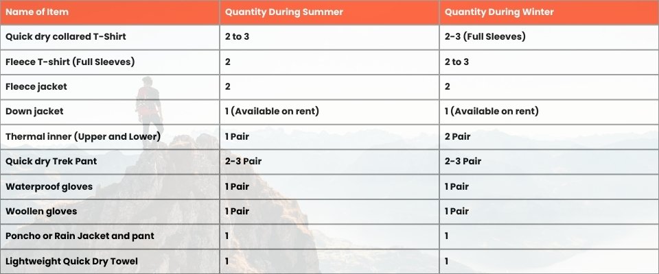
Note: – Many trekkers commit the same mistake of carrying unnecessary items on a trek which only makes the backpack heavy. It is important to know the right items to carry. It differs from season to season if you are trekking in summers then carry less layers of warm clothing and if you are trekking in winters carry enough layers to protect yourself against chilly cold.
Necessary Items for trekkers
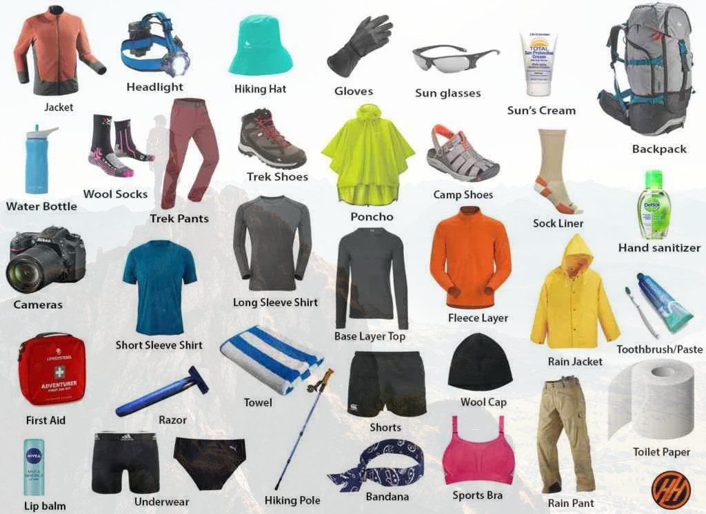
Basic Trekking Gears

The Clothes You Should Bring On Satopanth Expedition
Head Gears

Foot Gears

Personal Care Essentials

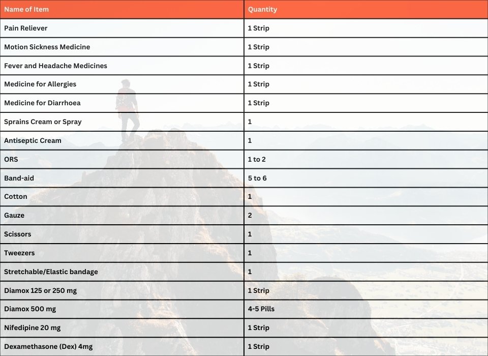
Carry a Personal Medical Kit
Are you Looking for Trekking Equipment on Rent?
If any trekker requires trekking equipment on rent, Himalayan Hikers offers the best-quality gear available for rental. Many individuals are in need of such equipment, and renting provides a cost-effective solution, allowing them to access high-quality gear at an affordable price without the need for a significant investment for short-term use.

Trek Equipment You can book directly on first day at the Base Camp.
Note:-
Please take all medicines only when prescribed by the doctor. In case you face any problem during your trek,
discuss and take advice from the Professional guide.
The Trek is one of the most popular treks in Uttarakhand, Himachal,Kashmir,Laddakh,Sikkim,Nepal, requiring both physical preparation and mental readiness. Although it is categorized as a moderate trek, reaches an elevation of over 12,720 feet and traverses remote Himalayan terrain, which can be physically and mentally challenging. Here's how you can prepare yourself for a safe and successful accomplishment of the Trek:
Physical Fitness
Building a good fitness base is essential for every trekker. The Trek itinerary involves 5 to 6 hours of walking every day. Though the trails are well-marked, they are often bumpy and include steep uphill sections, which may affect your stamina. You can overcome your physical limitation with a 6-week training program that you can begin about 2 months before your Trek. Your 6-week fitness routine should include

Pro Tip: If you have time, you can skip the Sunday training and go for a long-distance walk or mini day-hike (7–10 km) with a loaded backpack to simulate real trekking conditions. A short 1-day hike around your city/town can help a lot.
Mental Preparation
Physical strength is only half the journey, the other half is mental resilience. The trail takes you through remote clearings, steep climbs, cold starry nights, and no mobile connectivity. Be prepared to:
(I) -
Detach from the digital world.
(II) -
Embrace basic mountain living (camping, toilet tents, limited electricity).
(III) -
Push through moments of fatigue, weather discomfort, or altitude effects.
Himalayan Hikers is a reputable trekking company that places a high priority on safety. Here are some of the safety measures they take to ensure the safety of their clients during the Trek:
Experienced Guides: Himalayan Hikers hires experienced and certified guides who are well-versed in the terrain, weather conditions, and local culture. These guides have first-hand knowledge of the routes and are equipped to handle any emergency situations that may arise.
Proper Gear: The company provides all the necessary gear and equipment to their clients to ensure comfort and safety during the trek.
Hygiene and Sanitation: Himalayan Hikers places great emphasis on hygiene and sanitation during the Trek. They provide clean drinking water, hand sanitizers, and toilet tents to ensure that their clients are healthy and comfortable.
Emergency Services: The company has a well-defined protocol for handling emergency situations. They have a team of trained medical professionals who are available 24/7 and can be quickly mobilized in case of an emergency.
Acclimatization: Himalayan Hikers follows a gradual acclimatization process during treks to ensure that their clients adjust to the high altitude gradually. They also monitor the health of their clients regularly and provide necessary medical attention if required.
Overall, Himalayan Hikers places a great emphasis on safety and takes all necessary measures to ensure the safety and well-being of their clients during treks.
Trek Inclusions
| Category | Details |
|---|---|
| Transport | Dehradun to Dehradun round-trip via Tempo Traveller (Pickup & Drop) Rishikesh to Rishikesh round-trip via Tempo traveller (Pickup & drop |
| Permits & Entry | Forest Permit and Entrance Fees |
| Accommodation | Hotel in Joshimath Tented Accommodation on Twin/Triple Sharing |
| Meals | Breakfast, Lunch, Tea, Coffee, Snacks, Soup, Dinner (All meals included) |
| Camping Gear | High-Quality Dome Tents, Sleeping Bags, Mattress, Liner |
| Sanitation Setup | Separate Toilet Tents (Ladies & Gents), Dining Tent, Dining Table, Camping Chair |
| Support Staff | Kitchen Team, Trek Helpers |
| Communication Tools | Radio Walkie-Talkie |
| Trek Guides | Experienced Trek Leader & Technical Guide |
| Safety Equipment | Medical Kit, Oxygen Cylinders, Pulse Oximeter |
| Trekking Equipment | Crampons, Gaiters |
Trek Exclusions
Personal Expenses
- Personal insurance
- Personal toiletry items
- Personal medicine kit
Meals Not Included
- Day 1: Breakfast & lunch en route to base camp
- Day 6: Lunch & dinner during return journey
Mandatory Documents
- Medical fitness certificate (to be submitted before trek)
- Original government ID card or valid VISA (mandatory for forest permit entry)
Optional Services
- Offloading charge: ₹400 per bag per day
(To be paid directly at Joshimath if you choose not to carry your backpack)
Foreign Nationals
- Additional ₹1600 for trekking permit
- Passport and valid Visa are mandatory
Important Note
Himalayan Hikers offers both online and offline booking options for their treks. Here’s a breakdown of both options:
1. Online Booking:
- Website: Himalayan Hikers has an official website where trekkers can browse through different treks, check details (itineraries, costs, difficulty level, etc.), and make bookings. Payment gateways are integrated for secure online transactions.
- Third-Party Platforms: They might also be listed on various trekking or adventure booking platforms, where you can compare prices, read reviews, and make bookings.
- Email Communication: Trekkers can inquire about treks via email and complete the booking process online, following email communication and payment.
2. Offline Booking:
- Direct Office Visit: Himalayan Hikers has physical offices (especially in Uttarakhand), where trekkers can visit in person, discuss treks, and complete bookings directly.
- Phone Booking: You can also call their office to make a booking. Details about payment methods, trek dates, and other logistics can be confirmed over the phone.
Yes, Himalayan Hikers requires a 25% advance payment for booking treks, Via- Google pay or UPI, Directly Himalayan Hikers Account with the remaining amount to be paid in cash at their branch office in Sankri before the trek starts. This payment structure is typical for ensuring that bookings are confirmed while allowing trekkers flexibility in completing the payment when they arrive.
The Pangarchulla Peak Trek is an exhilarating trek in the Garhwal Himalayas, Uttarakhand, India. It offers trekkers the chance to summit the 15,069 feet (4,580 meters) high Pangarchulla Peak, providing panoramic views of the surrounding peaks and valleys.
Pangarchulla Peak is located in the Chamoli district of Uttarakhand, within the Nanda Devi Sanctuary. The trek usually starts from the village of Joshimath.
The trek starts from Joshimath. Here’s how you can reach Joshimath:
By Air: The nearest airport is Jolly Grant Airport in Dehradun, about 268 km from Joshimath. From there, you can hire a taxi or take a bus to Joshimath.
By Train: The nearest railway station is Dehradun Railway Station, about 292 km from Joshimath. You can take a bus or taxi from Dehradun to Joshimath.
By Road: Joshimath is well-connected by road. You can take a bus or taxi from Dehradun, Rishikesh, or Dehradun, which is approximately a 10-12 hour drive.


