


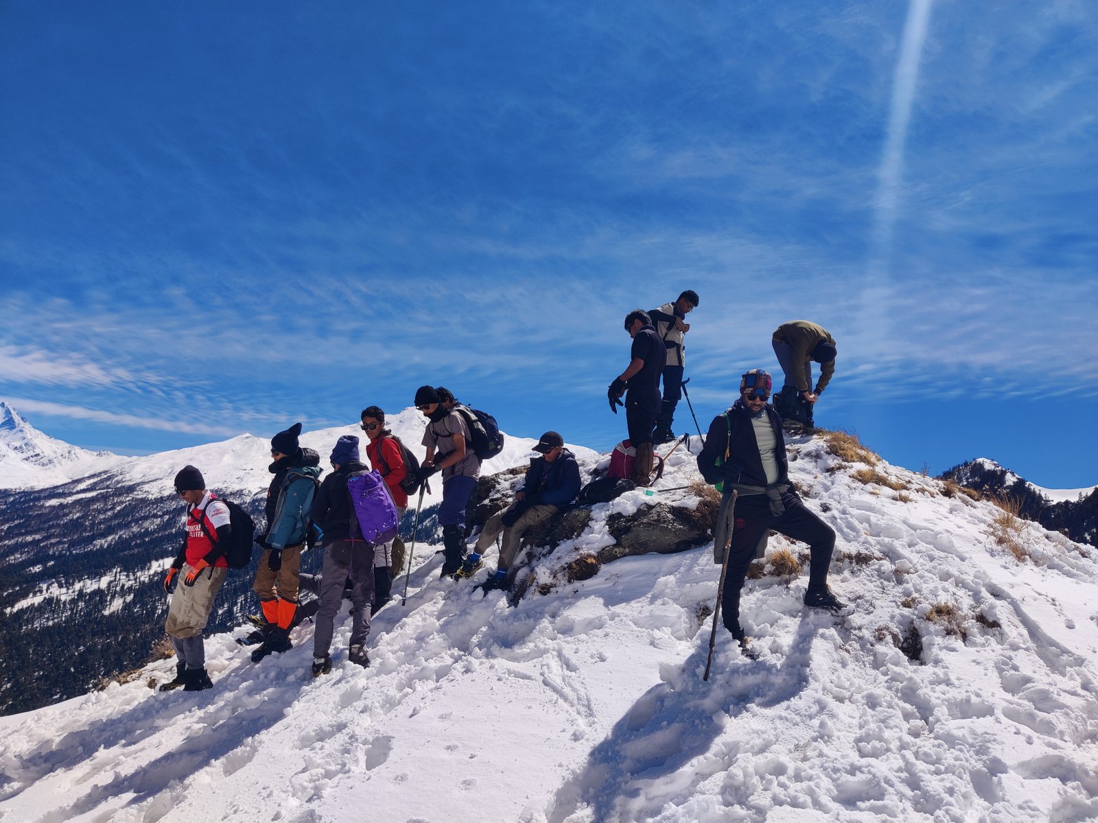
The trek begins and ends in Tugsi village, a few kilometers from the base camp, Joshimath Bazaar. The Kunari Pass and Pangarchulla Peak are spectacular in summer and thrilling in winter. it is a great destination for adventure enthusiasts in the Himalayas.
The Kuari Pass with Pangarchulla Peak trek combination is one of the most rewarding Himalayan treks for trekkers who want grand mountain views and the thrill of a high-altitude summit. Located in the Garhwal region of Uttarakhand, this trail blends dense forests, vast meadows, snowfields, and a dramatic summit ridge — all within one journey.
Why This Trek is Special both treks together?
The combined route offers some of the best Himalayan panoramas in India, including iconic peaks like
Maa Nanda Devi, Dronagiri, Hathi–Ghoda, Neelkanth, Kamet and Chaukhamba
Kuari Pass gives you the classic “Lord Curzon Trail” experience, while Pangarchulla Peak adds the thrill of climbing to 4,590 meters, making it ideal for trekkers wanting their first real summit-style challenge.
REGION & LOCATION DETAILS
State: Uttarakhand
Mountain Range: Garhwal Himalayas
Nearest Town: Joshimath Market
Start/End Points: Tugasi Village or Karchi Village
Nearest Railway: Dehradun / Rishikesh/Haridwar
Nearest Airport: Dehradun (Jolly Grant Airport)
Both the Kuari Pass and Pangarchulla Peak sit on the ridges between the Nanda Devi National Park and the Greater Himalayan ranges.
Key Point About Kuari Pass Pangarchulla Peak Trek
Before heading towards the itinerary, it is really essential to perceive the reason behind choosing the Kuari Pass & Pangarchulla peak trek.
Kuari pass & Pangarchulla peak Trek is a high-altitude mountain trek Altitudes are 15096 fit
Need proper gear & clothing for sub-zero temperatures?
Finally, you got to see so many heavenly bodies in one place like the panoramic view of the Himalayan ranges, meadows, one of the beautiful the combined route offers some of the best Himalayan panoramas in India, including iconic peaks like:
Maa Nanda Devi, Dronagiri, Hathi–Ghoda, Neelkanth, Kamet and Chaukhamba and different varieties of flora and fauna surpassing through bona fide Garhwali heritage and culture.
In your spare time Interact with locals, and you will get to know about some of the ancient tales of Indian mythology.
Beautiful landscapes so carry proper photo gear and extra battery backup.
The backpack should not exceed 10 to 12 kg only
Winter-Specific Challenges
Temperatures Going to Dec to April
Khullara can drop to –8°C to –12°C
Pangarchulla summit morning: –15°C to –20°C wind chill
Bring proper warm clothes, good Hiking shoes worm jacket, and all the equipment that will be used on the trek, and do get information about it from our team.
Terrain: Hard snow → micro spikes & gaiters needed
Ice patches → trekking poles essential
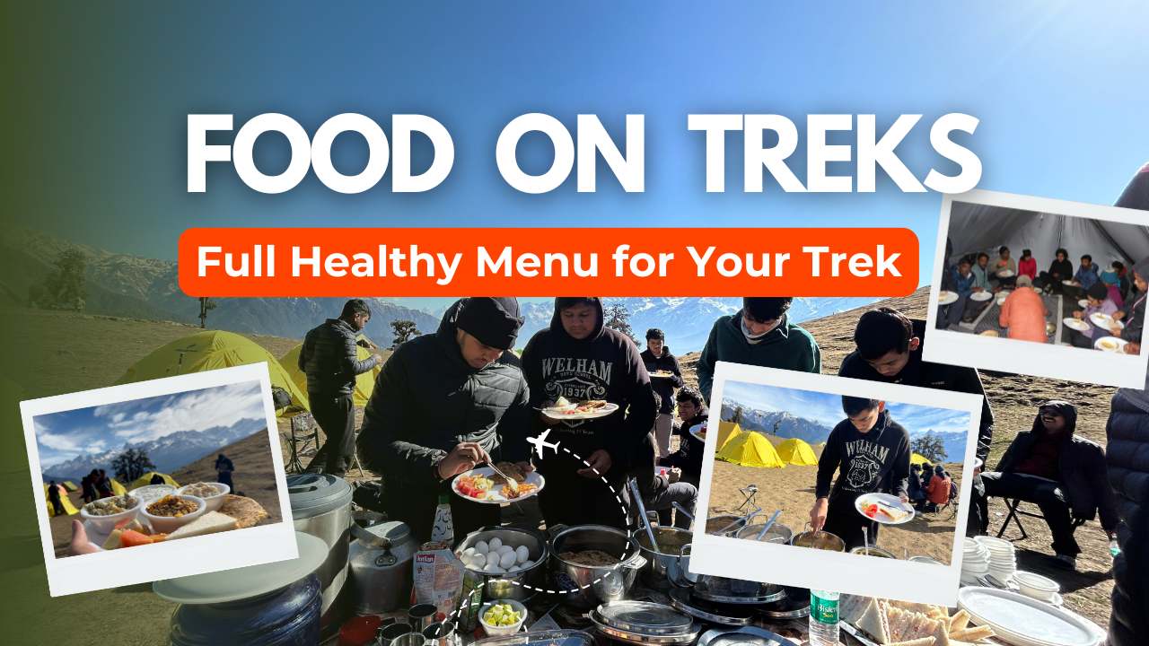
Food: We serve 05 Times meals a day including snacks and soup. A variety of delectable and healthy food is provided which includes; Indian, Chinese and other Western meals. They are nutritious and keep you fit and healthy on the trek. (Veg food or Jain Food with fruits)
Kuari Pass with Pangarchulla Peak Trek Complete Guide
Our mission has always been to ensure that no trekker steps into the Himalayas without the right perspective. A trek is not just a checklist of summits; it is a serious commitment to the outdoors. Having the right information is what separates a reckless climb from a soulful journey.
This section serves as your definitive manual for the Kuari Pass with Pangarchulla Peak Trek. We have distilled years of mountain experience and real-time feedback into this guide to give you a clear, honest picture of the trail.
We provide this depth of information because we want you to be more than just a visitor—we want you to be a prepared, responsible trekker who respects the mountains as much as we do.
Day 1 – Pickup from Dehradun Via Rishikesh → Joshimath Market 280 km /10 Hours Drive Altitude 7545 ft
Travel & acclimatization. Overnight stay Hotel at Joshimath
Day 2 – Joshimath → Dhak/Karchi → Gulling (2,800 m) 9,264 ft
Drive from Joshimath to Tugasi (15 km), then begin your 4-to-5-hour trek to Gulling camp. The trail offers scenic views of valleys, forests, and snow-capped peaks. rhododendron forest. Enjoy the stunning Himalayan panorama at Gulling and camp overnight amidst tranquil surroundings.
Day 3 – Trek from Gulling → Khullara (3,300 m) 11,014 ft
2–3 hrs gradual climb, camp at the base of Hathi–Ghoda peaks.
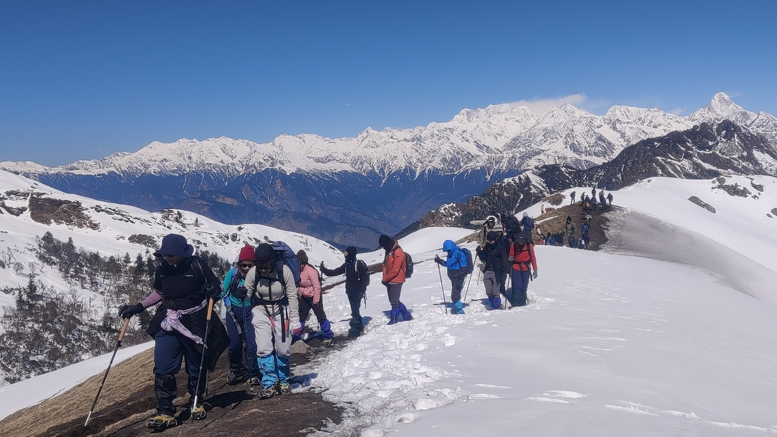
Day 4 – Khullara → Kuari Pass (3,900 m) (12,516 ft) → Return to Khullara
6–7 hrs. Grand views of Nanda Devi, Dronagiri, Hathi Ghoda, Chaukhamba.
Day 5 – Summit Day – Khullara → Pangarchulla Peak (4,590 m) 15,096 feet→ Return
- Start at 3–4 AM early morning with team Himalayan hikers
- 12–14 hrs long day
- Return to Khullara camp
Day 6: Trek from Khullara to Tugasi Village Road head and Same day Drive to Joshimath
Altitude Loss: 11,014 ft to 8,530 ft to 7,545 ft | Trek Distance: 8.5 km | Trek Duration: 6 to 7 hours | Drive Distance: 15 km | Drive Duration: 30 minutes to 1 hour
Day 7: Depart from Joshimath to Dehradun via Rishikesh
Altitude Loss: 8,530 ft to 2,089 ft | Drive Distance: 280 km | Drive Duration: 9 to 10 hours | Drop-off point for Himalayan Hikers trekkers: Prince Chowk, nearby Dehradun Railway Station
Route: Joshimath → Nandaprayag → Karnaprayag → Rudraprayag → Srinagar (Garhwal) → Devprayag → Rishikesh → Dehradun
Day 1
Day 2
Day 3
Day 4
Day 5
Day 6
Day 7
Day 1: Drive from Dehradun via Rishikesh to Joshimath Market Base Camp
Altitude Gain: 2,089 ft to 7,545 ft | Drive Distance: 280 km | Drive Duration: 9 to 10 hours | Overnight Stay: Joshimath Hotel Dhaneesh (Twin Sharing) | Pick-up point for Himalayan Hikers trekkers: Prince Chowk, nearby Dehradun Railway Station
Route: Dehradun → Rishikesh → Devprayag → Srinagar (Garhwal) → Rudraprayag → Karnaprayag → Nandaprayag → Joshimath
Himalayan Hikers organizes transport for trekkers from Dehradun or Rishikesh in the morning which will leave for Joshimath around 6:00 am to 7:00 am. Today start your journey with team Himalayan Hikers from Dehradun or Rishikesh. The Drive from Dehradun Via Rishikesh to Joshimath, which serves as the base camp for the Kuari Pass trek, offers several scenic viewpoints along the way.
Devprayag: Devprayag is the confluence of the Alaknanda and Bhagirathi rivers, where they merge to form the holy river Ganges. It is a significant pilgrimage site and offers a picturesque view of the river’s meeting point.
Rudraprayag: Rudraprayag is another confluence point on the route, where the Alaknanda and Mandakini rivers merge. The town is surrounded by the scenic beauty of the Himalayas and is considered sacred by Hindus. Evening reached at Joshimath 6 Pm Hotel Dhanesh
Day 2: Drive from Joshimath to Tugasi Village by Taxi, same day Trek to Gulling Campsite
Altitude Gain: 7,545 ft to 8,530 ft to 9,264 ft | Trek Distance: 3 kms | Trek Duration: 3 to 4 hours | Trek Difficulty: Easy to Moderate | Overnight Stay: Gulling Campsite (Twin Sharing)
Travel from Joshimath to Tugasi by taxi, which is a distance of approximately 15 kilometers. Once you reach Tugasi, you can start your trek to the Gulling camp viewpoint on the same day.
Trek from Tugasi to Gulling: Once you reach Tugasi, you can begin your trek towards the Gulling camp viewpoint. The trail from Tugasi to Gulling is approximately 03 km and can take around 3/4 hours, depending on your pace.
Enjoy the Viewpoint: As you trek from Tugasi to Gulling, you will be treated to beautiful views of the surrounding mountains, forests, and valleys. The Gulling camp viewpoint offers a panoramic vista of the Himalayan landscape. overnight at Gulling Camp.
Day 3: Trek from Gulling Camp to Khullara Campsite
Altitude Gain: 9,264 ft to 11,014 ft | Trek Distance: 5.5 km | Trek Duration: 8 to 9 hours | Trek Difficulty: Easy to Moderate
The trek begins with a steady ascent through a thick forest of Oak, Rhododendron (Buransh), and Horse Chestnut.If you are trekking in late winter/early spring, the trail is often carpeted with crimson Rhododendron flowers.In winter, this section stays snow-covered longer because the canopy blocks the sunlight.
First Glimpses of the Giants
As the treeline begins to thin, the "Big Guns" of the Garhwal Himalayas start peering over the ridges. You will get clear views of: Dronagiri (7,066 m): A massive, pyramid-shaped peak that dominates the skyline. Hathi Ghoda Parvat: Named for its resemblance to an Elephant and a Horse.
Transition to the Alpine Meadows
About halfway through, you break out of the forest. The landscape changes instantly from dark greens to the golden-brown or lush green (depending on the season) of the Alpine Bugyals. This is where the air feels thinner and the views become 360-degree panoramic.
Khullara Campsite: The Highlight
Khullara is not just a pitstop, it’s one of the most scenic campsites in the Himalayas.
The View: From your tent, you can see the Dronagiri massif, Changabang, and Kalanka.
The Vibe: It is a wide, sloping meadow. In the evening, the sunset turns the snow-capped peaks into "Golden Peaks"—a photographer's dream.
Strategic Spot: Khullara acts as the base for your final push toward Kuari Pass or the climb to Tali Top.
Day 4: Trek from Khullara to Kuari Pass Summit and descend back to Khullara Campsite
Altitude Gain & Loss: 11,014 ft to 12,516 ft to 11,014 ft | Trek Distance: 8 km | Trek Duration: 8 to 9 hours | Trek Difficulty: Moderate
The trek from the Khullara campsite to the Kuari Pass Summit and back to the Khullara viewpoint is a significant part of the Kuari Pass Trek. Khullara Camp to Kuari Pass Summit point. Start early in the morning from the Khullara campsite, which is located near Basecamp of Kuari Pass. Begin the ascent towards the Kuari Pass summit, situated at an altitude of 4,264 meters (13,993 feet).
The trail involves a steep and gradual climb, crossing through alpine meadows, rocky terrain, and possibly some snow patches, depending on the season. As you gain altitude, the panoramic views of snow-capped peaks and the surrounding Himalayan range become increasingly spectacular. Reach the Kuari Pass summit, which offers breathtaking vistas of peaks such as Nanda Devi, Kamet, Dronagiri, and Chaukhamba.
Spend some time at the summit, taking in the awe-inspiring views and capturing memorable photographs. Back to Khullara base Camp Overnight Stay: Khullara Campsite (Twin Sharing)
Day 5: Trek from Khullara to Pangarchulla Peak Summit and descend back to Khullara Campsite
Altitude Gain & Loss: 11,014 ft to 15096 ft to 11,014 ft | Trek Distance: 13 km | Trek Duration: 10 to 12 hours | Trek Difficulty: Moderate
The Trek from Khullara Camp to Pangarchulla Peak summit is a challenging yet rewarding adventure, offering stunning views of the surrounding Himalayan peaks. Distance and Elevation: The distance from Khullara Camp to Pangarchulla Peak summit is approximately 6 km one way, with an elevation gain of around 700-800 meters. Pangarchulla Peak stands at an altitude of 15,096 feet (about 4600 meters) above sea level.
Level of Difficulty: The trek from Khullara Camp to Pangarchulla Peak summit is considered to be challenging due to its steep ascent and high altitude. The terrain involves rocky trails, scree slopes, and possibly some snow patches, particularly in the early season. Trekkers should be physically fit, acclimatized to high altitude, and have prior trekking experience.
The route from Khullara Camp to Pangarchulla Peak summit starts with a gradual ascent from the campsite, following a well-defined trail through alpine meadows and rocky terrain. As you gain elevation, the trail becomes steeper and more challenging, with sections of scree slopes and loose rocks. Trekking poles may be helpful for stability, especially during the ascent.
The final stretch to the summit involves a steep climb, possibly with some scrambling over rocks. The trail may narrow and become more exposed as you approach the peak. The route is marked by cairns or trail markers, but it’s important to proceed with caution and follow the guidance of your guide or trek leader, especially in areas with difficult terrain. Take group photo then back to Base Camp Khullara Overnight Stay: Khullara Campsite (Twin Sharing)
Day 6: Trek from Khullara to Tugasi Village Road head and Same day Drive to Joshimath hotel
Altitude Loss: 11,014 ft to 8,530 ft to 7,545 ft | Trek Distance: 8.5 km | Trek Duration: 6 to 7 hours | Drive Distance: 15 km | Drive Duration: 30 minutes to 1 hour
The trek from Khullara camp to Tugasi Village and the subsequent drive back to Joshimath can be done on the same day. After breakfast trek start from the Khullara campsite. Descend from Khullara towards Tugasi Village, following the trail downhill. The trek from Khullara to Tugasi Village is approximately 8.5 kilometers and can take around 6-7 hours, depending on your pace and the trail conditions.
Drive from Tugasi Village to Joshimath:
Once you reach Tugasi Village,Himalayan Hikers arrange transport from Tugasi Villarage to Joshimath. The drive from Tugasi Village to Joshimath is approximately 15 km and takes about 30-45 minutes, overnight stay Hotel
Day 7: Depart from Joshimath to Dehradun via Rishikesh
Drive Distance: 280 km | Drive Duration: 9 to 10 hours | Drop-off point for Himalayan Hikers trekkers: Prince Chowk, nearby Dehradun Railway Station
Route: Joshimath → Nandaprayag → Karnaprayag → Rudraprayag → Srinagar (Garhwal) → Devprayag → Rishikesh → Dehradun
Today’s last breakfast with Himalayan Hikers After breakfast leave early 6 am, have your lunch en route and you can reach Dehradun evening between 6 to 7 pm,The return journey from Joshimath to Rishikesh typically involves a scenic drive through the mountains, offering beautiful views of the valleys, rivers, and Himalayan landscapes. The distance from Joshimath to Rishikesh is approximately 280 kilometers, and the drive takes around 9-10 hours, depending on the road and traffic conditions.
During the drive, you may pass through picturesque towns and villages, such as Chamoli and Devprayag, where you can witness the confluence of rivers and visit temples or other attractions. The road winds through the mountains, offering glimpses of the stunning natural beauty of the region. It’s always advisable to start early in the morning to allow ample time for the drive and to avoid traffic congestion. Along the way, you can take breaks at roadside
How Difficult is Kuari Pass with Pangarchulla Trek?
Pangarchulla Trek is not very difficult and not easy either, this trek comes in a moderate and difficult level, I myself have done this trek sometimes with, people who are trekking for the first time, we have done the entire trek, they used to need help somewhere, which we and our team used to help.
This trek is a bit difficult, but if your fitness is good and you have it in your mind that I want to trek then you can do it absolutely. Where help is needed, our guides will support you, you just have to be strong and capable of the trek. One thing is that all you can do is to have courage and I myself am passionate.
Is Pangarchulla safe for me?
Kuari Pass with Pangarchulla Trek is a safe trek if you are going with a good trekking team which you must know before booking yourself, It is important for you to know whether the bow trekking organization with which we are going is right or not, And if possible, trek with a local trekking organization, you can do the same help all the time. then your trek can be very good and memorable
The minimum age required to trek the Kuari Pass with Pangarchulla peak trek is 15 years and the maximum 55 years. The rest depends on your fitness.
About the Base camp of Kuari Pass with Pangarchulla Peak at Joshimath
It is a picturesque town in Chamoli at an altitude of 1875 m nestled amid high Himalayan peaks. It is the base camp of 10 above Himalayan treks and the gateway to famous pilgrim sites like Badrinath Dham and Hemkund Sahib.
There is spirituality in the air because of the presence of ancient temples. It is home to one of the four “Math” “Atharva Veda” by Adi Shankar Acharya. Joshimath has a tranquil charm away from the cacophony of cities.
The gushing rivers and silent streams with the cover of verdant green and the pious ancient temples in the area will surely lure you to come here again and again. Beautiful market
Macrocosmic Views in the Himalayas in Kuari Pass with Pangarchulla Peak
The unbelievable views from Pangarchulla are the reason of its demand among avid trekkers. It is a part of Nada Devi Sanctuary so it offers excellent sight of Nanda Devi, Hathi Parbat, Ghori Parbat, Barmal, haukhamba Peaks with many other snow-capped tall standing peaks.
You will witness changing sceneries on the Pangarchulla peak trek, the highly rich Flora and Fauna end after the starting of the snowline. In the starting, there are abundant Oaks, Pines, Rhododendrons, and Silver birch trees and further are snowfields and high ridges mountains.
The Pangarchulla Peak Trek is a beautiful and challenging trek that has several special parts that make it unique.
Here are some of the special parts of the Pangarchulla Peak trek:
- Khullara and Tali campsites: The trek has two beautiful campsites, Khullara and Tali, that are situated amidst the beautiful meadows, with stunning views of the surrounding peaks.
- Kuari Pass: The trek to Pangarchulla Peak includes a visit to the Kuari Pass, which offers breathtaking views of some of the highest peaks in the world, including Nanda Devi, Kamet, and Dronagiri.
- Summit climb: The climb to the summit of Pangarchulla Peak is a challenging and rewarding experience. The summit offers stunning views of the surrounding peaks and valleys and is a highlight of the trek.
- Cultural experience: The trek takes you through several remote villages where you can experience the local culture and interact with the friendly villagers. You can learn about their way of life, customs, and traditions, which makes the trek a unique and enriching experience.
- Flora and fauna: The trek takes you through dense forests of oak, rhododendron, and deodar trees, which are home to a variety of wildlife, including the Himalayan black bear, musk deer, and snow leopard. You can also spot several bird species along the way.
Overall, the Pangarchulla Peak trek is a unique and special trek that offers stunning views, a challenging climb, a cultural experience, and a chance to see some of the Himalayas’ beautiful flora and fauna.
The Best time to visit Kuari Pass with Pangarchulla Peak
Trek with Himalayan Hikers) is typically during the pre-monsoon (spring) and post-monsoon (autumn) seasons, when the weather is most stable and the views are at their best.
Himalayan Hikers take Groups for Kuari Pass with Panagrchulla peak all Months
Likes: September, October, Novembers, December, Jan, Feb, March April
If you are joining Winter season at Pangarchulla peak (roughly December → February) brings heavy snow, cold temperatures (nighttime well below freezing), and sometimes trail blockage due to snow or ice. But Himalayan Hikers take group if weathers is good so not a more difficult to attempt Pangarchulla peak summit
Early spring (March → April) is seen by many as a “golden window” because:
- The snow that accumulated during winter has compacted/settled — forming more stable surfaces (“hard ice” in some places) which can give better grip.
- After winter, before the snow fully melts, large boulder sections (dangerous, unstable terrain) are still partially buried or less exposed, making the trail safer compared to when boulder zones are fully exposed.
- In spring, there is also better visibility (fewer clouds/fog or monsoon moisture) and more daylight.
Why Himalayan Hikers recommend December‑April?
Putting it together, the reasons Himalayan Hikers (or similar trekking orgs) might recommend December‑April are:
Snow appeal — for many trekkers, the idea of lots of snow, winter landscapes, snow‑covered ridges is very attractive. The "snow magic" is strongest in winter and late winter / early spring.
Less crowding — winter months have fewer trekkers, so you might get more solitude, less "trail traffic."
Harder snow base by early spring — by March/April, snow has compressed and settled, making surfaces safer than loose snow or exposed boulders.
More stable weather windows — while winter is harsh, early spring often brings clearer skies than the monsoon or the heavy snow months.
Summit success tends to be highest in spring (March and April) when conditions (snow, visibility, trail stability) align.
Quick Pangarchulla peak Summary:
|
Season |
Snow |
Views |
Trail Condition |
Recommended |
|
April–May |
Moderate |
Excellent |
Snowy/Mixed |
Yes |
|
October–Nov |
None or minimal |
Crystal Clear |
Dry & Safe |
Yes |
|
Monsoon (Jun–Sep) |
Rainy |
Poor |
Slippery |
No |
|
Winter (Dec–Mar) |
Heavy Snow |
Often Cloudy |
Moderate Difficult |
Yes |
If you’re going with Himalayan Hikers, check their scheduled batch dates—they usually plan treks during the optimal seasons only.
1. Getting to Dehradun
Dehradun is the gateway for several popular treks in the Garhwal region of Uttarakhand, Himalayas Trekking Base Camp and Started Point Himalayas, including the Kuari Pass with Pangarchulla peak Trek. There are various ways to reach Dehradun, depending on your starting point:
By Air:
- Nearest Airport: The Jolly Grant Airport (DEHRADUN) in Dehradun is the closest airport, around 25 kms from the city center.
- Flight Options:
- Direct flights to Dehradun are available from major cities like Delhi, Mumbai, and Bangalore.
- You can also fly to Delhi (Indira Gandhi International Airport) and take a flight or travel by road/train from there to Dehradun.
By Train:
- Nearest Railway Station: Dehradun Railway Station.
- Train Services: Dehradun is well-connected to major cities like Delhi, Haridwar, and Lucknow. Some popular trains include:
- Shatabdi Express from New Delhi to Dehradun (around 5-6 hours).
- Nanda Devi Express from New Delhi to Dehradun (approximately 6-7 hours).
- You can also check other overnight trains like Doon Express and Mussoorie Express for convenience.
By Bus:
- Dehradun has a good bus network from cities like Delhi, Haridwar, Rishikesh, and other major destinations in Uttarakhand and North India.
- From Delhi to Uttarakhand Transport Corporation (UTC) buses are frequent and take around 6-7 hours to reach Dehradun.
- You can also opt for Volvo buses or private buses if you prefer comfort.
By Road:
- If you are driving, Dehradun is well-connected by road.
- From Delhi: Take NH44, which is approximately a 6-7 hour drive (approximately 270 km).
- From Haridwar: Take NH58, which will take about 1-2 hours (55 km).
- From Rishikesh: It’s about a 1-1.5 hour drive (35 km).
Himalayan Hikers has arranged transport for you from Dehradun Railway Station to Joshimath via Rishikeshat 6 AM, here’s a detailed guide on what you can expect during this journey:
1. Pickup from Dehradun Railway Station (6:00 AM)
- Be on Time: Ensure you’re at the Dehradun Railway Station at least 15-20 minutes before the scheduled time. The vehicle could be a tempo traveler, jeep, or bus, depending on the group size. The Himalayan Hikers team will likely have a representative or the driver waiting at the station.
- Tip: Look out for a vehicle or staff with a signboard from Himalayan Hikersor your trek leader’s contact number in case you need to reach out.
- Pack Light for the Ride: Keep your trek essentials (water, snacks, camera, jacket) in a small bag that you can easily access. Larger bags with trekking gear will usually be stored in the vehicle's luggage compartment.
2. Route Overview: Dehradun to Joshimath (Approx. 8-10 hours)
The drive from Dehradun to Joshimath is approximately 280 km and takes about 8-10 hours, depending on road coScenic Highlights During the Drive
- The Ganges River: The road runs parallel to the river, so you’ll have incredible views of the Ganges, especially between Rishikesh and Devprayag.
- Himalayan Views: As you get higher, the views of the Himalayas start to open up, especially once you pass Srinagar Garhwal and are closer to Rudraprayag.
- Mountain Villages and Temples: Along the way, you'll pass through small villages with traditional homes, temples, and serene landscapes. You might spot a few local trekkers and pilgrims heading towards Badrinath or Hemkund Sahib.
- Wildlife and Nature: If you're lucky, you may spot some wildlife like monkeys, eagles, and other Himalayan birds in the Rajaji National Park area.
3. Arrival in Joshimath (Approx. 4:00 PM - 5:00 PM)
- By the time you reach Joshimath, it will likely be late afternoon or early evening.
- Himalayan Hikers may stop at a hotel or a guest house in Joshimath for the night to rest, where you’ll have the chance to acclimatize before heading to Auli or Dhak Village (if it’s not your trek starting point).
- Acclimatization is important here, especially if you’re coming from lower altitudes. The air starts to get thinner, so take it easy for the day.
4. Breaks on the Way
- Himalayan Hikers may organize refreshment breaks at designated spots, such as:
- Rishikesh for breakfast or a snack.
- Rudraprayag or Devprayag for a quick tea break.
- Small villages en route for bathroom breaks and refreshments.
5. Things to Keep in Mind for the Journey
- Road Conditions: While the road is fairly well-maintained, be prepared for narrow, winding mountain roads. It can get bumpy in places, so make sure you're comfortable.
- Snack and Hydration: Carry some light snacks like nuts, energy bars, and fruits to stay fueled, and keep a water bottle handy. Though stops will be arranged, it's good to have something on hand for the journey.
- Motion Sickness: If you're prone to motion sickness, it’s advisable to take some medication (consult your doctor beforehand).
- Photography: There will be plenty of beautiful views along the way. Have your camera or phone ready for shots, but also be careful while traveling on these winding roads.
Final Thoughts:
This journey from Dehradun to Joshimath is an adventure in itself, with breathtaking views of the Himalayas, rivers, and mountain villages. Since Himalayan Hikers has organized this transport for you, you can relax and enjoy the ride, knowing that you're in safe hands with experienced drivers and guides.
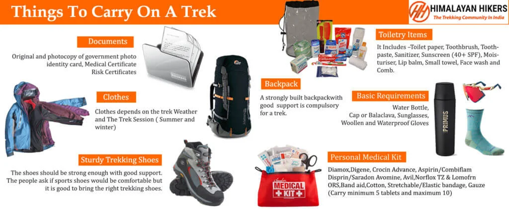
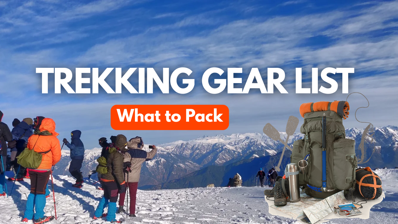
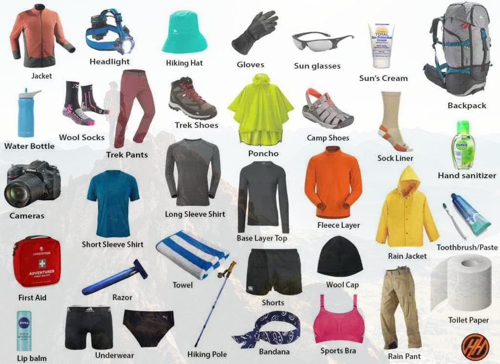
Essential Gear for the Kuari with Pangarchulla Peak Trek Packing List
1. Trekking Gear & Bags
- Main Backpack (50–60 Liters): Must have good hip support and a rain cover.
- Daypack (20 Liters): Essential if you plan to offload your main bag; carries water, snacks, and a jacket.
- Trekking Poles: Highly recommended for stability on snowy slopes.
2. Clothing (The Layering System)
- Base Layer (2-3 Pairs): Quick-dry, moisture-wicking thermals (top and bottom).
- Mid Layer (2): Fleece jackets or sweaters for insulation.
- Outer Layer (2): A high-quality padded down jacket (rated for -10°C).
- Trekking Pants (2): Water-resistant and windproof pants. Avoid jeans at all costs.
- T-shirts (3): Collared, full-sleeve dry-fit tees to prevent sunburst on the neck.
3. Footwear & Socks
- Trekking Boots: High-anchor, waterproof boots with good grip Decathlon Forclaz or similar MH 100) Asain, Jonmart hiking Shoes .
- Woolen Socks (4 Pairs): For sleeping and extra warmth at night.
- Cotton Socks (4 Pairs): For trekking during the day.
4. Headwear & Accessories
- Sun Cap: To protect against UV rays during the day.
- Woolen Cap/Balaclava: Must cover your ears to prevent heat loss.
- Neck Warmer/Buff: Protects your face from cold winds.
- Gloves: One pair of fleece liners and one pair of waterproof outer gloves.
- Sunglasses: Polarized/UV protected to prevent snow blindness.
5. Personal Hygiene & Toiletries
- Sunscreen (SPF 50+) and Lip Balm.
- Moisturizer and Sanitizer.
- Toilet paper and Biodegradable wet wipes.
- Toothbrush, Toothpaste, and a small quick-dry towel.
6. Health & First Aid
- Personal Medikit: Band-aids, crepe bandage, and antiseptic.
- Anti-Altitude Sickness: Diamox (consult your doctor first).
- Pain Relief: Volini spray or Moov.
- Water Purification: Tablets or a LifeStraw.
Quick Tips for a Successful Trek with Himalayan Hikers
- Hydration: Drink at least 3/4 liters of water daily to help with acclimatization.
- Batteries: Cold drains phone and camera batteries fast. Keep them inside your sleeping bag at night to keep them warm.
- Eco-Friendly: "Pack it in, pack it out." Don't leave any plastic on the trail.
Must-Have Medicines for Kuari with Pangarchulla Peak Trek
1. Altitude & Breathing
- Diamox (Acetazolamide): The most common medicine for AMS (Acute Mountain Sickness). It helps your body acclimatize faster.
- Note: Start a preventive dose only after consulting your doctor, as it is a diuretic.
- Camphor (Kapur): Carrying a small pouch of camphor to smell can help some people feel more comfortable while breathing in thin air.
2. Pain & Inflammation
- Combiflam / Ibuprofen: For muscle aches, joint pain, or body fever after a long day of climbing.
- Dolo 650 (Paracetamol): For mild fever or headaches (often a first sign of dehydration or AMS).
- Diclofenac Gel/Spray (Volini/Moov): Essential for calf muscle cramps or knee pain during the descent.
3. Digestive Health
- Digene / Pudin Hara: For acidity or bloating caused by heavy meals at high altitudes.
- Ondem (Ondansetron): For nausea or vomiting (common symptoms of altitude sickness).
- Eldoper / Nor-Metrogyl: For loose motions or stomach infections.
- ORS / Electral: To prevent dehydration. Mix one sachet in your water bottle every day.
4. Respiratory & Cold
- Ascoril/Alex Syrup (or Lozenges): For "Khonchi" (dry mountain cough) caused by cold, dry air.
- Cetirizine / Okacet: For allergic reactions or a runny nose.
- Avomine: If you get motion sickness during the bumpy 10-hour drive from Dehradun to Sankri.
5. First Aid Basics
- Band-aids & Cotton: For small nicks.
- Crepe Bandage: In case of a minor ankle sprain on the snowy trail.
- Betadine/Dettol: Antiseptic for any cuts.
- Anti-fungal Powder: To keep your feet dry and prevent fungal infections from wet socks.
Mandatory Document Checklist for Kuari with Pangarchulla Peak Trek
1. Government Identity Proof (Original + 2 Photocopies)
You must carry a valid, government-issued photo ID. This is required for forest check-posts Joshimath base
Accepted: Aadhar Card, Voter ID, Driver's License, or Passport.
Note: Keep two photocopies handy as one will be submitted at the Forest Office for your entry permit.
Trek Insurance mandatory
2. Medical Fitness Certificate
Himalayan Hikers prioritizes safety. You cannot start the trek without a certified medical report.
Note- The medical fitness certificate will only be accepted if issued from a local medical facility in Chamoli district. Trekkers can get it done at the basecamp in Joshimath
Requirement: The certificate must be signed and stamped by a registered medical practitioner (MBBS Doctor).
Validity: It should usually be issued within 15–30 days of the trek start date.
Criteria: It should state that your blood pressure, heart rate, and lung health are normal for high-altitude trekking.
3. Disclaimer & Waiver Form
This is a standard indemnity bond provided by Himalayan Hikers.
What it is: A document stating that you understand the risks of high-altitude trekking and are participating voluntarily.
6-Week Plan specifically tailored for Himalayan Hikers requirements.
1. Himalayan Hikers Fitness Criteria for the Kuari with Pangarchulla Peak Trek
Himalayan Hikers emphasize that a trekker should be able to cover a certain distance comfortably to ensure they don't get exhausted before the summit.
- The Benchmark: Cover 5 km in 30 to 35 minutes.
2. The 6-Week "Himalayan Hikers" Training Schedule
Weeks 1-2: Base Building (The "Startup" Phase)
- Running: 3 days a week. Run/Walk 3 km.
- Strength
- Knee Pushups: 3 sets of 15 (Total 45).
- Half Squats: 4 sets of 18 (Total 72).
- Plank: 2 sets of 30 seconds.
- Focus: Getting the heart rate up and opening the lungs.
Weeks 3-4: Endurance Loading (The "Intermediate" Phase)
- Running: 4 days a week. | Target: 5 km in 32-35 minutes.
- Strength
- Stair Climbing: Climb 3-4 floors 5 times. (Excellent for the Pangarchulla Peak Trek summit slope).
- Knee Pushups: 4 sets of 20.
- Plank: 3 sets of 40 seconds.
- Himalayan Hikers Tip: Start walking with your actual trekking shoes once a week to break them in and avoid blisters on the trek.
Weeks 5-6: Peak & Approval (The "Summit" Phase)
- Running: 4 days a week. Increase distance to 4.5 km.
- Strength
- Knee Pushups: 3 sets of 15 reps per leg.
- Half Squats: 4 sets of 20.
- Plank: 1 set of 90 seconds (or 3 sets of 30s).
- Proof: Ensure you have recorded at least 3-4 successful 5km runs on your app
3. Modified Exercise Breakdown (As per your request)
| Exercise | Target for Pangarchulla Peak Trek | Himalayan Hikers Logic |
|---|---|---|
| Jogging / Running | 5 km (35 mins) | Ensures your heart can handle low oxygen at 12,516 ft. |
| Knee Pushups | 45 Reps (3×15) | Builds shoulder strength for your 10kg rucksack. |
| Half Squats | 72 Reps (4×18) | Protects your knees during the steep descent from the summit. |
| Forward Lunges | 30 Reps total | Essential for balance on slippery “Hard Ice” patches. |
| Planks | 1 Minute total | Keeps your posture straight while climbing with a bag. |
4. "Himalayan Hikers" kye point for Kuari with Pangarchulla Peak Trek fitness
- Joshimath 01 (Base Camp): This is where your oxygen levels and fitness will first be checked.
- Micro spikes & Gaiters: Himalayan Hikers usually provide these. Your training (specifically lunges) will help you walk comfortably while wearing this extra weight on your feet.
- Hydration (The 4L Rule): Himalayan Hikers guides are very strict about water. Practice drinking 3-4 liters of water during your training weeks.
- AMS (Acute Mountain Sickness): If you are fit, your body uses oxygen better, significantly reducing your chances of headaches or nausea at the summit.
5. What to show the Himalayan Hikers Team
- Strava/Nike Profile: A screenshot or link showing you have been active for at least 4 weeks.
- Medical Certificate: Unlike just fitness apps, Himalayan Hikers requires a signed Medical Fitness Certificate by a doctor.
- Consistency: Show them that you didn't just run once, but you have been "Trek-Fit" for a month.
This is a suggestion that will help you on your trek, but if you are generally fit and healthy, you can prepare according to your own preferences.
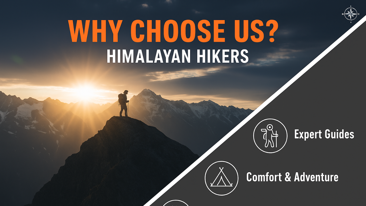
Why Himalayan Hikers is the Safest Choice for Kuari With Pangarchulla Peak Trek
At Himalayan Hikers, your safety is not just a protocol; it is our heritage. With over 35 years of experience and our roots in Joshimath we provide a level of security that only locals can offer.
1. Elite Safety Standards
- NIM Certified Leaders: Our trek leaders are certified from the Nehru Institute of Mountaineering (NIM). (IMF Indian mountaineering foundation) They are experts in high-altitude rescue and wilderness first aid.
- Daily Health Checks: We conduct twice-daily health screenings using Oximeters and BP Monitors to track your oxygen saturation and pulse.
- Emergency Oxygen & Kits: Every batch carries portable Oxygen Cylinders and a comprehensive medical kit stocked with essential high-altitude medicines.
- Technical Gear: We provide high-quality Micro-spikes (Crampons) for grip on slippery snow and Gaiters to keep snow out of your boots.
2. Premium Accommodation Tents
- High-Altitude Camping: We use Premium 4-Season Dome Tents designed to withstand heavy snowfall and bone-chilling winds.
- Insulated Bedding: To ensure a warm sleep in -10°C, we provide high-quality sleeping bags, linner, rated for extreme temperatures, along with thick foam mats for extra insulation.
3. Reliable Transport Services
Best Hotel Accommodation at Joshimath
Dehradun: We provide pickup and drop services from Dehradun to Dehradun via Rishikesh
- Safe Mountain Driving: Our drivers are locals who are experts at navigating the winding, snow-covered roads of the Himalayas.
- Vehicle Fleet: We use comfortable and well-maintained vehicles like Tempo Travelers, Ertiga Taxi, ensuring a smooth journey with Himalayan Hikers
4. Nutritious & Fresh Meals
Note: We Five three meals a day including snacks and soup. A variety of delectable and healthy food is provided which includes; Indian, Chinese and other Western meals. They are nutritious and keep you fit and healthy on the trek (veg food or Jain food & Egg) Daily fruits keep your energy levels high.
Hygiene First: Our kitchen staff follows strict hygiene standards, ensuring clean drinking water (boiled/filtered) at all campsites.
Enhanced Technical Safety Measures
| Safety Feature | Benefit to the Trekker | The Himalayan Hikers Edge |
|---|---|---|
| Gaiters & Micro-spikes | Prevents slips on the Kuari With Pangarchulla Peak Trek Summit or glacier patches. | Provided by the company to ensure all hikers have pro-grade gear. |
| Radio Communication | Essential in "No Network" zones for base camp contact. | Guides carry high-frequency Walkie-Talkies for emergency backup. |
| Mule Management | Rapid evacuation if a trekker falls ill. | A dedicated backup of mules/horses is always on standby for quick descent. |
| Eco-Trekking | Protects the fragile Himalayan ecosystem. | Strict "Leave No Trace" policy to keep the Valley of Gods pristine. |
| Category | Details |
|---|---|
| Transport | Dehradun to Dehradun round-trip via Tempo Traveler (Pickup & Drop) Rishikesh to Rishikesh round-trip via Tempo Traveler (Pickup & Drop) |
| Permits & Entry | Forest Permit and Entrance Fees |
| Accommodation | Hotel in Joshimath Tented Accommodation on Twin/Triple Sharing |
| Meals | Breakfast, Lunch, Tea, Coffee, Snacks, Soup, Dinner (All meals included) |
| Camping Gear | High-Quality Dome Tents, Sleeping Bags, Mattress, Liner |
| Sanitation Setup | Separate Toilet Tents (Ladies & Gents), Dining Tent, Dining Table, Camping Chair |
| Support Staff | Kitchen Team, Trek Helpers |
| Communication Tools | Radio Walkie-Talkie |
| Trek Guides | Experienced Trek Leader & Technical Guide |
| Safety Equipment | Medical Kit, Oxygen Cylinders, Pulse Oximeter |
| Trekking Equipment | Crampons, Gaiters |
Personal Expenses
- Personal insurance
- Personal toiletry items
- Personal medicine kit
Meals Not Included
- Day 1: Breakfast & lunch en route to base camp
- Day 7: Lunch & dinner during return journey
Mandatory Documents
- Medical fitness certificate (to be submitted before trek)
Note- The medical fitness certificate will only be accepted if issued from a local medical facility in Chamoli district. Trekkers can get it done at the basecamp in Joshimath - Original government ID card or valid VISA (mandatory for forest permit entry)
Optional Services
- The porter fee for the entire trek is ₹2,000.
(To be paid directly at Joshimath if you choose not to carry your backpack)
Foreign Nationals
- Additional ₹2000 for trekking permit
- Passport and valid Visa are mandatory
Important Note
Himalayan Hikers offers both online and offline booking options for their treks. Here’s a breakdown of both options:
1. Online Booking:
- Website: Himalayan Hikers has an official website where trekkers can browse through different treks, check details (itineraries, costs, difficulty level, etc.), and make bookings. Payment gateways are integrated for secure online transactions.
- Third-Party Platforms: They might also be listed on various trekking or adventure booking platforms, where you can compare prices, read reviews, and make bookings.
- Email Communication: Trekkers can inquire about treks via email and complete the booking process online, following email communication and payment.
2. Offline Booking:
- Direct Office Visit: Himalayan Hikers has physical offices (especially in Uttarakhand), where trekkers can visit in person, discuss treks, and complete bookings directly.
- Phone Booking: You can also call their office to make a booking. Details about payment methods, trek dates, and other logistics can be confirmed over the phone.
Yes, Himalayan Hikers requires a 25% advance payment for booking treks, Via- Google pay or UPI, Directly Himalayan Hikers Account with the remaining amount to be paid in cash at their Basecamp Joshimath before the trek starts.

This trek is located in the Garhwal Himalayas of Uttarakhand, near Joshimath. It is part of the famous Lord Curzon Trail and offers stunning views of peaks like Nanda Devi, Chaukhamba, and Dronagiri.
Kuari Pass stands at approximately 12,500 ft, while Pangarchulla Peak reaches around 15,000 ft. Pangarchulla is the highest point of the trek.
Kuari Pass is considered easy to moderate, making it suitable for beginners. However, Pangarchulla Peak is moderate to difficult due to steep climbs and snow sections.
The trek usually takes 6 to 7 days to complete, covering a distance of around 50–55 km.
The best time for this trek is from March to May and September to November. The Pangarchulla summit is typically attempted during spring.
Yes, beginners can do the Kuari Pass trek. However, attempting Pangarchulla Peak requires good fitness and preferably some prior trekking experience.
The summit day is the most challenging part as it can take 10–12 hours and involves steep ascents, snow slopes, and rocky terrain.
You should be able to run 5 km in about 30–35 minutes. Good stamina and strong leg muscles are essential for this trek.
Yes, since the trek reaches high altitudes, symptoms like headache, nausea, and fatigue may occur. Proper acclimatization is important.
Yes, forest permits and trekking permits are required. These are usually arranged by trekking agencies.
The trek offers a variety of landscapes including dense forests, alpine meadows (bugyals), snowfields, and panoramic Himalayan views.
Kuari Pass can be done in winter, but Pangarchulla Peak is generally avoided due to heavy snow and unsafe conditions.
Essential gear includes waterproof trekking shoes, warm clothing, trekking poles, and microspikes during the snow season.
The trek usually starts from Rishikesh, then proceeds to Joshimath, and finally begins from Dhak or Tugasi village.
This trek is popular because it offers a perfect mix of forests, meadows, and a summit climb, along with breathtaking 360-degree views of the Himalayas.
.jpg)
.jpg)
.jpg)
.jpg)
.jpg)


.webp)