


The approximate altitude of the Warwan Valley trek varies throughout the route, with the highest point being the Margan Pass (also known as Margan Top) at around 4,100 meters (approximately 13,451 feet) above sea level. The starting point of the trek, Gulabgarh, is situated at a lower altitude, and as you ascend along the trail, you will reach higher altitudes.
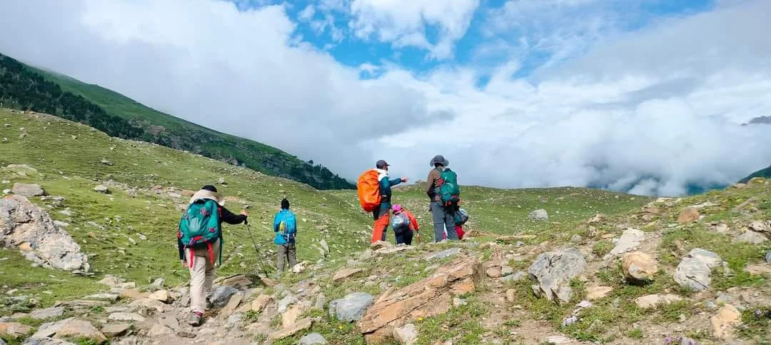
The trek offers trekkers the opportunity to explore different terrains and sceneries as they move through lush meadows, dense forests, and rocky terrains while enjoying views of snow-capped peaks and glacial streams.
Key Points About Warwan Valley Trek
Trek Difficulty: The Warwan Valley Trek is considered to be a moderately difficult to challenging trek. Trekkers need to have a good level of physical fitness and prior trekking experience to undertake this adventure.
Duration: The trek usually takes around 8 to 10 days to complete, depending on the specific itinerary chosen by the trekking group.
Starting Point: The typical starting point of the Warwan Valley trek is the village of Gulabgarh, which is accessible from the town of Kishtwar.
Terrain and Scenery: The trek offers a diverse range of landscapes, including lush green meadows, dense forests, glacial streams, and snow-capped peaks. Trekkers pass through remote villages and get a glimpse of the local culture and way of life.
Highlights: Some of the notable highlights of the trek include crossing the Margan Top at an altitude of around 4,100 meters, exploring the lush green meadows of the Inshan Valley, and camping near the pristine Tarsar and Marsar lakes.
Permits and Regulations: As the Warwan Valley is located in Jammu and Kashmir, which is a sensitive region, it is essential to obtain the necessary permits and adhere to any regulations set by the local authorities.
Weather: The best time to undertake the Warwan Valley trek is during the summer months, typically from June to September, when the weather is relatively milder and the trails are accessible.
Local Support: It is recommended to go on the trek with a reputable trekking agency that can provide experienced guides and support staff to ensure a safe and enjoyable journey.
Please note that conditions and information might have changed after my last update. Before planning any trek, it is crucial to gather the most up-to-date information about the region, weather conditions, and any necessary permits or guidelines from local authorities or trekking agencies. Additionally, given the political situation in the region, it’s essential to stay informed about the current security situation and travel advisories.
Warwan Valley Trek Complete Guide
Our mission has always been to ensure that no trekker steps into the Himalayas without the right perspective. A trek is not just a checklist of summits; it is a serious commitment to the outdoors. Having the right information is what separates a reckless climb from a soulful journey.
This section serves as your definitive manual for the Warwan Valley Trek. We have distilled years of mountain experience and real-time feedback into this guide to give you a clear, honest picture of the trail.
We provide this depth of information because we want you to be more than just a visitor—we want you to be a prepared, responsible trekker who respects the mountains as much as we do.
DAY 1: Pickup to you from Srinagar Drive to Panikhar (10,700 ft )185 km (7/8hours)
DAY 2: Trek from Panikhar to Denora Camp 12 km (7/8hours) (12375 ft) overnight stay Camp
DAY 3: Trek from Denora Camp to Kalapari Camp 03 km) (2/3hours) 12875 ft) overnight stay Camp
DAY 4: Rest day and Exploration Day
DAY 5: Trek from Kalapari to Kaintal via Lomvilad Pass (17 km) (11/12 hours) 14495 ft) overnight stay Camp
DAY 6: Trek from Kaintal to Humpet Camp (16.5km) (7/8 hours) 11120 ft) overnight stay Camp
DAY 7: Trek from Humpet to Sukhnai Camp (14 km) (7/8 hours) (9320 ft) overnight stay Camp
DAY 8: Trek from Sukhnai to Basmina and drive to Mati Gawran (16.5 km) (6/7 hours) 8350 ft) overnight stay Camp
DAY 9: Drive from Mati Gawran to Srinagar (111 km) (3/4 hours) our service end here We will reach Srinagar latest by 1 pm, Last 3:00 pm
Day 1
Day 2
Day 3
Day 4
Day 5
Day 6
Day 7
Day 8
Day 9
Day 1: Pickup to you from Srinagar Drive to Panikhar (10,700 ft )185 km (7/8 hours)
The journey from Srinagar to Panikhar is approximately 185 kilometers and can take around 7 to 8 hours, depending on the road conditions and traffic. The route usually follows the Srinagar-Leh Highway and offers breathtaking views of the picturesque landscapes of Jammu and Kashmir.
Here’s a rough breakdown of the route and key locations you may pass through:
Srinagar: The starting point of the journey is the beautiful city of Srinagar, known for its Dal Lake, Mughal gardens, and scenic surroundings.
Sonamarg: As you leave Srinagar, you’ll pass through Sonamarg, a stunning valley known for its lush meadows and the Thajiwas Glacier.
Zoji La Pass: After Sonamarg, you’ll ascend towards the famous Zoji La Pass, which is one of the crucial mountain passes on the Srinagar-Leh Highway. The pass offers panoramic views of the snow-capped peaks.
Drass: Often referred to as the “second coldest inhabited place on Earth,” Drass is a small town you’ll encounter on the way, known for its extreme cold temperatures during winters.
Kargil: Kargil is a significant town on the Srinagar-Leh Highway, known for its historical importance during the Kargil War.
Mulbekh: On the route, you’ll pass through Mulbekh, known for its ancient rock carvings and a giant statue of Maitreya Buddha.
Panikhar: Finally, you’ll reach Panikhar, which is situated at an altitude of around 10,700 feet. Panikhar offers mesmerizing views of the surrounding mountains and is a starting point for several treks, including the Nun Kun Trek.
Day 2: Trek from Panikhar to Denora Camp 12 km (7/8 hours) (12375 ft) overnight stay Camp
Distance: Approximately 12 kilometers
Duration: Around 7 to 8 hours (depending on trekking pace and conditions)
The trek from Panikhar to Denora Camp is a challenging but rewarding one, taking you through the stunning landscapes of the region. Here’s a general description of the route:
Panikhar: The trek starts from the village of Panikhar, situated at an altitude of around 10,700 feet. Enjoy the surrounding views of the mountains before you begin your trek.
Gradual Ascent: The initial part of the trek involves a gradual ascent through meadows and small villages. You’ll be surrounded by breathtaking views of the Himalayan ranges.
River Crossings: During the trek, you might encounter some glacial streams or rivers that you’ll need to cross. Depending on the water levels, these crossings can add a bit of adventure to the journey.
Denora Camp: After a challenging but exhilarating trek, you’ll reach Denora Camp, situated at an altitude of approximately 12,375 feet. Denora is a beautiful camping spot surrounded by picturesque mountain views, making it an ideal place to rest and spend the night.
It’s important to note that trekking conditions can vary depending on the weather and season. It’s advisable to go with an experienced guide or through a reputable trekking agency to ensure safety and proper navigation along the route.
Before starting the trek, make sure you are well-prepared with the necessary trekking gear, clothing, and supplies. Additionally, acclimatize yourself to the high altitude gradually to reduce the risk of altitude-related issues. Remember to carry enough water and snacks to keep yourself energized throughout the trek.
Day 3: Trek from Denora Camp to Kalapari Camp 03 km) (2/3 hours) 12875 ft) overnight stay Camp
Distance: Approximately 3 kilometers
Duration: Around 2 to 3 hours (depending on trekking pace and conditions)
Altitude: Kalapari Camp is situated at an altitude of around 12,875 feet.
The trek from Denora Camp to Kalapari Camp is relatively shorter and less strenuous compared to the previous day’s trek. Here’s a general description of the route:
Denora Camp: The trek starts from Denora Camp, where you spent the previous night. Enjoy the serene surroundings and prepare for the day’s journey.
Gradual Ascent: The trail from Denora to Kalapari involves a gradual ascent through the scenic landscapes of the Warwan Valley. You’ll pass through beautiful meadows, rocky terrain, and possibly encounter some small streams along the way.
Views: The trek offers stunning views of the surrounding mountains, making it a picturesque experience for trekkers.
Kalapari Camp: After a relatively easy hike of 2 to 3 hours, you’ll arrive at Kalapari Camp. Kalapari is another beautiful camping spot, and it is located at an altitude of approximately 12,875 feet. The campsite offers mesmerizing views of the valley and the surrounding peaks.
The trek from Denora Camp to Kalapari Camp is relatively short, providing trekkers with some time to relax and enjoy the surroundings at the campsite. It’s important to acclimatize yourself to the high altitude and keep yourself hydrated during the trek.
Rest day and Exploration Day
The Warwan Valley trek, you have a rest day, which is an excellent opportunity to take a break from the physical demands of trekking and explore the surrounding area. Rest days are crucial during treks to allow your body to acclimatize to the high altitude and to prevent exhaustion and altitude sickness.
Day 5: Trek from Kalapari to Kaintal via Lomvilad Pass (17 km) (11/12 hours) 14495 ft) overnight stay Camp
Warwan Valley trek, you will embark on a challenging trek from Kalapari to Kaintal, crossing the Lomvilad Pass. This is a long and demanding day of trekking, covering approximately 17 kilometers and taking around 11 to 12 hours, depending on the trekking pace and conditions.
Here’s a general description of the route and the views you might encounter during this part of the trek:
Kalapari Camp: The trek starts from the Kalapari Campsite, situated at an altitude of around 12,875 feet. Enjoy the beautiful sunrise and the serene surroundings before starting your trek.
Ascent to Lomvilad Pass: The trail from Kalapari will involve a challenging ascent to the Lomvilad Pass, which is situated at an altitude of approximately 14,495 feet. The path may be steep and rocky, demanding stamina and determination from trekkers.
Views from Lomvilad Pass: At the Lomvilad Pass, you will be rewarded with panoramic views of the surrounding mountains and valleys. The breathtaking vistas make the effort of the ascent worthwhile.
Descent to Kaintal: After reaching the pass, the trail descends towards Kaintal, a beautiful camping spot located at a lower altitude. The descent may also be challenging, so proper caution is advised.
Views of Kaintal: As you approach Kaintal, you’ll be treated to stunning views of the valley and the surrounding landscape. The campsite at Kaintal offers a peaceful and picturesque setting for spending the night.
Overnight Stay: Set up camp at Kaintal, situated at an altitude of around 14,495 feet, and rest after a long day of trekking.
Day 6: Trek from Kaintal to Humpet Camp (16.5km) (7/8 hours) 11120 ft) overnight stay Camp
you will continue your journey from Kaintal to Humpet Camp. This day’s trek covers approximately 16.5 kilometers and takes around 7 to 8 hours, depending on the trekking pace and trail conditions.
Here’s a general description of the route and the views you might encounter during this part of the trek:
Kaintal Camp: The day starts from the Kaintal campsite, situated at an altitude of around 14,495 feet. After breakfast, prepare for the day’s trek.
Ascent and Descent: The trail from Kaintal involves a mix of ascents and descents. You might encounter some steep sections and rocky terrain, requiring careful footing.
Views of the Valley: As you trek along the route, you’ll be treated to beautiful views of the Warwan Valley and the surrounding mountains. The landscape is picturesque, making the trek enjoyable and rewarding.
Humpet Camp: After approximately 7 to 8 hours of trekking, you’ll reach the Humpet Camp, situated at an altitude of around 11,120 feet. The campsite offers a serene and peaceful setting to rest for the night.
Please note that while this day’s trek is shorter than some of the previous days, it still requires a good level of fitness and stamina. The terrain can be challenging, so trek cautiously and take breaks as needed.
As always, trek with an experienced guide or through a reputable trekking agency for safety and proper navigation. Weather conditions can be unpredictable in mountainous regions, so it’s essential to stay informed and be prepared for any changes in the weather.
Enjoy the scenic beauty of the Warwan Valley as you progress on your trek to Humpet Camp. Take the time to appreciate the natural surroundings and immerse yourself in the tranquility of the region. Rest well at the campsite to prepare for the next day’s trekking adventure
Day 7: Trek from Humpet to Sukhnai Camp (14 km) (7/8 hours) (9320 ft) overnight stay Camp
Humpet Camp: The day starts from the Humpet campsite, situated at an altitude of around 11,120 feet. After a good night’s rest, prepare for the day’s trek.
Gradual Descent: The trail from Humpet to Sukhnai involves a gradual descent, which can be relatively easier compared to some of the previous days. The path may pass through lush meadows and forested areas, providing a refreshing change of scenery.
River Crossings: During the trek, you might come across some glacial streams or rivers that you’ll need to cross. Depending on the water levels, these crossings can add a bit of adventure to the journey.
Views of Sukhnai: As you trek along the route, you’ll be treated to glimpses of the Sukhnai region, known for its serene beauty and charming landscapes.
Sukhnai Camp: After approximately 7 to 8 hours of trekking, you’ll reach the Sukhnai Camp, situated at an altitude of around 9,320 feet. The campsite offers a picturesque setting to spend the night.
Overall, this day’s trek involves a relatively easier descent, providing an opportunity to soak in the natural beauty of the Warwan Valley. However, even though the terrain is not as steep, it still requires a good level of fitness and endurance.
Day 8: Trek from Sukhnai to Basmina and drive to Mati Gawran (16.5 km) (6/7 hours) 8350 ft) overnight stay Camp
Sukhnai Camp: The day starts from the Sukhnai campsite, situated at an altitude of around 9,320 feet. After breakfast, prepare for the day’s trek.
Gradual Descent: The trail from Sukhnai to Basmina involves a gradual descent. As you descend, you’ll pass through beautiful landscapes, which might include meadows, forests, and charming hamlets.
Village of Basmina: The trek will take you to the village of Basmina, which is situated at an altitude of approximately 8,350 feet. The village offers a glimpse of the local way of life and culture.
Drive to Mati Gawran: After reaching Basmina, you will have a drive to Mati Gawran, your destination for the day. The drive will take you through scenic landscapes, giving you a chance to relax and enjoy the views.
Overnight Camp: You will spend the night at Mati Gawran, where a campsite will be set up for the trekkers. Rest and rejuvenate after a day of trekking and driving.
Please note that even though this day’s trek involves a gradual descent, it still requires a good level of fitness and endurance. Trek cautiously and take breaks as needed.
Day 9: Drive from Mati Gawran to Srinagar (111 km) (3/4 hours) our service end here We will reach Srinagar latest by 1 pm. Last 3:00 pm
Today is the last day with team Himalayan Hikers – Mati Gawran, you will embark on a drive back to Srinagar. The distance from Mati Gawran to Srinagar is approximately 111 kilometers, and the drive usually takes around 3 to 4 hours, depending on the road conditions and traffic.
If you leave Mati Gawran early in the morning, you should be able to reach Srinagar by 1 pm at the latest, considering the average driving time. This will give you some buffer time in case of any unexpected delays during the journey.
Difficult Level in Warwan Valley Trek?
The difficulty level of the Warwan Valley trek is considered to be moderate to challenging. It is not recommended for beginners or those with little trekking experience. The trek involves several factors that contribute to its difficulty:
High Altitude: The trek takes you to high altitudes, and the highest point, Margan Pass (Margan Top), is at around 4,100 meters (approximately 13,451 feet) above sea level. At such elevations, the air becomes thinner, making breathing more difficult and increasing the risk of altitude-related issues like Acute Mountain Sickness (AMS).
Long Duration: The Warwan Valley trek typically spans around 8 to 10 days, depending on the specific itinerary chosen. The extended duration requires good physical stamina and endurance to sustain the daily trekking hours and challenges.
Remote and Isolated: The region is relatively remote and less frequented by trekkers compared to more popular trekking destinations. Facilities and amenities may be limited, and the trekking group needs to be self-sufficient for most of the journey.
Terrain: The trek involves navigating through various terrains, including steep ascents and descents, rocky paths, moraines, and uneven terrain. Trekking poles and proper footwear are essential to handle these diverse landscapes.
Weather: The weather in mountainous regions can be unpredictable, and conditions can change rapidly. Trekkers may encounter rain, snow, or harsh sunlight during the trek, which can add to the challenge.
River Crossings: The trek may involve crossing glacial streams and rivers, which can be challenging, especially during monsoon or when the water levels are high.
Physical Fitness: Trekkers need to have a good level of physical fitness to undertake the Warwan Valley trek. Regular exercise and cardiovascular training will help prepare the body for the demands of the trek.
Best Time To Visit the Warwan Valley Trek?
During the summer months typically from June to September is considered the trekking season in the region due to the following reasons:
Weather: During the summer months, the weather in Warwan Valley is relatively milder and more predictable. The temperatures are moderate, making it comfortable for trekking. The higher altitudes also become more accessible as the snow melts, allowing trekkers to navigate the trails safely.
Blooming Meadows: The valley comes alive with vibrant colors during the summer as the meadows and alpine flowers bloom. The picturesque landscapes make the trek even more rewarding and visually appealing.
Accessibility: The roads leading to the starting point of the trek in Gulabgarh are generally open and accessible during the summer months, making it easier for trekkers to reach the region.
Lakes and Streams: The glacial lakes and streams in the Warwan Valley are at their fullest during the summer, creating a serene and tranquil environment along the trekking route.
Cultural Festivals: The summer months coincide with various cultural festivals in the region, providing an opportunity for trekkers to experience the local culture and traditions.
How to Reach Srinagar for the Warwan Valley Trek?
You have several transportation options. Here are the most common ways to reach Srinagar:
By Air: Srinagar has its own domestic airport, Sheikh ul-Alam International Airport, which is well-connected to major cities in India. You can take a flight from your nearest major airport to Srinagar. From the airport, you can hire a taxi or use public transportation to reach the starting point of the trek.
By Train: The nearest major railway station to Srinagar is Jammu Tawi Railway Station, located in Jammu city. From Jammu, you can take a taxi, bus, or hire a private vehicle to reach Srinagar. The road journey from Jammu to Srinagar takes around 6 to 8 hours.
By Road: Srinagar is well-connected by road to various cities in North India. You can take a bus or hire a taxi to reach Srinagar from neighboring states like Punjab, Himachal Pradesh, and Jammu and Kashmir. Keep in mind that the availability of transport options may vary depending on your location and the time of travel. During the winter months, the Srinagar-Leh Highway is closed due to heavy snowfall, so it’s essential to plan your travel accordingly.
Before you start your journey to Srinagar, make sure to check the latest travel advisories, road conditions, and any other relevant information related to your trip. Additionally, for the Warwan Valley trek, it’s advisable to contact a reputable trekking agency or guide in advance to arrange your trekking expedition and ensure a safe and enjoyable experience in this beautiful region of Jammu and Kashmir.
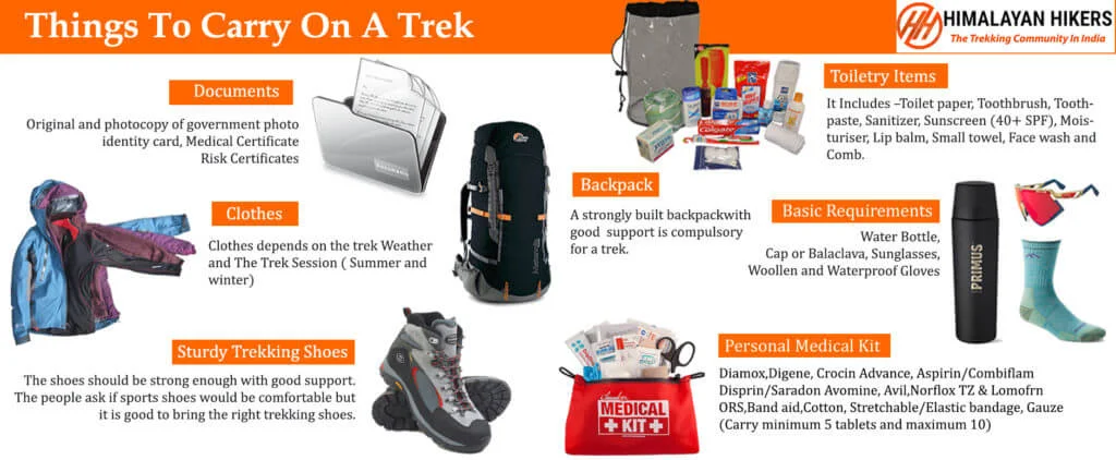
Essential Gear List for Warwan Valley Trek
The Warwan Valley Trek is one of the most scenic and remote treks in the Kashmir Himalayas. The trail passes through alpine meadows, high mountain passes, glaciers, and remote villages. Carrying the right gear is essential for safety and comfort during the trek.
1. Trekking Gear & Bags
- Main Backpack (55–65 Liters): A strong trekking backpack with good hip support and rain cover.
- Daypack (20–30 Liters): Useful for carrying water bottles, snacks, and essential items during the trek.
- Trekking Poles: Highly recommended for balance on steep ascents, glacier sections, and rocky trails.
- Rain Cover / Poncho: Essential due to unpredictable mountain weather.
- Headlamp / Torch: Useful for early morning summit climbs or late campsite arrivals.
2. Clothing (Layering System)
Base Layer (2–3 pairs)
- Quick-dry thermals (top & bottom)
- Moisture-wicking fabric
Mid Layer (2)
- Fleece jackets or warm sweaters
Outer Layer (1–2)
- Down jacket or padded jacket
- Waterproof rain jacket
Trekking Clothes
- Trekking Pants (2): Quick-dry and stretchable.
- T-shirts (3): Full sleeve dry-fit tees for sun protection.
- Note: Avoid wearing jeans during the trek.
3. Footwear & Socks
- Trekking Boots: Waterproof trekking shoes with strong grip.
- Woolen Socks (3–4 pairs): For warmth at night.
- Trekking Socks (3–4 pairs): For daily trekking.
4. Headwear & Accessories
- Sun Cap: Protection from strong mountain sunlight.
- Woolen Cap: For cold mornings and evenings.
- Neck Warmer / Buff: Protection from cold winds and dust.
- Gloves: Light fleece or waterproof gloves.
- Sunglasses: UV protection for high-altitude sunlight.
5. Personal Hygiene & Toiletries
- Sunscreen (SPF 40 or higher)
- Lip balm and moisturizer
- Hand sanitizer
- Toilet paper and wet wipes
- Toothbrush and toothpaste
- Quick-dry towel
Fitness Preparation for Warwan Valley Trek
The Warwan Valley Trek is a moderate to difficult trek that requires good stamina and endurance. Preparing your body before the trek will help you enjoy the journey without fatigue.
Recommended Fitness Benchmark
- Ability to run or walk 5 km in 35–40 minutes.
- Comfortably trek for 6–7 hours daily with a backpack.
6-Week Training Plan
Weeks 1–2: Base Fitness
- Walking / Jogging – 3 km, 3 days a week.
- Knee Pushups – 3 sets of 12.
- Half Squats – 3 sets of 15.
- Plank – 2 sets of 30 seconds.
Weeks 3–4: Endurance Building
- Running / Walking – 4 km, 4 days a week.
- Forward Lunges – 3 sets of 12 per leg.
- Half Squats – 4 sets of 18.
- Plank – 3 sets of 40 seconds.
Weeks 5–6: Peak Fitness
- Running – 5 km, 4 days a week.
- Stair Climbing – Climb 4 floors 5 times.
- Knee Pushups – 3 sets of 15.
- Plank – 1 set of 60 seconds.
Safety on Warwan Valley Trek
The Warwan Valley Trek passes through remote areas with limited connectivity, making safety preparation extremely important.
1. Experienced Trek Leaders
- Professional trek leaders trained in mountain safety and wilderness first aid.
- Guides familiar with the local terrain and weather conditions.
2. Health Monitoring
- Regular health checks using Oximeters to monitor oxygen levels.
- Trekkers are advised to stay hydrated and maintain proper acclimatization.
3. Emergency Equipment
- Portable oxygen cylinders.
- Complete first-aid medical kit.
- Communication equipment for emergencies.
4. Weather and Terrain Safety
- Always follow the trek leader’s instructions.
- Carry proper rain gear and warm clothing.
- Walk carefully on rocky trails and river crossings.
5. Responsible Trekking
- Follow the Leave No Trace principle.
- Avoid littering and protect the natural environment.
- Respect local culture and communities.
Note: With proper preparation, fitness, and the right equipment, the Warwan Valley Trek can be a safe and unforgettable adventure in the Himalayas.
What is Included in This Trek?
| Category | Details |
|---|---|
| Transport | Dehradun to Dehradun round-trip via Tempo Traveler (Pickup & Drop) |
| Permits & Entry | Forest Permit and Entrance Fees |
| Accommodation | Hotel in Sankri: SwargaRohini Hotel & The Grand Shiva Homestay. Tented accommodation on Twin/Triple sharing during the trek. |
| Meals | Breakfast, Lunch, Tea, Coffee, Snacks, Soup, Dinner (All meals included during the trek) |
| Camping Gear | High-quality dome tents, sleeping bags, mattress, and liner |
| Sanitation Setup | Separate toilet tents (Ladies & Gents), dining tent, dining table, and camping chairs |
| Support Staff | Professional kitchen team and trekking helpers |
| Communication Tools | Radio Walkie-Talkie for emergency communication |
| Trek Guides | Experienced trek leader and technical guide |
| Safety Equipment | Medical kit, oxygen cylinders, and pulse oximeter |
| Trekking Equipment | Crampons and gaiters for snow and icy sections |
What is Not Included in This Trek?
| Category | Details |
|---|---|
| Meals (Not Included) |
– Day 1: En route Breakfast & Lunch to base camp – Day 5: En route Lunch & Dinner (not included) |
| Insurance & Documents |
– Personal Travel Insurance – Medical Certificate (Mandatory for trekkers aged 50 and above) |
| Personal Essentials |
– Personal toiletry items – Personal medical kit |
| Porter Service |
– Porter fee: ₹500 per day (to be paid directly at Sankri base camp) – Minimum bag weight for porter: 8 kg |
| Foreign Nationals |
– ₹1600 extra for trekking permit – Passport and valid Visa required |
Important Note
Important Booking Notes
Himalayan Hikers offers both online and offline booking options for their treks, making it convenient for trekkers to reserve their seats in advance.
1. Online Booking
- Official Website: Trekkers can visit the official Himalayan Hikers website to explore different treks, check itineraries, cost, difficulty level, and other important details before booking.
- Secure Online Payment: The website supports secure payment gateways that allow trekkers to book their trek safely online.
- Email Inquiry: Trekkers can also contact the Himalayan Hikers team through email to inquire about trek details and complete the booking process online.
- Third-Party Platforms: Some treks may also be available on trekking or adventure booking platforms where trekkers can compare prices and read reviews.
2. Offline Booking
- Office Visit: Trekkers can visit the Himalayan Hikers office to discuss trek details and complete the booking process directly.
- Phone Booking: You can also contact the team by phone to confirm trek dates, availability, and payment details.
Advance Payment Policy
To confirm your seat on a trek, Himalayan Hikers requires a 25% advance payment at the time of booking.
- The advance payment can be made via Google Pay, UPI, or direct bank transfer to the official Himalayan Hikers account.
- The remaining amount must be paid in cash at the Himalayan Hikers branch office in Sankri before the trek begins.
- This payment structure ensures that your booking is confirmed while giving trekkers flexibility to complete the payment upon arrival.
Note: Trekkers are advised to keep the payment receipt or transaction proof and share it with the Himalayan Hikers team for booking confirmation.
Map not available for this trek.
The Warwan Valley Trek is considered a difficult to challenging trek. It includes long trekking days, glacier crossings, steep ascents, and remote high-altitude terrain. The trek is best suited for experienced trekkers or beginners with strong fitness levels.
The maximum altitude reached during the trek is around 14,000 ft. At this height, oxygen levels are lower, so proper acclimatization and fitness are important.
The total trekking distance is approximately 70–75 km, and the trek usually takes about 8 to 9 days to complete depending on the itinerary and weather conditions.
This trek is generally recommended for experienced trekkers. However, beginners with excellent physical fitness and prior trekking experience can attempt it with proper preparation.
The best time to visit Warwan Valley is from July to September when the meadows are green, rivers are flowing, and the valley is accessible for trekking.
Trekkers should be able to run 5 km in 30–35 minutes and should have the stamina to trek for 7–8 hours daily with a backpack.
Accommodation during the trek is mostly in tents at high-altitude campsites. Trekkers stay in alpine tents with sleeping bags and mats for insulation.
Yes, since the trek reaches high altitudes, trekkers may experience Altitude Sickness (AMS). Proper acclimatization, hydration, and slow trekking pace help reduce the risk.
Essential gear includes trekking boots, warm clothing layers, rain protection, trekking poles, sunglasses, gloves, and a good-quality backpack.
The trek offers breathtaking views of glaciers, alpine meadows, remote Himalayan villages, and untouched valleys. It is one of the most scenic and less crowded trekking routes in the Himalayas.


