


About Rupin Pass Trek
Rupin Pass has been used by local shepherds and pastoralist communities, especially Bhotiya and Kinnauri tribes, for seasonal migrations (moving livestock grazing, etc). It also served as a trade route between southern Uttarakhand and the Sangla region of Kinnaur. The route was also used by small pilgrim or local travel movements; though concrete records about early pilgrim use are scarcer.
The Rupin Pass Trek is an adventurous journey that takes you through some of the most beautiful and remote parts of the Indian Himalayas. It’s important to plan and prepare adequately before embarking on this trek to ensure a safe and enjoyable experience. The Rupin Pass Trek stands out among many Himalayan treks for several unique reasons that make it a popular choice for trekkers.
Why you might choose Rupin Pass Trekking?
- Stunning Waterfalls and River Crossings: The trek is famous for its waterfalls, especially the three-stage Rupin waterfall, which is a rare sight in the Himalayas. You get to walk alongside the Rupin River and cross it multiple times, making water a constant and refreshing companion throughout the journey.
- Dramatic Landscape Changes of Rupin Valley: One of the most captivating aspects of Rupin Pass is the dramatic variation in landscapes. Trekkers begin in the lush green forests of Uttarakhand, pass through quaint villages, traverse flowery meadows, and end up in the stark, barren high-altitude terrain near the pass. Each day brings something completely new.
- The Hanging Village of Jhaka / Sewa Village: The hanging village of Jhaka is a highlight for many trekkers. Its precarious location on a cliff makes it look like it’s suspended in the air, providing a unique cultural experience and incredible views.
- Adventure and Thrill: The snow bridges, high-altitude pass crossing, and challenging terrain make the trek ideal for adventurers. The journey to the pass itself is thrilling, especially the climb through snowfields and boulder sections. If you enjoy the challenge of high-altitude trekking, Rupin Pass delivers in spades.
- Panoramic Views from Rupin Pass: At an altitude of 15,250 feet, the summit of Rupin Pass offers panoramic views of the Kinner Kailash range, and several other Himalayan peaks in Himachal Pradesh. The sense of accomplishment upon reaching the pass, coupled with these breathtaking views, is deeply rewarding.
- Himachal and Kinnaur Cultural Experience: The trek takes you through remote villages like Jiskun Sewa and Jhaka, giving you a glimpse into the lives of the local mountain communities. You’ll experience warm hospitality, taste local food, and gain insights into their way of life, which remains largely untouched by modernity.
- Less Crowded Trekking Route: While the Rupin Pass is gaining popularity, it is still less crowded compared to other trekking routes, making it a more peaceful and serene experience. If you’re looking for solitude and a deeper connection with nature, Rupin Pass is an excellent choice.
- Photogenic Rupin Pass Trek: The variety in landscapes—from hanging villages to waterfalls, expansive meadows, snow-covered passes, and panoramic mountain views—makes Rupin Pass Trek a photographer’s dream. Every turn of the trail offers a new opportunity for breathtaking photos.
- The Big Achievement of Crossing Rupin Pass: Rupin is a personal achievement. The physical challenge, combined with the beauty of the surroundings, leaves trekkers with a deep sense of satisfaction and accomplishment by the end of the trek.
- Himalayan / Mountain Flora and Fauna: The trek offers an opportunity to witness a wide variety of Himalayan flora and fauna, forests, lakes, and rivers—from oak and pine forests in the lower sections to vibrant meadows filled with wildflowers like high-altitude Himalayan Rhododendrons. The biodiversity adds to the richness of the experience.
Rupin Pass Trek: The Ultimate Guide to Myth, History, and Adventure
The Rupin Pass Trek is more than just a crossover from Uttarakhand to Himachal Pradesh; it is a journey through legendary folklore and pioneering mountaineering history. Whether you are chasing the myth of Rupmati or seeking the thrill of the 15,250 ft summit, here is everything you need to know.
The Myth of Rupin: The Legend of Rupmati
The name "Rupin" is steeped in local beauty. According to long-standing village legends passed down through generations, the river is named after Rupmati, a girl of extraordinary grace.
- The Folklore: Legend says divine forces transformed Rupmati into the river to preserve her beauty and purity forever.
- Cultural Soul: While not found in formal history books, this "traveler’s myth" is the heartbeat of the valley, shared by elders to add a layer of magic to the rugged terrain.
Himalayan Hikers: The Original Pioneers (Since 1990)
If you are looking for the best trekking organization for Rupin Pass, history points to one name:
Himalayan Hikers – 30+ Years of Mountain Expertise. When Mr. Bhagat Rawat and his team started in 1990, Rupin Pass was a world of shadows. There were no digital maps, no high-tech Gore-Tex gear, and certainly no instant bookings.
“In the 90s, we didn't have phones. We would wait for a letter or a cash advance to arrive a month early just to know a group was coming. We built this route with raw strength and local knowledge.” — Bhagat Singh, Founder.
Why Trek with Himalayan Hikers?
- Local Roots: Based in the heart of the mountains, the team consists of local experts who know every rock and stream.
- Safety First: With over three decades of experience, they have mastered the art of high-altitude acclimatization.
- Legacy: Himalayan Hikers didn't just join the trekking industry; they helped create it in the Rupin region.
Rupin Pass Trek Complete Guide
Our mission has always been to ensure that no trekker steps into the Himalayas without the right perspective. A trek is not just a checklist of summits; it is a serious commitment to the outdoors. Having the right information is what separates a reckless climb from a soulful journey.
This section serves as your definitive manual for the Rupin Pass Trek. We have distilled years of mountain experience and real-time feedback into this guide to give you a clear, honest picture of the trail.
We provide this depth of information because we want you to be more than just a visitor—we want you to be a prepared, responsible trekker who respects the mountains as much as we do.
Day 1 – Pickup to you from Shimla Drive to Jiskun Village
Altitude: 7,630 ft | Drive Distance: 190km | Drive Duration: 8/9 Hours | Pickup Time: 07:00 AM | Overnight Stay: Village Home stay enjoy your night with Local our Kinnur valley
Day 2 – Trek from Jiskun to Jakha
Altitude: 8,755 ft | Drive Distance: 4 km | Drive Duration: 4/5 Hours | Overnight Stay: Home
Day 3 -Trek from Jakha Village to Saruwas Thatch
Altitude: 10,770 ft | Trek Distance: 07 km | Trek Duration: 6/7 Hours | Overnight Stay: Camp Twin sharing
Day 4 – Trek from Saruwas Thatch to Dhanderas Thatch
Altitude: 11,700 ft | Trek Distance: 03 km | Trek Duration: 2/3 Hours | Overnight Stay: Camp Twin sharing
Day 5: Trek from Dhanderas Thatch to Upper Waterfall Camp
Altitude: 13,100 ft | Trek Distance: 03 km | Trek Duration: 2/3 Hours | Overnight Stay: Camp Twin sharing
Day 6: Trek from Upper waterfall camp to Rupin Pass summit via Rati Pheri and Ronti Gad
Altitude Gain & Loss: 13,100 ft to 15,250 feet to 13,100 ft | Trek Distance: 08 km | Trek Duration: 7/8 Hours | Overnight Stay: Camp Twin sharing
Day 7 : Trek Ronti Gad camp to Sangla road head via Sangla Kanda Same day Drive to Shimla drop Old Bus Stand
Altitude: 8,600 ft | Drive Distance: 11 km | Drive Duration: 5/6 Hours | Drop Time: 09:00 to 10:00 PM
Day 1
Day 2
Day 3
Day 4
Day 5
Day 6
Day 7
Day 1 – Drive from Shimla to Jiskun Village
- Altitude:7,630 ft
- Drive Distance: 190 km
- Drive Duration:8–9 hours
- Pickup Time:07:00 AM to 7:30 AM
- Overnight Stay: Village Homestay in Jiskun Village
Himalayan Hikers Arranged Transport morning pickup from Shimla at 7:00 AM.From here, enjoy a picturesque drive through the heart of Himachal Pradesh as we make our way toward Jiskun Village, tucked away in the majestic Kinnaur Valley.
welcomed into a traditional village homestay, where you can relax and immerse yourself in the local Kinnauri culture. Enjoy authentic home-cooked meals, engage with the friendly locals, and spend a peaceful night surrounded by nature.
Trek Briefing:Once you reach Jiskun Village Himalayan Hikers Home Stay, Himalayan Hikers – Provide Evening Tea, snakes your trekking group’s then will conduct a pre-trek briefing. They will go over the trek itinerary, safety guidelines, and any other important information. You may also undergo a medical check to ensure you are fit for the trek.
Accommodation: You will likely spend the night in Jiskun village. Accommodation only Local Home stay.
Rest and Acclimatization: It’s important to take it easy on the first day to allow your body to acclimatize to the higher altitude. Drink plenty of water, get a good night’s sleep, and be prepared for the trekking adventure that lies ahead
Day 2 – Trek from Jiskun Village to Jakha Village
- Altitude: 8,755 ft (2,668 meters)
- Drive Distance: 4 km (this may refer to a short drive to the trailhead if applicable)
- Trek Duration: ~4–5 hours on foot
- Overnight Stay: Homestay or camp with Himalayan Hikers
Today you will be trekking to Jakha village, it is a small Himalayan village and the trail to reach there is an ascending one. On the way you will come across multiple streams. Trek further and witness the changing sceneries which are a real bliss on this trek.
Cattles can be seen in the fields grazing, most of the villagers here have goats, cows and sheep, and locals also here own apple and apricot orchards. While you are hiking you can hear the sound of gushing Rupin River which feels peace of mind. Which flows below, this river is formed by the melting waters of Rupin Pass Summit which ahead merges with Tons River and Supin River.
According to the Mythological fact, Rupin River and Supin River are sisters. The path here is mostly uphill, with occasional gentle descents. Jakha Village is a village known for its traditions. Meat or Egg is not allowed here village. The villagers strongly respect Radha Swami Satsang.
Now, the trail gets steep point after crossing this section you will reach a shop which is run by a local. Few steps ahead there is a temple made in Kinnauri style, you can get an idea about Kinnaur culture after watching the work done on it. It is said that Karna lived here and this temple is made by the villagers in his remembrance. The path here is mostly uphill, with occasional gentle descents. Jakha Village is a village known for its traditions. Meat or Egg is not allowed here village. The villagers strongly respect Radha Swami Satsang. Today we are staying Jakha village home stay Enjoy your trek and relax take evening Tea Snacks · and see the mountain sunset
Day 3 – Trek from Jakha Village to Saruwas Thatch
- Altitude: 10,770 ft (Saruwas Thatch)
- Trek Distance: 07 km
- Trek Duration: 6–7 hours
- Overnight Stay: Camp (Twin Sharing Basis)
Trail Type: Moderate Level — involves steady ascents, narrow forest trails, and some rocky patches.
Landscape: Dense coniferous forests transitioning to alpine meadows. Expect scenic wooden bridges, waterfalls, and occasional stream crossings.
This morning after breakfast, 8:00 am start trek from our village Jakha, a super-fast trail leads up from the village playground, passing through the upper Jakha village's gardens and then into a magnificent pine forest. As you enter the forest, you emerge into the serene hills, as if someone has opened the gates of their home to welcome you. Tall blue pine trees, numerous flowers, each more than a few centuries old, take you through an ancient and southern setting. If you have a keen eye, you can spot some gnarled maple trees among the pine trees, and horsetails scattered among the pine trees.
Rupin River. Udkanal is also a meadow. After that, as you reach the meadows of Saruwas Thatch, you will see white plantations of beautiful dwarf rhododendrons. Which look very beautiful, As you approach Saruwas Thach, nature reveals a new wonder at every step. The highlight of this day is the glimpse of the Rupin River gushing from a deep canyon in front of you and to your left. This view is like seeing it from eye level, not from a heightened perspective. It's common to view the valley from above, but here... you merge into it, becoming part of it.
Behind you is a breathtaking view of snow-capped peaks. As you continue along a flat trail, snowflakes on a hill to your right gradually grow larger, as if a vast tapestry has come to life. These views quietly penetrate you, bringing a deep solace to your soul.
Silver birch trees (bhoj vriksha) are visible all along the way. Peeling the bark of these trees yields Bhojpatra—the same leaves on which, it is said, great texts like the Ramayana were composed. You can save some of these as a souvenir, but remember to respect nature and then comes that moment—when you climb a ledge on the trail. As you reach the top after a gentle climb, the biggest surprise of the day unfolds. A sight that leaves you speechless. Words are lost, only the feeling remains.
Today we are staying Saruwas Thatch, Camping - Enjoy your trek and relax take evening Tea Snacks · and see the mountain sunset
Day 4 – Trek from Saruwas Thatch to Dhanderas Thatch
- Ending Altitude: 11,700 ft (Dhanderas Thatch)
- Trek Distance: 03 km
- Trek Duration: 2–3 hours
- Overnight Stay: Campsite(Twin Sharing Basis)=
After Breakfast Then Start Trek from Saruwas Thatch to Dhanderas Thatch – A Short Trek Through Paradise
As you step out of the grassy expanse of Saruwas Thatch, the trail gently leads you into a forest. The ascent is gradual here, shaded by tall trees and accompanied by the soothing sound of mini waterfalls cascading down mossy rocks. It’s a short but soul-refreshing walk.
Soon, the forest gives way to a burst of color. The trail transforms — a vibrant spread of blooming flowers greets you, and rhododendron trees line the path with blossoms in shades of red, pink, and white. The air is fragrant, cool, and invigorating.
As you continue trekking, take a moment to spot a surreal sight — an island-like patch of land nestled amidst the forest, carpeted with lush green grass. From a distance, the majestic Rupin Pass waterfall can be seen tumbling down, merging into the Rupin River far below.
The path now evens out as you step into the meadows. These are not ordinary fields — snow patches are scattered across them, remnants of a colder world just above. You'll soon approach a snow bridge — challenging, with a steep incline, but incredibly rewarding. Once you cross it, the trail smoothens again.
From here, you’re truly in alpine heaven. The meadows bloom with wildflowers, and the path gently winds through this floral dreamscape. As you walk, a new marvel unfolds — Dhanderas Thatch.
Welcome you one of the most stunning campsites of your trek — Dhanderas Thatch!
After today’s scenic and relatively short trek, it’s time to unwind and soak in the beauty of the high Himalayas. Settle your tents, take some time to explore the surrounding meadows, or simply relax by the gentle streams. Enjoy team, evening Tea Snacks
Day 5 – Trek from Dhanderas Thatch to Upper Waterfall Camp
- Ending Altitude: 13,100 ft (Upper Waterfall Camp)
- Trek Distance: 03 km
- Trek Duration: 2–3 hours
- Overnight Stay: Campsite (Twin Sharing)
Today After Breakfast Start trek 8:30 am As you start your trek towards “Upper Waterfall” the yellow flowers of “Marigold” bloom in plethora, today Himalayan Hikers provide to you technical equipment’s like spikes and gaiters, carry ice axe and other equipment because you will be needing them. First reach Lower waterfall by cutting ice with the help of ice axe.
When you reach lower waterfall, a snow bridge will be visible over Rupin and you have to pass many climbs to reach there. But, once you reach there, the exotic surroundings will amaze you and boost up the energy to go higher.
The steep climb starts which is worth your efforts, reach the upper waterfall camp which is at a height of (13,100 feet). Have a glance of things visible from there, stand amidst the inexplicable beauty and have joyous feeling of satisfaction.
It will give you enough strength and confidence to climb Rupin Pass tomorrow. A meadow is there where you will set your camps today. Today was an adventurous day and tomorrow’s day will be a thrilling one so have your food and get in your tents.
Rest and Recharge at Summit Camp
Today’s trek was an adventurous step closer to your ultimate goal — the Rupin Pass summit!
You’ve made it to a beautiful meadow where you’ll set up camp for the night. This peaceful spot will give you the strength and confidence you need for tomorrow’s big climb rupin pass.
Evening Notes:
- Enjoy a hearty, nutritious meal to fuel your body. If you have any Question discus your Guide and Expert,
- Hydrate well to prepare for the altitude and effort ahead.
- Well Settle into your tent early — tomorrow promises to be an exciting and thrilling day!
Day 6 – Trek from Upper Waterfall Camp to Rupin Pass Summit via Rati Pheri and Ronti Gad
- Summit Altitude: 15,250 ft (Rupin Pass)
- Ending Altitude: 13,100 ft (Camp after descent rupin pass summit)
- Trek Distance: 08 km
- Trek Duration: 7–8 hours
- Overnight Stay: Camp (Twin Sharing)
Today we have to wake up early in the morning because it will be going a big day for us. Have some good and hygienic breakfast.
Start your trek early, it is going to be the longest day of your trek.
Rupin Pass is at an altitude of 4,650 metres – 15250 ft and the trail is exhilarating. Today you will be needing proper trekking equipment to climb the pass successfully. Please take your guide and helpers help, without their help we cannot do this trek.
Climb to Rati Pheri which is a steep ascent, reach there in 1 hour, take a break here for 10-15 minutes. And then start hiking. Witness the extraordinary changes in the scenery, it is a real delight and bliss to explore so much variety on a single trek. Now, trek through fields, covered in snow and from here have first glimpse of Rupin Pass.
It looks beyond reach, the climb to this pass starts and it is going to be thrilling. Walk through the rocky area, there are loose rocks on the way and stones can fall from above so you need to be careful and follow the instructions of guide.
Climb individually so that no one of you faces any difficulty, this steep ascent may tire you but standing on the summit will fulfil your hearts.
Reach the top and the first thing you will see is colourful flags flowing with the wind with the delicious view of Dhauladhar Range. After spending some time on the summit plan your descent. Descending is fun, slide down in excitement and reach levelled trail which lead to the meadows of Ronti Gad.
These meadows are different from the one’s which you addressed earlier, this is a big meadow , the view of snow covered mountains and meadows blooming in greenery looks entrancing. Today was a tough day, have salubrious food and have a good tight sleep in tents.
Congratulations all Of you enjoy last nights with Team Himalayan Hikers and Beg Meals
Day 7 – Trek from Ronti Gad Camp to Sangla Road Head via Sangla Kanda → Same Day Drive to Shimla (Old Bus Stand Drop)
- Altitude: 8,600 ft (Sangla Road Head)
- Trek Distance: 11 km (Descent)
- Trek Duration: 4–5 hours
- Drive Distance: 230–250 km (Sangla to Shimla)
- Drive Duration: 7–8 hours
- Expected Drop Time in Shimla: Between 09:00 PM – 10:00 PM at Old Bus Stand
Your final descent begins from Ronti Gad, taking you through the beautiful Sangla Kanda meadows, dense forests, and eventually down to the Sangla village road head. Many trails lead to Sangla, go through a trail frequently used by shepherds through a valley and you will see Sangla Kanda Lake on the way. At some distance there lies a village which is accessible through a forest
The changing sceneries and majestic views of “Kinner Kailash” will blow your mind. Trek through the pine forest and you will reach a village, there you can see orchards of apple and wooden houses.
Further reach Sangla and from there leave for Shimla.
Once you reach Sangla Road Head, Himalayan Hikers -arranged vehicles for the drive to Shimla. The journey winds through scenic mountain roads alongside rivers and valleys. Dinner is usually en route or during a short halt.
The Rupin Pass Trek is widely regarded as the "complete" Himalayan trek.
At an altitude of 15,250 ft, it offers a dramatic transition from the lush green forests, snow-capped peaks of the Kinnaur region in Himachal Pradesh.
Rupin Pass is Moderate to Difficult, success depends on technical knowledge and physical preparation. Here is high-value content to help you prepare.
Why is it "Moderate to Difficult"?
The difficulty isn't just the altitude; it’s the terrain diversity.
- The Waterfall Climb: Scaling the three-tiered Rupin Waterfall involves steep, slippery climbs on rock and snow.
- Snow Bridges: You will walk over rivers flowing beneath thick ice crusts—a thrilling but technical experience.
- The "Gully" Climb: The final ascent to the pass is a near-vertical climb through a narrow snow gully (often requiring a human chain or micro-spikes).
- Altitude Gain: You start at approx. 7,000 ft and reach 15,250 ft. This requires strict acclimatization.
Seasonal Highlights
| Feature | May – June (Summer) | Sept – Oct (Autumn) |
|---|---|---|
| Snow Level | Very high; you walk on snow for days. | Minimal snow; rocky trails are visible. |
| Waterfalls | Gushing and massive from snowmelt. | Clear, elegant, and photogenic. |
| The Pass | Requires "sliding" down the other side. | A steep descent on scree and boulders. |
| Temperature | Day: 15°C | Night: -5°C |
The Trekker’s Checklist: Essentials
For a trek of this caliber, your gear can make or break your experience.
1. Footwear
- Trekking Boots: Must have deep lugs (Vibram soles preferred) and high ankle support.
- Micro-spikes/Crampons: Usually provided by Himalayan Hikers, but ensure your boots are compatible.
2. Clothing (The 3-Layer Rule)
- Base Layer: Moisture-wicking thermals.
- Middle Layer: Fleece or a light down jacket.
- Outer Layer: Waterproof and windproof shell (essential for the pass).
3. Technical Gear
- Trekking Poles: Non-negotiable. They reduce the impact on your knees by 25% during the steep descent to Sangla.
- Headlamp: Crucial for the summit push, which often starts at 4:00 AM.
Physical Conditioning Plan
You should begin training at least 4 weeks before the trek.
- Cardio: 5 km run in under 30 minutes.
- Strength: Focus on legs (lunges, squats) and core stability.
- Stair Climbing: Find a 10-story building and climb the stairs 5 times with a 5kg backpack to simulate the waterfall ascent.
Safety & AMS (Acute Mountain Sickness)
Since Rupin Pass is a "crossover" trek, you cannot easily turn back once you reach the upper camps.
- Hydration: Drink 4–5 liters of water daily.
- Acclimatization: Himalayan Hikers builds "buffer days" or shorter trek lengths into the schedule for this reason.
- Oximeter: Check your oxygen saturation levels every morning and evening at camp.
Pro-Tip for Photographers
The best view of the three-stage Rupin Waterfall is from Dhanderas Thatch. Set up your tripod here at sunset when the light hits the falls directly.
The best time to do the Rupin Pass Trek depends on what kind of experience you’re looking for.
The trek is typically done in two major seasons pre-monsoon (summer) and post-monsoon (autumn). Here’s a breakdown of both seasons:
Why Choose Pre-Monsoon?
Ideal for trekkers who want a snowy trekking experience Perfect. if you enjoy the challenge of snow crossings and cooler temperatures.
Pre-Monsoon (Summer): May to June
This is when the snow from winter is still present, making for a more adventurous trek.
What to Expect:
- Snowy Landscapes: You’ll encounter snow patches at higher altitudes, especially near the pass. The snow bridges and the Rupin waterfall will be semi-frozen.
- Cool and Crisp Weather: The temperatures are cool during the day, but nights can get quite cold, especially at higher campsites like Dhanderas Thach and Upper Waterfall Camp.
- Thrill of Crossing Snow Fields: The pass itself is usually snow-covered, adding an element of adventure and challenge. Trekkers may have to cross snowfields and use microspikes or gaiters in some sections.
- Waterfalls in Full Flow: The snow melt makes the waterfalls and streams gush, providing a dramatic backdrop.
Temperature:
- Daytime: 10°C to 15°C (at lower altitudes)
- Nighttime: -5°C to 5°C (at higher campsites)
Why Choose Post-Monsoon?
Ideal for trekkers who prefer clear mountain views and don’t want to deal with heavy snow. Great for photography with vivid autumn colors and bright landscapes.
Post-Monsoon (Autumn): September to October
After the monsoon season, the trails open up again with clear skies and colorful landscapes.
What to Expect:
- Clear Skies: The post-monsoon season offers crystal-clear skies, making it the best time for unobstructed views of the surrounding peaks, including the Kinner Kailash range.
- Autumn Colors: The forests and meadows turn into a riot of colors, with golden-hued trees and vibrant flora. The meadows are lush green, and wildflowers may still be in bloom.
- Pleasant Weather: The weather is stable, and it’s neither too cold nor too hot, making it perfect for long trekking days. The temperatures are moderate compared to the pre-monsoon season.
- No Snow on Trails: By September, most of the snow would have melted, making it easier to cross the pass. There may be light snow patches at higher altitudes, but nothing like the heavy snow of summer.
Temperature:
- Daytime: 10°C to 18°C (at lower altitudes)
- Nighttime: 0°C to 7°C (at higher campsites
Rupin Pass Summary Table
| May – Mid June | Snow, adventure, icy terrain | Cold, snow proper gear needed | For snow lovers & fit trekkers |
| Mid Sept – Mid Oct | Clear skies, colorful landscapes | Cold nights | Best for most trekkers |
Things to Keep in Mind:
- Monsoon Season (July to August): Avoid trekking during the monsoon as the trail can be dangerous due to landslides, slippery paths, and overflowing streams.
- Winter (November to April): Rupin Pass is generally closed during the winter months due to heavy snow, making it inaccessible.
Conclusion:
May to June is the best time if you’re looking for a snow-filled adventure.
Setember to October is ideal for clear skies, vibrant colors, and moderate temperatures.
How to Reach Shimla for Rupin Pass Trek with Himalayan Hikers
To reach Shimla for your Rupin Pass Trek with Himalayan Hikers, you need to arrive at the assembly point in the city by early morning on Day 1. Himalayan Hikers coordinates transport from Shimla to the base camp at Jiskun Village, the starting point of the Rupin Pass Trek.
Assembly Point & Time
- Location: Old Bus Stand, Shimla.
- Pickup Time: Between 7:00 AM and 7:30 AM on Day 1.
- Final Destination: Jiskun Village (approx. 190 km / 9-hour drive).
How to Reach Shimla
1. By Train (The Most Scenic Route)
- Nearest Major Station: Kalka (KLK).
- From Delhi: Take the Kalka Shatabdi or Himalayan Queen from New Delhi Railway Station. These trains are timed to connect with the toy train.
-
From Kalka to Shimla:
- The Toy Train: A UNESCO World Heritage ride (5–6 hours). It’s beautiful but slow.
- Taxi/Bus: If you are short on time, a taxi from Kalka takes about 3 hours to reach Shimla.
2. By Road (The Most Convenient Route)
- From Delhi: Most trekkers take an overnight Volvo bus from ISBT Kashmiri Gate or Majnu-ka-Tilla. Buses leave between 8:00 PM and 11:00 PM and reach Shimla around 5:00 AM to 7:00 AM—perfectly timed for the Himalayan Hikers pickup.
- From Chandigarh: Frequent buses and taxis are available from the Sector 43 Bus Stand (approx. 3.5 hours).
3. By Air
- Shimla Airport (Jubbarhatti): Limited flights and often cancelled due to weather.
- Chandigarh Airport (IXC): The most reliable airport. After landing, take a taxi or bus to Shimla (approx. 4 hours).
Pro-Tips for Your Group
- Arrive a Day Early: It is highly recommended to reach Shimla on "Day 0." This allows you to rest after a long journey and ensures you don't miss the 7:00 AM pickup due to bus delays.
- Last-Minute Supplies: Use your evening in Shimla to buy any last-minute trekking gear (socks, raincoats) at the Mall Road or Lakkar Bazar.
- Connectivity: Shimla is your last stop with high-speed internet. Mobile network becomes extremely spotty once you head toward Jiskun.
Would you like me to help you find a hotel near the Old Bus Stand for your stay the night before the trek.
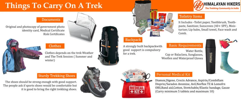
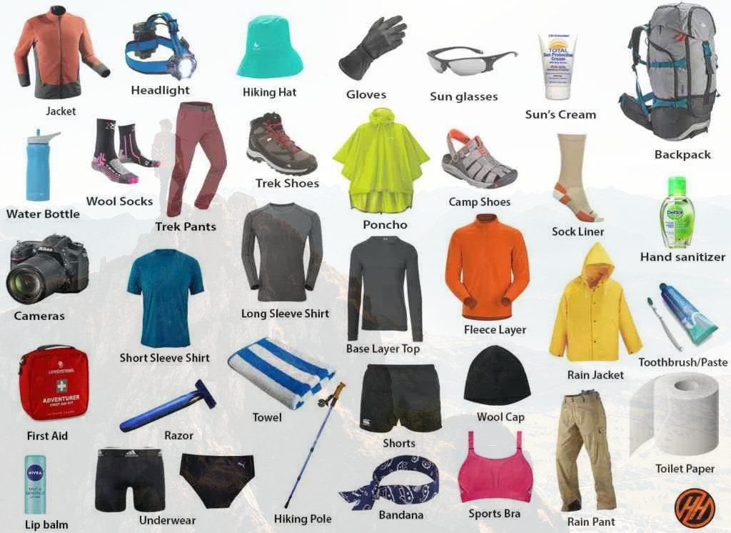
Essential Gear for the Rupin pass Trek Packing List
1. Trekking Gear & Bags
- Main Backpack (50–60 Liters): Must have good hip support and a rain cover.
- Daypack (20 Liters): Essential if you plan to offload your main bag; carries water, snacks, and a jacket.
- Trekking Poles: Highly recommended for stability on snowy slopes.
2. Clothing (The Layering System)
- Base Layer (2-3 Pairs): Quick-dry, moisture-wicking thermals (top and bottom).
- Mid Layer (2): Fleece jackets or sweaters for insulation.
- Outer Layer (2): A high-quality padded down jacket (rated for -10°C).
- Trekking Pants (2): Water-resistant and windproof pants. Avoid jeans at all costs.
- T-shirts (3): Collared, full-sleeve dry-fit tees to prevent sunburst on the neck.
3. Footwear & Socks
- Trekking Boots: High-anchor, waterproof boots with good grip Decathlon Forclaz or similar MH 100) Asain, Jonmart hiking Shoes .
- Woolen Socks (4 Pairs): For sleeping and extra warmth at night.
- Cotton Socks (4 Pairs): For trekking during the day.
4. Headwear & Accessories
- Sun Cap: To protect against UV rays during the day.
- Woolen Cap/Balaclava: Must cover your ears to prevent heat loss.
- Neck Warmer/Buff: Protects your face from cold winds.
- Gloves: One pair of fleece liners and one pair of waterproof outer gloves.
- Sunglasses: Polarized/UV protected to prevent snow blindness.
5. Personal Hygiene & Toiletries
- Sunscreen (SPF 50+) and Lip Balm.
- Moisturizer and Sanitizer.
- Toilet paper and Biodegradable wet wipes.
- Toothbrush, Toothpaste, and a small quick-dry towel.
6. Health & First Aid
- Personal Medikit: Band-aids, crepe bandage, and antiseptic.
- Anti-Altitude Sickness: Diamox (consult your doctor first).
- Pain Relief: Volini spray or Moov.
- Water Purification: Tablets or a LifeStraw.
Quick Tips for a Successful Trek with Himalayan Hikers
- Hydration: Drink at least 3/4 liters of water daily to help with acclimatization.
- Batteries: Cold drains phone and camera batteries fast. Keep them inside your sleeping bag at night to keep them warm.
- Eco-Friendly: "Pack it in, pack it out." Don't leave any plastic on the trail.
Must-Have Medicines for Rupin pass Trek
1. Altitude & Breathing
- Diamox (Acetazolamide): The most common medicine for AMS (Acute Mountain Sickness). It helps your body acclimatize faster.
- Note: Start a preventive dose only after consulting your doctor, as it is a diuretic.
- Camphor (Kapur): Carrying a small pouch of camphor to smell can help some people feel more comfortable while breathing in thin air.
2. Pain & Inflammation
- Combiflam / Ibuprofen: For muscle aches, joint pain, or body fever after a long day of climbing.
- Dolo 650 (Paracetamol): For mild fever or headaches (often a first sign of dehydration or AMS).
- Diclofenac Gel/Spray (Volini/Moov): Essential for calf muscle cramps or knee pain during the descent.
3. Digestive Health (Very Important)
- Digene / Pudin Hara: For acidity or bloating caused by heavy meals at high altitudes.
- Ondem (Ondansetron): For nausea or vomiting (common symptoms of altitude sickness).
- Eldoper / Nor-Metrogyl: For loose motions or stomach infections.
- ORS / Electral: To prevent dehydration. Mix one sachet in your water bottle every day.
4. Respiratory & Cold
- Ascoril/Alex Syrup (or Lozenges): For "Khonchi" (dry mountain cough) caused by cold, dry air.
- Cetirizine / Okacet: For allergic reactions or a runny nose.
- Avomine: If you get motion sickness during the bumpy 8/9-hour drive from Shimla to Jiskun Village
5. First Aid Basics
- Band-aids & Cotton: For small nicks.
- Crepe Bandage: In case of a minor ankle sprain on the snowy trail.
- Betadine/Dettol: Antiseptic for any cuts.
- Anti-fungal Powder: To keep your feet dry and prevent fungal infections from wet socks.
Mandatory Document Checklist for Rupin pass Trek
1. Government Identity Proof (Original + 2 Photocopies)
You must carry a valid, government-issued photo ID. This is required for forest check-posts at and Jiskun village
Accepted: Aadhar Card, Voter ID, Driver's License, or Passport.
Note: Keep two photocopies handy as one will be submitted at the Forest Office for your entry permit.
Trek Insurance mandatory
2. Medical Fitness Certificate
Himalayan Hikers prioritizes safety. You cannot start the trek without a certified medical report.
- Requirement: The certificate must be signed and stamped by a registered medical practitioner (MBBS Doctor).
- Validity: It should usually be issued within 15–30 days of the trek start date.
- Criteria: It should state that your blood pressure, heart rate, and lung health are normal for high-altitude trekking.
3. Disclaimer & Waiver Form
This is a standard indemnity bond provided by Himalayan Hikers.
What it is: A document stating that you understand the risks of high-altitude trekking and are participating voluntarily.
Process: You can usually download this from their website, sign it, and hand it over at the Sankri base camp.
Himalayan Hikers, Training & Safety Plan for Rupin Pass Trek.
6-Week Rupin Pass "Versatility" Training Plan
Weeks 1-2: The Aerobic Base
Running: 3-4 days a week. Focus on distance (5 km). Rupin pass is a long trek 36 km you need "engine" longevity.
Strength:
- Calf Raises: 3 sets of 25. (Crucial for the long meadow walks).
- Lunges: 3 sets of 15 per leg.
Himalayan Hikers Logic: Your lungs need to adapt to the thinning air of the Upper Waterfall camp. Breathe deep and slow.
Weeks 3-4: The "Waterfall" Push (Agility)
Running: 4 days a week. Include stair climbing. Find a flight of stairs and go up/down for 15 minutes.
Weight Factor: Walk 8 km with a 5-7 kg backpack.
Strength:
- Box Jumps or Step-ups: 3 sets of 20. (Simulates the rocky steps leading to the waterfall).
- Plank: 60 seconds x 3.
Weeks 5-6: Peak Endurance (The Gully Phase)
Target: Run 5 km in 32-34 minutes.
The "Final Test": A 12 km walk with an 8 kg backpack.
Technical Prep:
- Burpees: 3 sets of 10. (Builds explosive power for the final steep "Gully" climb).
- Weighted Wall Sits: 90 seconds.
1. Cardiovascular Endurance (Stamina)
You will be trekking for 6–8 hours daily on rocky terrain and snow.
Target: You should be able to run 5 km in 30–45 minutes without stopping.
Alternative: If you prefer cycling, aim to cover 18–20 km in 50 minutes.
Stair Climbing: This is the best prep for the "Waterfall" climb. Try doing 3–4 rounds of 10–15 floors daily.
2. Muscle Strength (Legs & Core)
The ascent to Rupin Pass is very steep, especially through the "Rupin Gully."
- Squats & Lunges: Do 3 sets (15–20 reps) daily to strengthen your knees and thighs.
- Planks: Core strength is vital for balance on narrow ridges. Aim for a 1-minute plank.
- Back Strength: Focus on shoulder and upper back exercises, as you’ll likely be carrying a 7–9 kg backpack.
3. Breathing & Lung Capacity
Oxygen levels drop significantly at high altitudes.
- Pranayama/Deep Breathing: Practice for 10–15 minutes daily to improve lung efficiency.
- Incline Walking: If using a gym, walk on a treadmill set to maximum incline.
Rupin Pass Specific Training Table
| Exercise | Target for Rupin Pass | Why it's different from Bali Pass more treks |
|---|---|---|
| Stair Climbing | 20-30 Floors | Essential for the "Three-Stage Waterfall" which is like a giant natural staircase. |
| Agility Drills | Lateral Shuffles | The trail near Saruwas thatch is rocky and requires quick footwork. |
| Backpack Walk | 8 kg for 10 km | You need to sustain energy over 6-7 days of continuous trekking. |
| Core (Plank) | 90 Seconds | Helps maintain balance when crossing the snow bridges over the Rupin River. |
Why Choose Himalayan Hikers for Rupin Pass Trek ?
- Waterfall Camp Mastery: Most groups struggle with the climb from Lower to Upper Waterfall. Our guides use a "Slow-Step" technique and ensure every trekker is clipped into a safety line if the snow is too slippery.
- The "Sewa" Cultural Experience: We ensure you stay at the ancient Sewa temple village, providing a deep dive into the unique "Kinnauri-Garhwali" fusion culture.
- Gully Safety: The final climb to the pass is a narrow, steep gully. Himalayan Hikers' guides are experts at cutting steps in the snow and managing the "human chain" to ensure no one slips.
- Advanced Weather Monitoring: Rupin Pass is notorious for sudden mist. Our local guides from the Tons valley can navigate the pass even in low visibility using "old-way" landmarks.
What to present at the Dhaula Base Camp:
- The "Stair" Log: Proof that you have practiced vertical climbing (stairs or hills).
- Fitness App Data: Consistent 5km runs to prove cardiovascular recovery.
- Medical Form: Signed by a doctor, specifically noting blood pressure levels.
Essential Rupin Pass Layering
Rupin Pass has a unique micro-climate. It can be hot in the Dhaula meadows and freezing at the Pass.
- The "Waterfall" Shell: A high-quality waterproof jacket is non-negotiable. The spray from the waterfall and the sudden rains at the pass require a 10k-rated waterproof layer.
- Footwear: Mid-to-high ankle boots with aggressive treads for the snow-to-rock transition at the gully.
This is a suggestion that will help you on your trek, but if you are generally fit and healthy, you can prepare according to your own preferences. If you are regular trekker, come and join
Why Himalayan Hikers is the Safest Choice for Rupin Pass Trek
Rupin Pass is not just a hike; it is a legendary "Crossover" trek that connects the Tons Valley in Uttarakhand to the Baspa/Sangla Valley in Himachal Pradesh. It is famous for its changing landscapes—from deep forests to the iconic three-stage waterfall and the final technical "Gully" climb.
1. Technical Safety & Peak Protocol
The Rupin Pass features a dramatic Upper Waterfall climb and a narrow Gully ascent. Safety here requires precision and mountaineering expertise.
NIM & IMF Certified Technical Leads: Our team consists of leaders trained at the Nehru Institute of Mountaineering (NIM). They are experts in "Step Cutting" in frozen snow and anchoring ropes to ensure every trekker crosses the "Gully" safely.
The "Pass-Day" 4:00 AM Strategy: To conquer the 4,650 m summit, we start before dawn. This allows us to cross the frozen snow bridges and the steep Rupin Gully while the snow is still hard, providing maximum grip and safety.
Advanced Medical Support: We carry medical-grade Oxygen cylinders and a comprehensive High-Altitude Medical Kit. We conduct twice-daily Pulse-Oximetry checks at every camp (Lower Waterfall, Upper Waterfall, etc.) to monitor your acclimatization.
Pro-Grade Gear: Himalayan Hikers provides every trekker with specialized Gaiters, Micro-spikes, and Helmets for the final pass day.
2. Expert Logistics: Dhaula to Sangla
Crossing from one state to another requires seamless ground support. We manage the transition from Uttarakhand to Himachal perfectly.
Basecamp Comfort: Your journey begins at our dedicated homestay in Dhaula. You receive a professional technical briefing and a gear check before moving toward Jaka village.
Specialized High-Altitude Shelters: We use 4-season North Face-style Dome Tents. At high camps like Upper Waterfall, where temperatures can hit -10°C, our sub-zero rated sleeping bags keep you warm and recovered.
The Sangla Finish: Unlike others, our service doesn't end at the top. We guide you through the steep descent to Ronti Gad and all the way down to Sangla/Kapa, where transport is waiting to take you forward.
3. Nutrition for the Crossover
At 15,250 feet, your body burns nearly 4,000+ calories on the pass day. We fuel you for the challenge.
Thermogenic Diet: Our menu is designed for cold climates—including ginger-lemon tea, garlic-infused soups (to help natural acclimatization), and high-energy snacks like dates and nuts.
Hydration Command: We strictly enforce the "5L Water Rule." Even at the freezing Upper Waterfall camp, our staff provides warm water to ensure your blood oxygen stays stable.
Rupin Pass Technical Safety Table
| Safety Feature | Benefit to the Trekker | The Himalayan Hikers Edge |
|---|---|---|
| Fixed Ropes & Ice Axes | Safety in the "Rupin Gully" (steept climb). | Our guides fix ropes on the 60-degree incline to ensure no slips. |
| Micro-spikes/Crampons | Solid traction on the Waterfall snow bridges. | Tested, high-traction gear provided to every trekker. |
| Acclimatization Strategy | Reduces the risk of AMS (Altitude Sickness). | We use a gradual ascent via Jaka and Dhanteras to prep your lungs. |
| Radio/Satellite Link | Critical for weather updates. | Constant contact between the Basecamp and the Pass team to monitor wind and snow. |
Why Himalayan Hikers is Different
| Feature | Standard Agencies | Himalayan Hikers |
|---|---|---|
| Route Knowledge | Follow general trails. | Local Legends: Our guides are from these valleys; they know every rock and shortcut. |
| Campsite Selection | Standard, often crowded spots. | Strategic Camps: We choose wind-shielded spots at Upper Waterfall for better sleep. |
| Technical Gear | Basic or rented. | Pro-Grade: We own and maintain our equipment to global safety standards. |
| The Transition | Trek ends at the pass. | Full Cycle: We manage your descent into Himachal and coordinate your exit from Sangla. |
| Category | Details |
|---|---|
| Transport | Shimla to Shimla round-trip via Tempo Traveller (Pickup & Drop) |
| Permits & Entry | Forest Permit and Entrance Fees |
| Accommodation | Hotel Homestay, Tented Accommodation on Twin Sharing |
| Meals | Breakfast, Lunch, Tea, Coffee, Snacks, Soup, Dinner (All meals included) |
| Camping Gear | High-Quality Dome Tents, Sleeping Bags, Mattress, Liner |
| Sanitation Setup | Separate Toilet Tents (Ladies & Gents), Dining Tent, Dining Table, Camping Chair |
| Support Staff | Kitchen Team, Trek Helpers |
| Communication Tools | Radio Walkie-Talkie |
| Trek Guides | Experienced Trek Leader & Technical Guide |
| Safety Equipment | Medical Kit, Oxygen Cylinders, Pulse Oximeter |
| Trekking Equipment | Crampons, Gaiters, Helmate , Ice ax |
| Category | Details |
|---|---|
| Meals (Not Included) | – Day 1: En route Breakfast & Lunch to base camp– Day 7: En route Dinner (not included) |
| Insurance & Documents | – Personal Insurance– Medical Certificate (Mandatory) |
| Personal Essentials | – Personal Toiletry Items– Personal Medical Kit |
| Porter Service | – Porter fee: ₹500 per day (to be paid directly at Jiskun base camp)– Minimum bag weight for porter: 8 kg |
| Foreign Nationals | – ₹2400 extra for trekking permit– Passport and valid Visa required |
Important Note
Himalayan Hikers offers both online and offline booking options for their treks. Here’s a breakdown of both options:
1. Online Booking:
- Website: Himalayan Hikers has an official website where trekkers can browse through different treks, check details (itineraries, costs, difficulty level, etc.), and make bookings. Payment gateways are integrated for secure online transactions.
- Third-Party Platforms: They might also be listed on various trekking or adventure booking platforms, where you can compare prices, read reviews, and make bookings.
- Email Communication: Trekkers can inquire about treks via email and complete the booking process online, following email communication and payment.
2. Offline Booking:
- Direct Office Visit: Himalayan Hikers has physical offices (especially in Uttarakhand), where trekkers can visit in person, discuss treks, and complete bookings directly.
- Phone Booking: You can also call their office to make a booking. Details about payment methods, trek dates, and other logistics can be confirmed over the phone.
Yes, Himalayan Hikers requires a 25% advance payment for booking treks, Via- Google pay or UPI, Directly Himalayan Hikers Account with the remaining amount to be paid in cash at their branch office in Sankri before the trek starts. This payment structure is typical for ensuring that bookings are confirmed while allowing trekkers flexibility in completing the payment when they arrive.

The best time for the Rupin Pass Trek is in two seasons:
- Pre-Monsoon (May to June): Expect snowy landscapes, thrilling snow crossings, and cold weather.
- Post-Monsoon (September to October): Enjoy clear skies, lush meadows, and the vibrant colors of autumn.
The highest point on the trek is the Rupin Pass, which is situated at 15,250 feet (4,650 meters)
The trek is moderate to challenging. It involves long trekking days, steep ascents, and some tricky sections, particularly near the pass. Prior trekking experience and good physical fitness are recommended.
The trek typically lasts 7-8 days, covering a distance of approximately 52 km from Dhaula in Uttarakhand to Sangla in Himachal Pradesh.
While it’s not mandatory, having some prior trekking experience at moderate altitudes is beneficial. Trekkers should be prepared for high-altitude conditions and be in good physical shape.
Pre-Monsoon (May-June): Day temperatures range from 10°C to 15°C at lower altitudes, while nights can drop to -5°C to 5°C at higher camps.
Post-Monsoon (September-October): Day temperatures range from 10°C to 18°C, with night temperatures around 0°C to 7°C at higher camps.
Trekking shoes with good grip and ankle support.
- Warm clothing, including layers, a down jacket, and thermals for cold nights.
- Trekking poles for stability on steep and snowy sections.
- Rain gear (jacket and pants) to prepare for unexpected weather changes.
- Sleeping bag, if not provided by the trekking operator.
- First aid kit, including medicines for altitude sickness, pain relief, and any personal medications.
You’ll need permits as the trek passes through government-protected areas. These permits are usually arranged by the trekking company you book with. Carry a valid ID for the registration process.
Accommodation is typically in tents on a twin or triple-sharing basis. In some villages like Jhaka, you may stay in homestays or guesthouses. The quality is basic, but adequate for trekkers.
Most trekking companies provide nutritious vegetarian meals during the trek. Meals typically include dal, rice, chapati, vegetables, soup, and snacks like tea, biscuits, and energy bars. If you have specific dietary needs, inform the operator in advance.
Mobile network coverage is very limited. You may find some network in lower villages like Sewa, but as you ascend, expect no network for the majority of the trek.
It’s possible, but not recommended due to the remote nature of the trek and the need for navigation through snow and tricky sections. Joining a group trek or hiring a guide is safer.


