


Goecha La Trek – A Journey into Himalayan Grandeur
The journey of the Goecha La Trek begins in the historic village of Yuksom, a peaceful settlement surrounded by the lush beauty of Sikkim. This scenic village serves as the perfect starting point for an unforgettable Himalayan adventure. From here, the trail gradually ascends through dense forests filled with towering trees, chirping birds, and the soothing sounds of nature.
As trekkers move forward, they pass through the charming hamlet of Tshoka, known for its traditional wooden huts and warm local hospitality. The trail then leads into vibrant rhododendron forests, which are especially stunning during spring when the entire landscape bursts into bright colors. Further ahead, trekkers reach the vast alpine meadows of Dzongri, offering breathtaking views of snow-covered peaks and a true sense of Himalayan wilderness.
Why Choose the Goecha La Trek?
- Closest and most stunning sunrise view of Mount Kanchenjunga from India
- UNESCO World Heritage trail inside Khangchendzonga National Park
- Dense and colorful rhododendron forests, especially in spring
- Beautiful meadows of Dzongri and Thansing
- Iconic Samiti Lake, a pristine glacial lake
- Long and satisfying Himalayan trekking days
- Scenic wooden bridges, forest streams, and moss-covered trails
- High-altitude challenge with rewarding landscapes
- Perfect for trekkers seeking a true Himalayan expedition
One of the most serene highlights of the trek is Samiti Lake, a sacred and crystal-clear glacial lake surrounded by towering mountains. The calm waters reflect the surrounding peaks like a mirror, creating a magical and peaceful atmosphere that leaves trekkers amazed.
The most awaited moment of the trek is the early morning climb to Goecha La View Point 1. Trekkers begin their ascent before sunrise, walking under a sky full of stars. As the sun rises behind Mount Kanchenjunga, the sky turns shades of orange and gold, and the entire mountain range lights up beautifully. This breathtaking view is unforgettable and remains in memory for a lifetime.
The Goecha La Trek is not just a route but a complete experience. It is a journey that teaches patience, builds strength, and creates a deep connection with nature. It offers not only adventure but also a sense of peace and spiritual awakening in the heart of the Himalayas.
Goechala Trek Complete Guide
Our mission has always been to ensure that no trekker steps into the Himalayas without the right perspective. A trek is not just a checklist of summits; it is a serious commitment to the outdoors. Having the right information is what separates a reckless climb from a soulful journey.
This section serves as your definitive manual for the Goechala Trek. We have distilled years of mountain experience and real-time feedback into this guide to give you a clear, honest picture of the trail.
We provide this depth of information because we want you to be more than just a visitor—we want you to be a prepared, responsible trekker who respects the mountains as much as we do.
Day 1: Arrival at Yuksom (5,670 ft)
Explore Dubdi Monastery, Coronation Throne of Norbugang, and village life.
Day 2: Yuksom → Sachen (5,670 ft → 7,200 ft, 8 km, 4–5 hrs)
Trek through dense forests with scenic suspension bridges.
Day 3: Sachen → Tshoka (7,200 ft → 9,700 ft, 7 km, 5–6 hrs)
Climb to Bakhim and reach the Tibetan settlement of Tshoka.
Day 4: Tshoka → Dzongri (9,700 ft → 13,100 ft, 10 km, 6–7 hrs)
Steep ascent through rhododendron valleys to high-altitude meadows.
Day 5: Acclimatization at Dzongri
Explore Dzongri Top for sunrise and panoramic Himalayan views.
Day 6: Dzongri → Thansing (13,100 ft → 12,900 ft, 10 km, 6–7 hrs)
Descent to Thansing meadow surrounded by peaks.
Day 7: Thansing → Lamuney (12,900 ft → 13,600 ft, 4 km, 2–3 hrs)
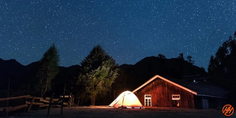
Short walk to the final camp; enjoy Samiti Lake and clear night skies.
Day 8: Lamuney → Goecha La Viewpoint → Thansing (13,600 ft → 16,200 ft, 12–14 km, 8–9 hrs)
Early start to witness the sunrise at Goecha La Viewpoint 1. Return to Thansing.
Day 9: Thansing → Tshoka
Descend through forests and bridges.
Day 10: Tshoka → Yuksom
Final descent; overnight stay.
Day 11: Yuksom → NJP/Bagdogra
Departure with unforgettable Himalayan memories.
Day 1
Day 2
Day 3
Day 4
Day 5
Day 6
Day 7
Day 8
Day 9
Day 10
Day 11
Day 1: Pickup from New Jalpaiguri railway station (NJP) and Drive to Yuksom base camp
Total distance: 210 km – 150 km – 6/7 Hours journey
Mode of journey: By taxi
Altitude: Yuksom base – 5,700 feet
Night stay: Our Hotel – on twin share basis
Reach NJP railway station at 6:00 am. The vehicle will be arranged from there and the drive is towards Yuksom base camp. For entry, carry passport size photographs and original ID proof. The rules are different for foreigners.
Trekkers should carry Photo ID, Aadhaar card, Passport, Visa for entry at Police check posts on the trek. It is very important. Foreigners need an Inner Line Permit.
Reach Yuksom base camp by 6 pm; a beautiful town of Sikkim, it was once the capital and has several interesting sites. There is a glimpse of their rich heritage and culture. Explore this historic town in the evening; arrangements will be made in a hotel.
Day 2: Trek from Yuksom base camp to Sachen camp
Trek Distance: 08 km – 5/6 Hours journey
Mode of journey: On foot
Altitude: Sachen – 7,200 feet
Night Stay: Camp – on twin share basis
After breakfast, trek from Yuksom, the starting point of the Goecha La trek. The trail passes along the beautiful fields of Yuksom and then goes through Rathong river valley. Trek through dense forests where sunlight enters irregularly.
There are some slippery sections ahead. The attraction of this trail is the “Tshushay Khola falls” – many small waterfalls joining the Prek River. Some log huts will be visible along the way.
Reach your campsite Sachen lying at an altitude of 7,200 feet. Below it flows the River Prek, and the sounds of this gushing river can be heard. Set up your camps and retire for the night.
Day 3: Trek from Sachen to Tsokha camp (9,700 feet) via Bakhim
Trek Distance: 07 km – 4/5 Hours journey
Mode of journey: On foot
Altitude: Tsokha camp – 9,700 feet
Night Stay: Camp – on twin share basis
Trek from Sachen to Tsokha is a steep ascent. Cross the Prek River over a bridge; see the Buddhist prayer flags on the bridge, which look beautiful while they sway in the air.
After crossing the bridge, ascend through forests of Rhododendrons and Oaks. Trek through Bakhim and reach Tshoka. The malt “Tumba” is very famous there; find it in the local cafes. At the monastery of Tshoka, get amazing views of the whole Kangchenjunga range and Pandim.
After setting up the camps, have a sumptuous meal and retire for the night.
Day 4: Trek from Tsokha camp to Dzongari camp (12,980 feet) via Phedang
Trek Distance: 09 km – 8/9 Hours journey
Mode of journey: On foot
Altitude: Dzongari – 12,980 feet
Night Stay: Camp – on twin share basis
Wake up early, have some breakfast, and start the trek with a packed lunch. The trail from Tsokha to Dzongari is picturesque; the climb is steep, but if you trek in spring, the blooming Rhododendrons amid the forest will amaze you.
After crossing this section, you reach Phedang, a wide forest clearing which offers excellent views of high mountains. Follow the trail to reach the spectacular meadow of Dzongari, which lies amid the Kangchenjunga range.
Standing here and watching the rising peaks of the Himalayas in every direction will fulfill your desire for unmatched views. Set up your camp and settle for the day.
Day 5: Rest Day + Acclimatization Day
Wake up late morning around 8 am, have a good breakfast around 10 am, and enjoy the camp. Today is the acclimatization day at Dzongari; go for a short hike.
Trek to Dzongari Top and spot these peaks:
Kabru South & Kabru North
The Kabru Dome & Freky Peak
Kumbakarana
Kangchenjunga
Simro
Pandim
Jupono
Rathong
Return to your camps and explore the nearby areas.
Day 6: Trek from Dzongari to Thansing camp (12,900 feet) via Kokcharang
Trek Distance – 10 km – 6/7 Hours journey
Mode of journey – On Foot
Altitude – Thansing – 12,900 feet
Night Stay – Our camp – on twin share basis
Do not miss witnessing the sunrise from Dzongari Top because the changing color of peaks will make you stare at them. It is a 1 km trek. The top offers 180-degree views of Kangchenjunga peaks and Singalila ranges.
Thansing is visible from Dzongari Top. Descend to reach Kokcharang and from there start the ascent to Thansing. Cross Prekchu River over a bridge, and after a 2 km trek through a boulder zone, reach Thansing which lies at an altitude of 12,900 feet.
Set up your camps, wear enough to protect yourself against cold, and retire for the night.
Day 7: Trek from Thansing to Lamuney camp
Trek Distance – 04 km – 3/4 Hours journey
Mode of journey – On Foot
Altitude – Lamuney – 13,650 feet
Night Stay – Our camp – on twin share basis
The trek from Thansing to Lamuney is an easy one on the levelled trail and it is the easiest day of Goechala trek. Go through the undulating meadows and reach the campsite in 3 hours.
Move towards Samiti Lake which lies ahead of your campsite. The trail is rocky and steep. There you can spot colorful birds and mountain goats around this lake. Camping is restricted here, so after spending good time there, get back to Lamuney. At Lamuney, retire for the night.
Day 8: Trek from Lamuney to Goechala summit (15,100 feet) via Samiti Lake and descent to Thansing
Distance – 17 km – 11/12 Hours journey
Mode of journey – On foot
Altitude – Goechala summit – 15,100 feet
Night Stay – Camp site – on twin share basis
Today is the toughest and longest day of this trek. So start early to have enough time for ascending and descending. Head towards Samiti Lake, now the steep ascent starts towards Goechala which lies at an elevation of 15,100 feet. Cross the steep climb and reach a narrow ridge, pass through it carefully because it moves through mountain sides. Witness the sunrise changing the color of snow covered peaks, it looks bewitching.
Spot these peaks from here –
Kabru South & Kabru North
The Kabru Dome & Kangchenjunga
Gocha Jupono
Sinvo
Tenzingkhang
After good time at the Goechala viewpoint, start the descent to Lamuney. Have lunch there and get down to Thansing. Settle for the day in your camps.
Day 9: Trek from Thansing to Tsokha (9,700 feet) via Phedang
Distance – 16 km – 7/8 Hours journey
Mode of journey – On foot
Altitude – Tsokha – 9,700 feet
Night Stay – Camp site – on twin share basis
Go through the forests section and the trek is mostly on flat land with some ascents and descents. The beautiful Rhododendrons on the way and sight of Mt. Pandim makes the hike pleasant.
Reach Phedang, rest here in the rich ambience for some time. Now, descent towards Tsokha; it is 5 km way from this point. Pass through the rich areas of Flora and Fauna. Do not take many breaks on the way to reach Tsokha on time.
Setup your camps there and retire for the night.
Day 10: Trek from Tsokha to Yuksom (5,700 feet) via Bakhim and Sachen
Distance – 15 km – 6/7 Hours journey
Mode of journey – On foot
Altitude – Yuksom – 5,700 feet
Night Stay – Camp site – on twin share basis
Follow the same path from Tshoka to Yuksom, the trek is an easy one. Pass through Bakhim and Sachen. Take a short break there and continue the descent.
Now, cross some ascents and reach Yuksom. Arrangements will be made in a hotel, have delicious food and sleep comfortably.
Day 11: After breakfast Drive from Yuksom to New Jalpaiguri (NJP) (150 km) (7/8 hours) reach evening 5 to 6 pm
Distance – 150 km – 7/8 Hours journey
Mode of journey – By taxi
Today is last breakfast with team Himalayan hikers, the trekkers’ departures day from Yuksom to NJP Railway station.
Reached Jalpaiguri (NJP) evening 4 to 6 pm. You can book your train any time after 7:00 pm.
Difficulty Level – Goecha La Trek
The Goecha La Trek is considered a moderate to challenging trek, making it suitable for trekkers who have a good level of physical fitness and some prior trekking experience. This trek takes you to high altitudes, reaching approximately 4,600 meters at Goecha La View Point 1, which makes acclimatization an important part of the journey.
One of the main challenges of this trek is the long trekking days. Trekkers are required to walk for 6 to 8 hours daily, covering steep ascents, descents, and uneven terrain. The trail includes forest paths, rocky sections, and high-altitude landscapes, all of which require stamina and endurance.
The altitude gain is another important factor that adds to the difficulty level. As trekkers move higher, oxygen levels decrease, which can lead to altitude sickness if proper acclimatization is not followed. Rest days at places like Dzongri are essential to help the body adjust to the changing altitude.
Weather conditions in the region can also be unpredictable. Trekkers may experience cold temperatures, strong winds, and sudden weather changes, especially during early morning summit climbs. Proper clothing and preparation are necessary to handle these conditions comfortably.
Despite the challenges, the Goecha La Trek offers an extremely rewarding experience. The journey through dense forests, vibrant rhododendron valleys, vast meadows, and glacial landscapes provides a perfect blend of adventure and natural beauty. The highlight of the trek, the sunrise view of Mount Kanchenjunga, makes all the effort worthwhile.
Overall, the Goecha La Trek is ideal for those looking for a true Himalayan adventure. With the right preparation, fitness, and mindset, trekkers can successfully complete this trek and enjoy one of the most breathtaking experiences in the Indian Himalayas.
Best Time to do Goecha La
Spring (April – June)
Spring season me Goecha La trek sabse zyada colorful aur lively lagta hai. Is time par rhododendron flowers full bloom me hote hain, jisse poora trail bright aur scenic ban jata hai. Weather bhi kaafi pleasant hota hai, na zyada thand na zyada garmi, jo trekking ke liye perfect conditions deta hai. Is dauran Samiti Lake ka turquoise color bhi bahut stunning dikhta hai, jo trek ka ek major highlight hota hai. Nature lovers aur peaceful experience chahne walon ke liye yeh best time hai.
Autumn (September – November)
Autumn season ko Goecha La trek ke liye overall best mana jata hai, kyunki is time sky bilkul clear hota hai aur Kanchenjunga ke breathtaking views milte hain. Viewpoint 1 se sunrise ka scene especially bahut dramatic aur memorable hota hai. Weather iss period me sabse stable rehta hai, rain ya snowfall ka risk kam hota hai, isliye trekking conditions safe aur predictable hoti hain. Photography aur mountain views ke liye yeh perfect season hai.
Avoid (July – August & December – February)
Monsoon months me heavy rainfall, leeches aur landslides ka risk hota hai, jo trek ko unsafe bana deta hai. Wahi winter me extreme cold aur deep snow ki wajah se routes block ho sakte hain aur trekking dangerous ho jati hai. Isliye in dono periods me Goecha La trek avoid karna hi better hota hai.
By Train
- Nearest Railway Station: New Jalpaiguri Junction (NJP)
- Distance: Approximately 150 km from Yuksom
By Flight
- Nearest Airport: Bagdogra Airport (IXB)
- Distance: Approximately 155 km from Yuksom
Common Routes
- NJP → Jorethang → Yuksom
- Bagdogra → Jorethang → Yuksom
- Gangtok → Yuksom (commonly used by foreign travelers)
Yuksom serves as the starting point of the Goecha La Trek. From NJP or Bagdogra, travelers can hire a taxi or take shared transport to reach Yuksom via Jorethang. The journey offers scenic views of mountains, rivers, and traditional Sikkimese villages, making it an enjoyable start to the trek.
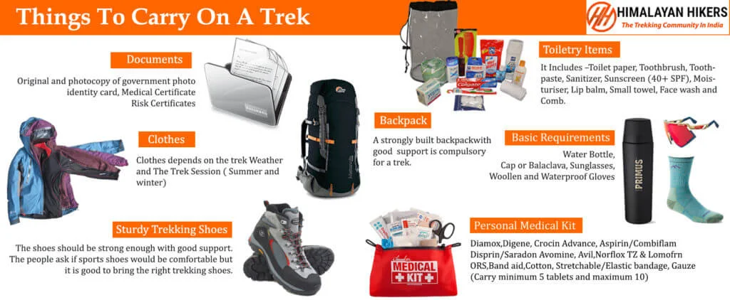
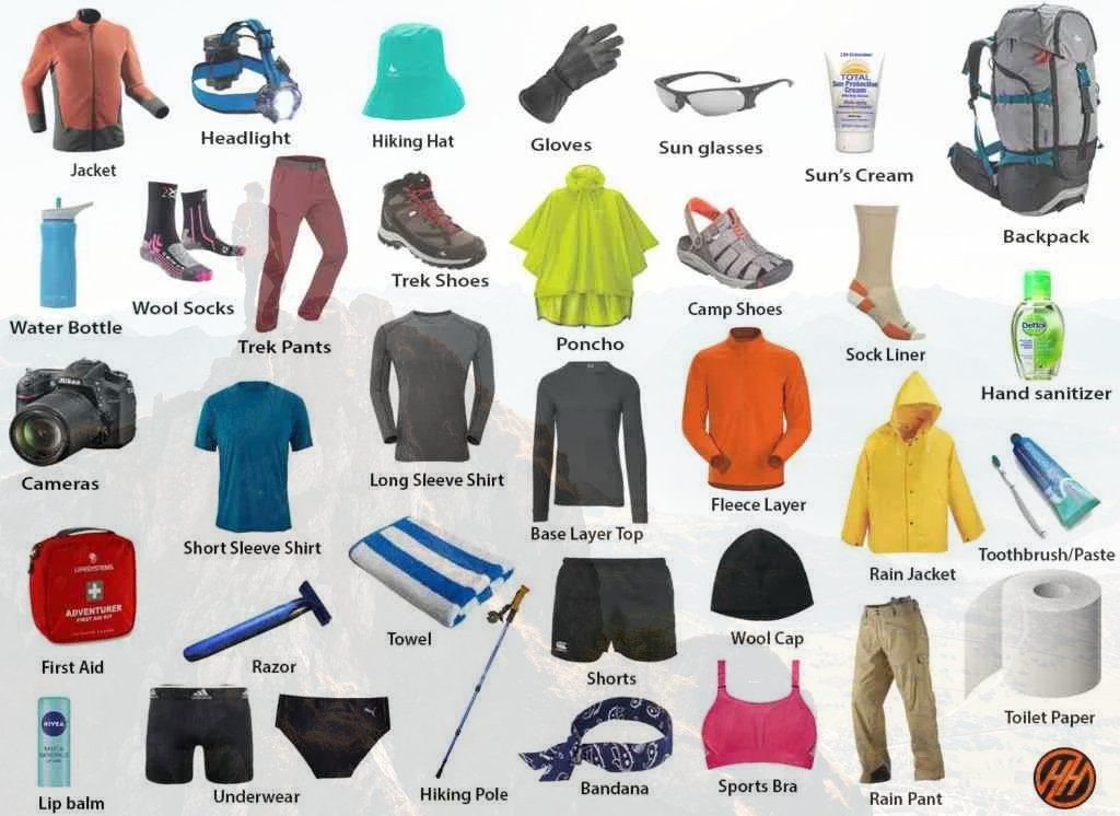
What to Pack for Goecha La Trek
Clothing
- Thermal wear (top & bottom) – 2 pairs
- Fleece jacket – 2
- Insulated jacket (down jacket) – 1
- Waterproof jacket or poncho – 1
- Quick-dry t-shirts – 2–3
- Trekking pants – 2 pairs
- Woolen socks – 2 pairs
- Gloves, woolen cap, and scarf – 1 set
Footwear
- Sturdy trekking shoes with good grip – 1 pair
- Lightweight slippers or sandals (for camps) – 1 pair
- Extra socks – 2 pairs
Essentials
- Backpack (50–60L) with rain cover – 1
- Water bottles or hydration pack – 2
- Sunscreen (SPF 50+) – 1
- Sunglasses and cap – 1 each
- Personal toiletries – as needed
- Quick-dry towel – 1
Trekking Gear
- Trekking pole – 1 pair
- Headlamp or torch with extra batteries – 1
- Power bank – 1–2
- Small daypack – 1
Health & Safety
- Basic first-aid kit – 1
- Personal medicines – as required
- Altitude sickness medication – as required
- Hand sanitizer and wet wipes – 1 each
- ORS (hydration salts) – 2–3 sachets
How to Prepare for the Trek
Physical Preparation
- Start training at least 6–8 weeks before the trek.
- Focus on cardio exercises like running, cycling, or brisk walking to improve stamina.
- Include strength training such as squats, lunges, and core workouts.
- Practice hiking with a backpack on uneven terrain.
Acclimatization
- Allow your body time to adjust to high altitude during the trek.
- Follow a gradual ascent and include rest days, especially at Dzongri.
- Stay hydrated and avoid overexertion to reduce the risk of altitude sickness.
Essential Gear
- Carry proper trekking shoes with good grip and ankle support.
- Wear layered clothing suitable for cold and changing weather.
- Bring a good-quality backpack, sleeping bag, and trekking poles.
- Pack essentials like a headlamp, water bottle, sunscreen, and first aid kit.
Permits and Documentation
- Obtain permits for Khangchendzonga National Park.
- Carry valid ID proof and required documents.
- Foreign nationals may need additional permits and must follow specific entry rules.
Nutrition and Hydration
- Maintain a balanced diet before and during the trek.
- Drink enough water throughout the day.
- Carry energy snacks like dry fruits, chocolate, or energy bars.
Mental Preparation
- Be ready for long trekking hours and physical challenges.
- Stay patient and maintain a positive mindset.
- Adapt to basic living conditions during the trek.
Final Tips
- Pack light but carry all essential items.
- Follow your guide’s instructions at all times.
- Respect nature and local culture.
- Travel insurance is highly recommended.
Safety with Himalayan Hikers
Safety is a top priority while trekking in high-altitude regions like the Himalayas. Trekking with experienced Himalayan hikers or professional guides ensures a secure, well-managed, and enjoyable journey on the Goecha La Trek.
Experienced Guides
- Trained and certified guides with strong knowledge of the trekking route.
- Familiar with weather conditions, terrain, and local environment.
- Provide guidance and support throughout the trek.
Health and Altitude Safety
- Guides monitor trekkers for signs of altitude sickness.
- Proper acclimatization schedules are followed during the trek.
- Immediate action is taken in case of any health issues.
Emergency Support
- First aid kits are carried at all times.
- Guides are trained to handle emergencies and basic medical situations.
- Quick coordination for evacuation if required.
Safe Trekking Practices
- Well-planned itineraries to avoid overexertion.
- Use of safe and established trekking routes.
- Regular breaks and proper pacing during the trek.
Group Safety
- Trekking in groups ensures better coordination and support.
- Reduces the risk of getting lost in remote areas.
- Encourages teamwork and a safer trekking experience.
Conclusion
- Trekking with Himalayan hikers ensures safety, comfort, and guidance.
- Professional support helps in managing risks and challenges effectively.
- It allows trekkers to focus on enjoying the journey with peace of mind.
Accommodation: Day 1st accommodation in hotel. Day 2nd to Day 14th accommodation in Tea House.
Permit: All Necessary Trek permit. Transportation: Jalpaiguri to Jalpaiguri, Both Way by Flight.
Offloading: 10 kg Offloading facilities for every trekker (we provide duffle bag individually).
Medical Support: Strong Medical kit, Oxygen can, Oximeter.
Safety Equipment: Micro Spike and Gaiter (as per snow condition)
Group Leader: Experienced Trek leader.
Additional Service: Cloakroom room facility available at Lukla.
Food Service: Three time meal include (Breakfast, Lunch and Dinner)
Trek Completion Certificate.
Transport - 4,000 /- INR. Jalpaiguri to Jalpaiguri and return by car.
Emergency evacuation and hospitalization charges.
Insurance cost not included. For trekkers aged 50 and above, personal insurance is mandatory (no trek permit will be issued without insurance).
Important Note
Note: You must carry your original Voter and Aadhaar cards with you when traveling Goechala Trek.
Note 1: In the event that an extra day is required for the trekking itinerary due to unforeseen weather conditions, government orders, socio political unrest, self-injury or any others illness during trek. Additional cost of ₹3,500/- (Three Thousand Five Hundred Indian Rupees) per day will be incurred. This cost must be paid by the trekkers.
Note 2: In case any trekker is injured or medically not fit to carry out the trek, He or She has to descend, we could be arranged for the same however the trekkers have to bear the expenses for the descend. The same is applicable for someone wiling not to continue the trek.
Map not available for this trek.
BSNL works in Yuksom.
Beyond that, trekkers rely on guides or satellite communication.
certified guide or registered trekking group,
solo female trekkers can safely complete the journey.
post-monsoon months (October–November) provide the
clearest skies, perfect lighting, and striking landscapes for capturing
memorable photographs.


